Introduction
Earthquakes, one of nature’s most destructive phenomena, are sudden and violent shakes of the Earth’s surface caused by the release of energy from within the Earth’s crust. These seismic events can lead to widespread destruction, loss of life, and displacement of communities within seconds. The recent earthquake in Tibet on January 7, 2025, measuring approximately 7 on the Richter scale, is a stark reminder of the devastating effects of seismic activity. This blog examines the underlying science of earthquakes, particularly in the Himalayan region, their impacts, and strategies for preparedness and mitigation.
The Himalayan Region: A Seismically Active Zone
Causes of Earthquakes in the Himalayas
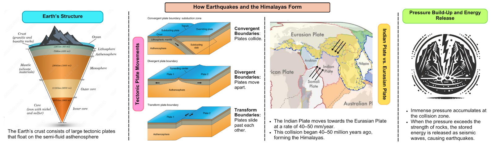
Earthquakes in the Himalayan region are largely driven by the ongoing collision between the Indian and Eurasian tectonic plates. This tectonic interaction began around 40-50 million years ago, resulting in the formation of the Himalayan mountain range. The two plates continue to converge at a rate of 40-50 mm per year, creating immense pressure along fault lines. This pressure stores elastic energy, which is released periodically in the form of earthquakes.
Geological Evolution of the Himalayas
The Himalayan mountain range began forming as the dense Indian Plate collided with the relatively less dense Eurasian Plate. Both plates, having similar densities, resisted subduction, leading to the uplifting and folding of the landmass. This continuous tectonic movement has made the region one of the most seismically active zones in the world.
High-Risk Zones in the Himalayas
The western Himalayas, spanning the Hindu Kush to Arunachal Pradesh, constitute one of the world’s most dangerous seismic zones. The Hindu Kush region alone has experienced at least five earthquakes exceeding a magnitude of 7 since 1950. These areas remain vulnerable due to the accumulation of elastic energy along fault lines.
The 2025 Tibet Earthquake: A Recent Case Study
On January 7, 2025, an earthquake measuring around 7.0 on the Richter scale struck Tibet, with its epicenter located approximately 75 kilometers northeast of Mount Everest. This event left around 100 people dead, caused significant structural damage to approximately 1,000 houses, and underscored the persistent seismic threat in the region.
Future Threats in the Himalayan Region
Geological studies reveal that the Himalayas are “due” for a major earthquake, possibly exceeding a magnitude of 8. A 2017 study reported that only two Himalayan earthquakes in the past 500 years have ruptured to the surface, suggesting a significant buildup of elastic energy in the fault lines. Scientists warn that the consequences of such an event could be catastrophic for densely populated areas.
The Science of Earthquakes
Mechanism of Earthquake Occurrence
Earthquakes occur due to a sudden release of energy in the Earth’s crust, which generates seismic waves. The process involves:
- Stress Accumulation: Tectonic plates lock at their edges due to friction, building stress along fault lines.
- Elastic Strain: Rocks near the fault lines deform elastically, storing potential energy.
- Rupture: When stress surpasses rock strength, the fault plane ruptures.
- Energy Release: Stored elastic energy is released as seismic waves.
- Wave Propagation: These waves spread from the earthquake’s focus in all directions.
- Ground Shaking: The seismic waves reaching the surface cause the ground to shake, leading to visible effects of earthquakes.
Types of Seismic Waves
During an earthquake, three major types of seismic waves are produced:
- P-waves (Primary waves): Compressional waves that move particles parallel to wave direction.
- S-waves (Secondary waves): Shear waves causing particles to oscillate perpendicular to the wave direction.
- Surface waves: Result from P and S waves at the surface, causing significant damage (e.g., Love and Rayleigh waves).
Plate Tectonic Interactions
Tectonic plate movements are central to earthquake activity, occurring at three types of boundaries:
- Convergent Boundaries:
- Plates move toward each other.
- Examples: Andes Mountains (oceanic-continental), Himalayan orogeny (continental-continental).
- Features: Subduction zones, trenches, and volcanic arcs.
- Divergent Boundaries:
- Plates move apart, creating new crust.
- Examples: Mid-Atlantic Ridge, East African Rift.
- Features: Rift valleys, mid-ocean ridges.
- Transform Boundaries:
- Plates slide past each other horizontally.
- Example: San Andreas Fault.
- Features: Transform faults, shallow earthquakes, no volcanic activity.
Understanding these mechanisms and boundaries aids in predicting earthquakes and mitigating their risks effectively.
Types of Earthquakes
- Tectonic Earthquakes: Caused by the movement of tectonic plates.
- Volcanic Earthquakes: Resulting from volcanic activity, where magma movement fractures rocks.
- Collapse Earthquakes: Occurring in regions with collapsing underground caverns or mines.
- Explosion Earthquakes: Induced by human activities such as underground nuclear tests or large explosions.
Measuring Earthquakes
Earthquakes are measured using specialized tools and scales:
- Seismographs: Instruments that detect and record seismic waves.
- Richter Scale: Measures the magnitude of an earthquake on a scale of 0 to 10, with each unit representing a 32-fold increase in energy release.
- Moment Magnitude Scale: A more precise tool for measuring large earthquakes, now widely used by scientists.
Impacts of Earthquakes
Primary Effects
- Ground Shaking: The immediate shaking causes buildings to sway or collapse.
- Surface Rupture: Fault lines may produce visible ruptures on the Earth’s surface.
- Landslides: Common in mountainous areas, triggered by ground shaking.
Secondary Effects
- Tsunamis: Large underwater earthquakes can displace water, generating massive waves that impact coastal regions.
- Liquefaction: Saturated soils lose their stability, causing buildings to sink or tilt.
- Fires: Damaged gas pipelines and infrastructure can lead to widespread fires.
- Economic Loss: Destruction of infrastructure and businesses results in significant economic disruptions.
- Environmental Changes: Earthquakes can alter landscapes, drain lakes, or create new landforms.
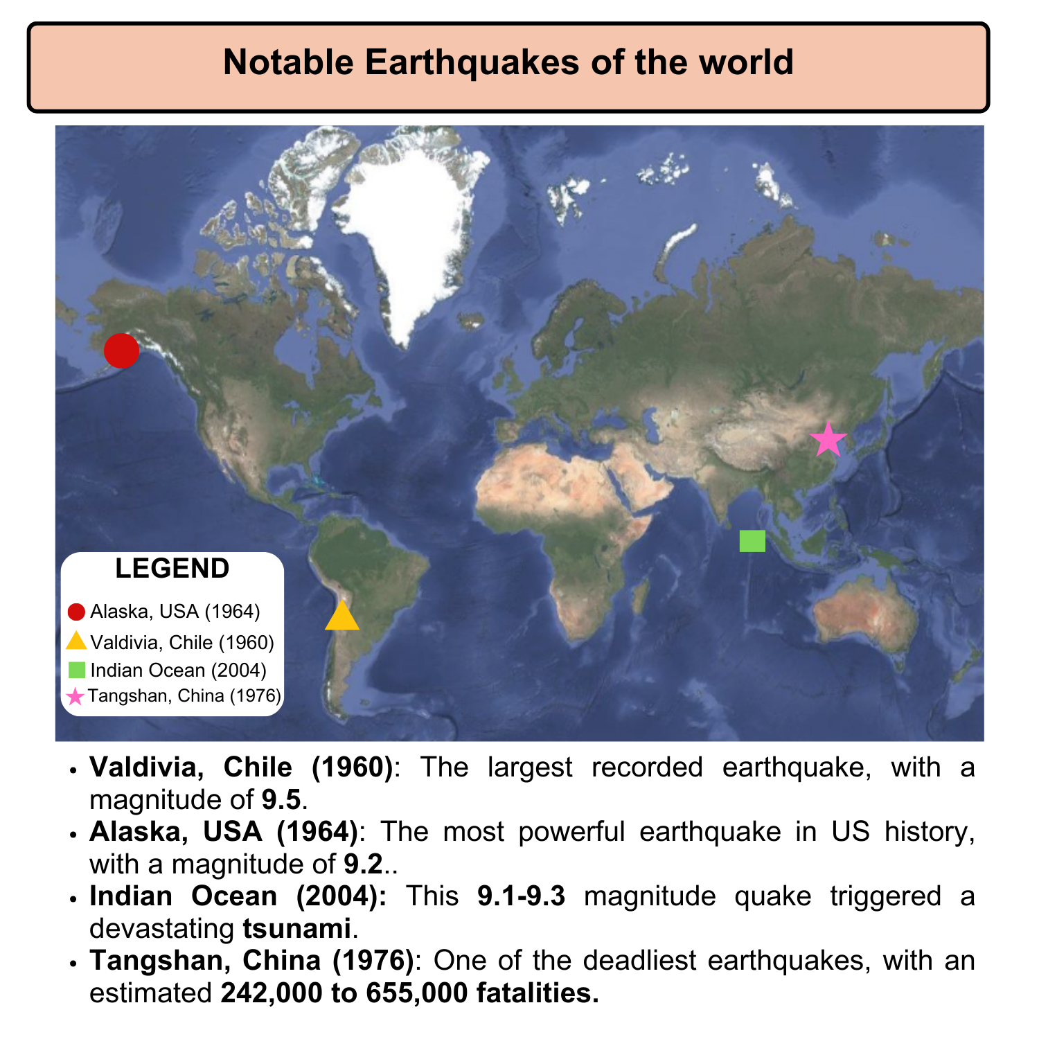
Notable Earthquakes in History
- Valdivia, Chile (1960): The most powerful earthquake on record, with a magnitude of 9.5.
- Alaska, USA (1964): The largest earthquake in U.S. history, with a magnitude of 9.2.
- Indian Ocean (2004): Triggered a devastating tsunami, killing over 230,000 people across multiple countries.
- Tangshan, China (1976): One of history’s deadliest earthquakes, claiming an estimated 242,000-655,000 lives.
Earthquake Research, Preparedness, and Global Best Practices
- Earthquake Forecasting: Although precise prediction remains elusive, scientists can identify regions with high seismic risk based on historical data.
- Early Warning Systems: Countries like Japan have implemented warning systems that provide seconds to minutes of notice before shaking starts, enabling emergency protocols.
- Resilient Infrastructure: Engineers design buildings with earthquake-resistant features, including seismic base isolators and energy dissipation systems.
A key example of earthquake readiness is Chile, which has successfully minimized quake impacts through stringent building codes, regular structural testing, advanced construction techniques, and public education.
Assam and its Seismic Vulnerability
Assam, located in northeastern India, lies in a high seismic risk zone. The region has experienced several major earthquakes, including:
- Great Assam Earthquake of 1897: Magnitude 8.2-8.3; caused widespread destruction and claimed 1,542 lives.
- Assam Earthquake of 1950: Magnitude 8.6; triggered massive landslides and significant topographical changes, affecting thousands.
- Sonitpur Earthquake of 2021: Magnitude 6.4; resulted in non-structural damage and ground cracks.
These events emphasize the urgency for robust disaster management measures and preparedness in Assam.
Way Forward: Preparing for Earthquakes
- Building Codes: Enforce stringent codes to ensure earthquake-resistant structures, especially in high-risk zones.
- Early Warning Systems: Widespread implementation of seismic alert systems can save lives.
- Public Awareness: Educate communities about earthquake preparedness, including evacuation plans and safety measures.
- Emergency Response: Train authorities and first responders for quick and effective disaster response.
- International Collaboration: Share best practices and technologies globally to enhance earthquake resilience.
Conclusion
Earthquakes remain a formidable challenge to human societies, especially in tectonically active regions like the Himalayas. Understanding the underlying science, assessing risks, and adopting proactive mitigation strategies are essential steps toward minimizing their impacts. Through advancements in research, technology, and international cooperation, it is possible to enhance global resilience against this natural hazard. By learning from successful models like Chile’s disaster management framework and implementing region-specific measures, communities can prepare for and mitigate the devastating effects of earthquakes.
Prelims MCQ:
Q. Which of the following is the primary cause of earthquakes?
- Volcanic eruptions
- Sudden movement along fault lines in the Earth’s crust
- Human activities such as mining and reservoir construction
- Plate tectonics ceasing to function
Select the correct answer using the codes given below:
- (a) 1 and 3 only
- (b) 2 only
- (c) 2 and 3 only
- (d) 1, 2, and 3
Correct Answer: (b) 2 only
Explanation:
The primary cause of earthquakes is the sudden movement of tectonic plates along fault lines in the Earth’s crust. This movement releases energy in the form of seismic waves, leading to ground shaking. While volcanic eruptions and human activities like mining or reservoir-induced seismicity can cause earthquakes, they are secondary or localized phenomena and not the primary cause. Plate tectonics ceasing to function is not a valid option as plate movement is fundamental to the Earth’s dynamics.
Mains Question (15 Marks):
Q. Explain the tectonic processes that lead to earthquakes, with special reference to the types of plate boundaries. Discuss how these processes influence the distribution and intensity of earthquakes globally.
(250 words)