
The Siliguri corridor of India, also known as the Chicken’s neck, is one of the most important strategic topics in Indian geography and internal security. The Siliguri Corridor or Chicken’s Neck land corridor connects mainland India with the eight Northeastern states. Therefore, any disruption in this region can directly affect India’s connectivity, defence preparedness, trade movement, and national unity.
For UPSC, APSC, and other State PCS exams, the Siliguri Corridor is important from the perspective of geography, international relations, border security, internal security, and India’s Act East Policy.
Students preparing for Northeast-focused civil services often explore apsc upsc coaching in guwahati for structured guidance.
In this article, we will understand the location, strategic importance, vulnerabilities, threats, and future significance of the Siliguri corridor in simple and exam-oriented language.
What Is Siliguri Corridor of India?
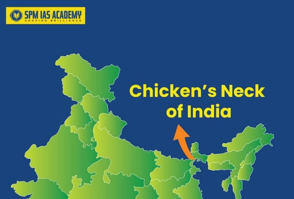
What is Chicken’s neck of India?
The Siliguri corridor is the popular strategic name for a narrow strip of land in North Bengal that links the Indian mainland to the Northeast. It connects Assam, Arunachal Pradesh, Manipur, Meghalaya, Mizoram, Nagaland, Tripura, and Sikkim with the rest of India.
This corridor is surrounded by sensitive international borders. Nepal lies to its west, Bhutan to its north, Bangladesh to its south, and the China-facing Chumbi Valley lies to its east and northeast. Because of this unique geography, the corridor sits at the centre of several geopolitical fault lines. As a result, it has become one of India’s most sensitive strategic zones.
Where Is Siliguri Corridor Located?
The Siliguri Corridor location is in the northern part of West Bengal. It stretches for roughly 200 kilometres through North Bengal.
What is the distance of this Siliguri corridor?
At its narrowest point, it is only around 20 to 25 kilometres wide, especially near Phansidewa and Panitanki close to the Nepal and Bangladesh borders. This narrow width creates a serious bottleneck.
Unlike a broad landmass, this corridor concentrates major transport and communication infrastructure into a compressed space. Highways, railway lines, energy links, and communication networks pass through this narrow belt. Consequently, even a limited disruption in this region can create large-scale consequences.
Why is Siliguri corridor Important for India?
It Connects Northeast India to the Mainland
The most obvious importance of the Siliguri corridor is that it is the only major land link between mainland India and the Northeast. Therefore, it is essential for the movement of people, goods, troops, fuel, and administrative supplies. If this corridor gets blocked, India’s direct land connectivity with the Northeast can come under severe stress.
It Is Vital for National Security
The corridor plays a central role in India’s eastern defence strategy. Since the Northeast India region shares borders with several countries, maintaining seamless connectivity is necessary for defence logistics and troop movement. Thus, the Siliguri Corridor holds immense military value.
It Supports the Act East Policy
The region is also important for India’s Act East Policy, cross-border trade, regional integration, and economic growth in the Northeast. Therefore, the corridor is not just a security route, it is also an economic and geopolitical gateway.
Geographic and Strategic Features of the Siliguri Corridor
The narrow structure of the corridor creates a classic chokepoint. In strategic studies, a chokepoint is a place where movement can be easily restricted or disrupted. The Siliguri Corridor fits this definition perfectly because it channels vital infrastructure through a very limited space.
Moreover, the region has a dense civilian population. This makes large-scale militarisation difficult because any security response must also consider civilian safety and collateral effects. At the same time, the restricted manoeuvre space can complicate force mobilisation during a major crisis.
Why Is the Siliguri Corridor Called a Vulnerable Chokepoint?
Narrow Width and Concentrated Infrastructure
The corridor’s narrow geography is its biggest weakness. India relies on a limited number of highways and railway links in this stretch. Therefore, any damage caused by conflict, sabotage, or natural disaster can halt connectivity and severely affect both civilian and military logistics.
Natural Disaster Risks
The region is prone to heavy rainfall and landslides. This means that vulnerability does not come only from foreign threats. Natural events can also affect supply lines and transport infrastructure. As a result, the corridor remains sensitive even during peacetime.
Multi-Domain Threat Environment
Modern threats are not limited to military attacks. Cyber operations, electronic warfare, intelligence surveillance, infiltration, trafficking, and smuggling can all complicate India’s security posture in the corridor. Therefore, the vulnerability of the Siliguri Corridor is military, economic, infrastructural, and technological at the same time.
Strategic topics like the Siliguri Corridor frequently appear in currentaffairs discussions for UPSC and APSC preparation.
China and the Siliguri Corridor: Why the Concern Is Serious?
China has long viewed the Siliguri Corridor as a potential pressure point in any wider conflict with India. The corridor lies close to the strategically sensitive Chumbi Valley near the India-Bhutan-China tri-junction. From elevated positions in the eastern Himalayas, the PLA could potentially threaten Indian infrastructure and logistics leading toward the corridor.
Moreover, China’s infrastructure buildup around Doklam and its broader regional presence as part of India’s strategic concern. In addition, improved Chinese road, rail, air, satellite, and UAV capabilities can increase surveillance over Indian movements in the area. Consequently, India sees the region as highly sensitive from a military and intelligence perspective.
Infrastructure Fragility in the Siliguri Corridor
One of the biggest risks in the Siliguri Corridor is overdependence on a small number of supply routes. The single railway connection to the Northeast and a few national highways are especially critical. If these are damaged, India could face severe disruptions in transport, military reinforcement, and civilian logistics.
This infrastructure fragility explains why the Chicken’s Neck is often described as India’s strategic Achilles’ heel. However, it is also the very reason why India has started investing in stronger defensive and connectivity measures.
Indian Measures to Protect the Siliguri Corridor/Chicken’s Neck
Military Deployment and Preparedness
India has built a layered defence system around the corridor. The Indian Army’s Trishakti Corps (33 Corps), headquartered at Sukna near Siliguri, is responsible for defending this region. It regularly conducts manoeuvres and readiness exercises. The Indian Air Force also operates from nearby bases such as Hashimara, while long-range strike systems like BrahMos add deterrent capacity.
Border Security and Surveillance
India has strengthened border management along the Bangladesh frontier through fencing, thermal cameras, night-vision systems, enhanced patrolling, and drone surveillance. Local restrictions on unauthorised drones and military-style clothing also show that India is trying to close small but important security gaps.
Air Defence and ISR Systems
To counter aerial and missile threats, India has deployed layered air defence systems in the eastern theatre, including the S-400, Akash, and MRSAM systems. At the same time, aerial and satellite-based surveillance helps improve situational awareness. Therefore, India is not relying on a single defensive tool. Rather, it is building a multi-layered shield.
Diplomacy with Neighbours
India also engages diplomatically with Nepal, Bhutan, and Bangladesh to reduce the risk of regional instability being exploited by external powers. This soft-security approach is as important as military preparation because stable neighbourhood relations reduce pressure on the corridor.
Underground Railway Project in the Chicken’s Neck
A major strategic idea India is implementing is the development of an underground railway line between Tin Mile Hat and Rangapani near Siliguri. The proposal reportedly involves burying the line at a depth of around 20 to 24 metres. The logic is straightforward: underground infrastructure is harder to disrupt through artillery, air attack, sabotage, or physical blockade.
Future of the Siliguri Corridor in India’s Defence Planning
The Chicken’s Neck of India will remain central to defence planning for decades. Its narrow geography cannot be changed. However, India can reduce vulnerability through better infrastructure, alternative connectivity, improved border management, stronger military readiness, and active diplomacy.
The long-term solution lies in building redundancy. This includes alternative routes, better agreements with neighbours, upgraded air bases, rapid reaction capabilities, and pre-positioned logistics stocks. Therefore, India’s approach must remain comprehensive rather than purely military.
Conclusion:
The Siliguri corridor of India is far more than a narrow strip of land. It is a strategic lifeline that connects mainland India with the Northeast and supports national security, logistics, diplomacy, and economic integration. At the same time, its narrow geography makes it one of India’s most vulnerable regions.
Therefore, understanding the importance of the Siliguri Corridor is essential for UPSC, APSC, and other State PCS exams. This topic helps candidates build strong concepts in Indian geography, internal security, international relations, and strategic affairs.
Source:
Frequently Asked Questions:
The Siliguri corridor of India, also known as Chicken’s Neck of India, is a narrow land strip. It connects mainland India to the Northeast. Therefore, it plays a critical role in national connectivity and security.
The Siliguri Corridor is strategically important because it is the only major land link to Northeast India. As a result, it supports troop movement, trade, communication, and national integration.
The Siliguri Corridor is located in North Bengal, West Bengal. Specifically, it lies between Nepal, Bhutan, Bangladesh, and China-facing regions, making it geopolitically sensitive.
The Chicken’s Neck is called a vulnerable chokepoint because of its narrow width and concentrated infrastructure. Consequently, even small disruptions can severely impact connectivity and security.
The Siliguri Corridor faces multiple threats, including geopolitical tensions, infrastructure fragility, and natural disasters. Moreover, external factors like regional instability and surveillance risks increase its vulnerability.