Geography is one of the most popular and well-regarded optional subjects in the UPSC Civil Services Mains Examination. Its scientific nature, conceptual clarity, and overlap with General Studies papers,especially in areas like environment, disaster management, and current affairs, make it a strategic choice for many aspirants. Whether you come from a science or humanities background, Geography offers a balanced mix of physical and human aspects, supported by maps, diagrams, and real-world relevance. With the right approach, it can be a high-scoring and manageable optional subject.
To score well in your optional subject, a clear understanding of the syllabus is essential. Below, you’ll find the detailed optional geography syllabus
Why Choose Geography Optional for UPSC?
1. Strong GS Overlap
Geography covers a wide range of topics that are integral to GS papers, especially:
GS Paper I: Indian and World Geography
GS Paper III: Environment, Disaster Management, Resource Distribution
This overlap saves time and effort by reinforcing concepts across papers.
2. Scientific and Conceptual Subject
Geography is grounded in logic and scientific principles. Topics like climatology, geomorphology, and economic geography require conceptual clarity rather than mugging up facts, making it ideal for analytical thinkers.
3. Scoring with Diagrams and Maps
Geography offers good scoring potential due to its objective nature. Answers enhanced with diagrams, flowcharts, and maps are often rewarded, as they reflect better understanding and presentation.
4. Useful in Essay and Interview
Geography themes frequently appear in the essay paper—e.g., urbanization, climate change, development vs. environment. A good grip over these issues is also helpful in the personality test (interview) stage.
5. Abundant Resources
The subject is well-documented with ample standard books, online resources, toppers’ notes, and coaching material available, making self-preparation feasible.
For guided preparation, consider UPSC coaching Centre Guwahati for mentorship, notes, and test series.
UPSC Geography Optional Syllabus
Paper- I : PRINCIPLES OF GEOGRAPHY
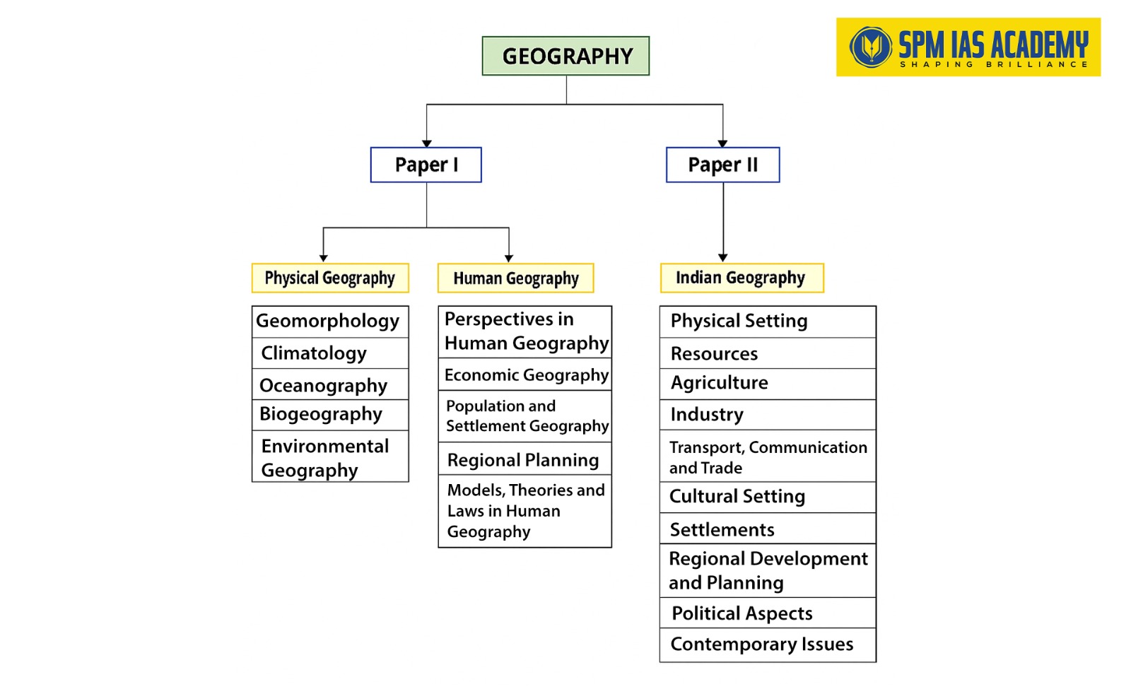
Physical Geography
- Geomorphology: Factors controlling landform development; endogenetic and exogenetic forces; Origin and evolution of the earth’s crusts; Fundamentals of geomagnetism; Physical conditions of the earth’s interior; Geosynclines; Continental drift; Isostasy; Plate tectonics; Recent views on mountain building; Volcanicity; Earthquakes and Tsunamis; Concepts of geomorphic cycles and Landscape development; Denudation chronology; Channel morphology; Erosion surfaces; Slope development; Applied Geomorphology; Geomorphology, economic geology, and environment.
- Climatology: Temperature and pressure belts of the world; Heat budget of the earth; Atmospheric circulation; Atmospheric stability and instability. Planetary and local winds; Monsoons and jet streams; Air masses and fronts; Temperate and tropical cyclones; Types and distribution of precipitation; Weather and Climate; Koppen’s Thornthwaite’s and Trewartha’s classification of world climate; Hydrological cycle; Global climatic change, and role and response of man in climatic changes Applied climatology and Urban climate.
- Oceanography: Bottom topography of the Atlantic, Indian, and Pacific Oceans; Temperature and salinity of the oceans; Heat and salt budgets, Ocean deposits; Waves, currents, and tides; Marine resources; biotic, mineral, and energy resources; Coral reefs coral bleaching; Sea-level changes; Law of the sea and marine pollution.
- Biogeography: Genesis of soils; Classification and distribution of soils; Soil profile; Soil erosion, Degradation, and conservation; Factors influencing world distribution of plants and animals; Problems of deforestation and conservation measures; Social forestry, agro-forestry; Wildlife; Major gene pool centers.
- Environmental Geography: Principle of ecology; Human ecological adaptations; Influence of man on ecology and environment; Global and regional ecological changes and imbalances; Ecosystem their management and conservation; Environmental degradation, management, and conservation; Biodiversity and sustainable development; Environmental policy; Environmental hazards and remedial measures; Environmental education and legislation.
Human Geography
- Perspectives in Human Geography: Areal differentiation; regional synthesis; Dichotomy and dualism; Environmentalism; Quantitative revolution and locational analysis; Radical, behavioral, human, and welfare approaches; Languages, religions, and secularisation; Cultural regions of the world; Human development index.
- Economic Geography: World economic development: measurement and problems; World resources and their distribution; Energy crisis; the limits to growth; World agriculture: a typology of agricultural regions; Agricultural inputs and productivity; Food and nutrition problems; Food security; famine: causes, effects, and remedies; World industries: location patterns and problems; Patterns of world trade.
- Population and Settlement Geography: Growth and distribution of world population; Demographic attributes; Causes and consequences of migration; Concepts of the over-under-and optimum population; Population theories, world population problems and policies, Social well-being and quality of life; Population as social capital. Types and patterns of rural settlements; Environmental issues in rural settlements; Hierarchy of urban settlements; Urban morphology; Concept of primate city and rank-size rule; Functional classification of towns; Sphere of urban influence; Rural-urban fringe; Satellite towns; Problems and remedies of urbanization; Sustainable development of cities.
- Regional Planning: Concept of a region; Types of regions and methods of regionalization; Growth centers and growth poles; Regional imbalances; regional development strategies; environmental issues in regional planning; Planning for sustainable development.
- Models, Theories and Laws in Human Geography: System analysis in Human geography; Malthusian, Marxian and demographic transition models; Central Place theories of Christaller and Losch; Perroux and Boudeville; Von Thunen’s model of agricultural location; Weber’s model of industrial location; Ostov’s model of stages of growth. Heartland and Rimland theories; Laws of international boundaries and frontiers.
Paper – II : GEOGRAPHY OF INDIA
- Physical Setting: Space relationship of India with neighboring countries; Structure and relief; Drainage system and watersheds; Physiographic regions; Mechanism of Indian monsoons and rainfall patterns; Tropical cyclones and western disturbances; Floods and droughts; Climatic regions; Natural vegetation, Soil types and their distributions.
- Resources: Land, surface and ground water, energy, minerals, biotic and marine resources, Forest and wildlife resources and their conservation; Energy crisis.
- Agriculture: Infrastructure: irrigation, seeds, fertilizers, power; Institutional factors; land holdings, land tenure and land reforms; Cropping pattern, agricultural productivity, agricultural intensity, crop combination, land capability; Agro and social-forestry; Green revolution and its socio-economic and ecological implications; Significance of dry farming; Livestock resources and white revolution; Aquaculture; Sericulture, Agriculture and poultry; Agricultural regionalisation; Agro-climatic zones; Agroecological regions.
- Industry: Evolution of industries; Locational factors of cotton, jute, textile, iron and steel, aluminum, fertiliser, paper, chemical and pharmaceutical, automobile, cottage, and ago-based industries; Industrial houses and complexes including public sector undertakings; Industrial regionalisation; New industrial policy; Multinationals and liberalisation; Special Economic Zones; Tourism including ecotourism.
- Transport, Communication, and Trade: Road, railway, waterway, airway, and pipeline networks and their complementary roles in regional development; Growing importance of ports on national and foreign trade; Trade balance; Trade Policy; Export processing zones; Developments in communication and information technology and their impacts on economy and society; Indian space programme.
- Cultural Setting: Historical Perspective of Indian Society; Racial linguistic and ethnic diversities; religious minorities; Major tribes, tribal areas, and their problems; Cultural regions; Growth, distribution, and density of population; Demographic attributes: sex-ratio, age structure, literacy rate, work-force, dependency ratio, longevity; migration (inter-regional, intraregional and international) and associated problems; Population problems and policies; Health indicators.
- Settlements: Types, patterns, and morphology of rural settlements; Urban developments; Morphology of Indian cities; Functional classification of Indian cities; Conurbations and metropolitan regions; Urban sprawl; Slums and associated problems; Town planning; Problems of urbanisation and remedies.
- Regional Development and Planning: Experience of regional planning in India; Five Year Plans; Integrated rural development programmes; Panchayati Raj and decentralised planning; Command area development; Watershed management; Planning for backward area, desert, drought-prone, hill tribal area development; Multi-level planning; Regional planning and development of island territories.
- Political Aspects: Geographical basis of Indian federalism; State reorganization; Emergence of new states; Regional consciousness and inter-state issues; International boundary of India and related issues; Cross-border terrorism; India’s role in world affairs; Geopolitics of South Asia and Indian Ocean realm.
- Contemporary Issues: Ecological issues: Environmental hazards: landslides, earthquakes, Tsunamis, floods and droughts, epidemics; Issues related to environmental pollution; Changes in patterns of land use; Principles of environmental impact assessment and environmental management; Population explosion and food security; Environmental degradation; Deforestation, desertification, and soil erosion; Problems of agrarian and industrial unrest; Regional disparities in economic development; Concept of sustainable growth and development; Environmental awareness; Linkage of rivers; Globalisation and Indian economy.
Aspirants can join UPSC coaching in north east India for region-focused support and quality guidance.
Previous year UPSC Questions
UPSC MAINS 2020 Paper-1
SECTION ‘A’
- Answer the following in about 150 words each:
a). Write a geographical note on Halloween Storm.
b). Why is mapping important for analysing geo-hydrological investigations? Explain with relevant examples.
c). Marine resources are economically very significant. Discuss citing suitable examples.
d). Which factors influence the growth of wild plants in India? Discuss their economic significance.
e). Discuss the problems associated with the living environment in million plus cities in India. How can these be managed? - Answer the following in about 150 words each:
a). Write an essay on the evolution of continents and oceans using various theories and models.
b). Discuss the concept of coral bleaching, its recovery and macroalgal regime shifts due to this process.
c). Explain the currents of the North Atlantic Ocean and their significant role in the climate of Western Europe. - Answer the following in about 150 words each:
a). Explain how various factors influence the origin and development of the Indian monsoon system.
b). Explain the effects and causes of deforestation, and its impact on the pattern of agriculture in India.
c). Explain the characteristic features of Frontogenesis and Frontolysis. - Answer the following in about 150 words each:
a). Discuss the problems of erosional surfaces and explain the different methods to identify them with suitable diagrams.
b). Land use/ Land cover and soil types influence forage quantity and quality in semi-arid regions of the world. Discuss with relevant examples.
c). Discuss the human response to and management of hazards and disasters in India.
SECTION ‘B’
- Answer the following in about 150 words each:
a) Analyse India’s food security in the context of population growth.
b) Identify the causes and effects of the energy crisis, and suggest suitable measures to solve the problem.
c) Distinguish between mobility and migration. What are the causes and consequences of rural to urban migration in India?
d) “Where economic growth is sustained over long time periods, its incidence works towards a progressive integration of the space economy.” Elucidate.
e) Write a note on the relevance of von Thünen’s agricultural location theory in the present context. - Answer the following:
a) Compare and contrast the Malthusian and Neo-Malthusian perspectives in the context of population growth, resource use and environmental impact.
b) “Land degradation is a threat to productivity and sustainable resource management.” Explain with suitable examples from India.
c) In the modern world, most of the frontiers have been replaced by boundaries. Explain the reasons. - Answer the following:
a)Discuss the concept of urban resilience in the context of planning for sustainable development with reference to towns and cities of India.
b) Analyse the dynamics of industrial location in the metropolitan cities of India.
c) Write an essay on gender equity and equality in India in the context of balanced human development. - Answer the following:
a) Discuss how and why Mackinder modified his concept of Pivot Area after the World Wars.
b) Provide an account of world population transition in the context of fertility decline and socio-economic development.
c) “Human ecology is the study of the mutual relationship of people and their environment both natural and social.” Discuss in detail using ecological concepts.
UPSC MAINS 2020 Paper-2
SECTION ‘A’
- Answer the following:
a) On the outline map of India provided to you, mark the location of all of the following. Write in your QCA Booklet the. significance of these locations whether physical/commercial/economic/ecological/environmental/cultural, in not more than 30 words for each entry :
(i) Vadhawan
(ii) Salkhan
(iii) Coorg
(iv) Mhow
(v) Umroi
(vi) Thoothukudi
(vii) Bargarh
(viii) Atal Tunnel
(ix) Gurushikhar
(x) Bum La
b). Climate change has unsettled the rhythm of seasons. Comment with examples and empirical evidence.
c). Discuss the methods of crop residue management in rural India to reduce pollution.
d). Has the regional aspiration of the people of Jammu and Kashmir been addressed through re-organisation of the state? Make an assessment. - Answer the following:
a) identify the areas covered under tribal sub-plan, discuss the programmes initiated to address their problems.
b) soil types in India, classified on the basis of colour, possess specific chemical and mineral characteristics. Discuss.
c) The pharmaceutical industry in India depends on the import of raw materials. Evaluate this statement in the view of Indo-Chinese relationship. - Answer the following:
a) India has opened its space to the private sector for satellite based activities. Critically examine its implications indicating the major security concerns.
b) Identify oilseeds producing areas in India and discuss the measures to promote edible oil industry.
c) Give a reasoned geographical account of changing rural folk houses in India. - Answer the following:
a) Border area development is an important national priority. What are the resilient steps needed for peaceful borders?
b) stunting and wasting among children are major consequences of food insecurity. Discuss various schemes of the Government of India to address these problems and their achievements.
c) the essential Commodities (Amendment) Bill 2020 aims to deregulate the production, supply and distribution of farm produce. Critically examine its spatial consequences.
SECTION ‘B’
- Answer the following in about 150 words each:
a). The success of Panchayati Raj depends upon meaningful participation of people at grassroot level. Examine
b). Elucidate the benefits of neem coated urea scheme for Indian agriculture.
c). Canal irrigation has led to monocropping in India. Explain with suitable examples.
d). The pattern of growing ecological footprints is uneven in nature. Analyse with reference to land resources in India.
e). Identify challenges faced by generative and parasitic towns in India and their possible remedies. - Answer the following:
a). Digital Divide in India needs quick redressal to reduce regional disparity in development. Elaborate with suitable examples.
b). Avalanche is a major hazard in the Himalayas. What are its causes and mitigation measures?
c). The process of demographic transition is not uniform in India. Examine this statement in the context of demographic transition theory. - Answer the following:
a). Demarcating the seismic zones of India, suggest suitable interventions required in most sensitive seismic zones for sustainable human settlements.
b). What are the characteristics of Blue Flag certified beaches? Discuss their significance for beach tourism in India.
c). Urban sprawl around planned cities evolve leading to emergence of squatter settlements. Discuss the advantages and disadvantages of such outgrowth. - Answer the following:
a). Analyse the changing nature of workforce composition vis-å-vis rural-urban divide in India.
b) Describe the economic, maritime and strategic interests of India in the South China Sea.
c) What kind of skill promotion programmes have been initiated for job deficient regions in India? Explain.
UPSC MAINS 2021 Paper-1
SECTION ‘A’
- Answer the following in about 150 words each:
a) Describe the concept of ‘Altiplanation’.
b) What are the important factors responsible for air mass modifications?
c) Discuss the hazards associated with rise of sea-surface temperature,
d) Gene pool centres are ‘Good Hope’ for biodiversity conservation. Elucidate.
e) Describe how ecosystem services of Himalayas are essential for Highland-Lowland sustainability in Asia. - Answer the following:
a) The concept of Plate tectonics has been derived from the isostasy and continental drift theory. Elaborate citing suitable examples.
b) Give a detailed account of the bottom topography of the Pacific Ocean.
c) Soil erosion and soil degradation are a threat to food supply. Discuss. - Answer the following:
a) Examine major influencing factors for varied patterns of precipitations on the continents.
b) Maritime security is being neglected. Indicate the major challenges and suggest solutions in the context of Law of the Sea.
c) Explaining the concept of carbon neutrality, describe the measures taken by carbon positive and negative nations. - Answer the following:
a) With suitable examples, elaborate human ecological adaptations. Explain its impacts on ecology and environment in various parts of the world.
b) Stream basins and drainage divides are important components to delineate a watershed area. Explain.
c) Indicating the causes of lightning, describe the threats associated with it.
SECTION ‘B’
- Answer the following in about 150 words each:
a). The interrelationships between social and spatial structure are complex. Explain in the context of socio-spatial dialectic.
b). How is energy transition seen as an instrument for achieving zero carbon by 2050?
c). Protected cultivation assists in healthier and larger produce. Justify with examples.
d). Explain the processes of contagion and hierarchical diffusion in addressing regional imbalances.
e). Examine the relevance of Central Place Theory of Christaller in the present context. - Answer the following:
a). Development-induced displacement poses serious challenges. Mention its causes, consequences, and solutions.
b). Describe the role of accessibility and affordability in food security of the developing world.
c). The environmental issues are not adequately addressed in the regional planning. Comment. - Answer the following:
a). Suggest criteria, indicators and techniques for delimitation of formal regions.
b). Boundaries are important in geopolitics. Explain. What issues develop from the inclusionary and exclusionary aspects of borders?
c). A small number of mega cities are playing a key role in the organisation of global economics and culture. Explain. - Answer the following:
a). Why is radicalism seen as a major paradigm shift in geography? Explain its causes, approaches and criticism.
b) An aging population has adverse social and economic consequences. Explain with examples.
c) Present a critical account of Alfred Weber Theory of industrial location.
UPSC MAINS 2021 Paper-2
SECTION ‘A’
- Answer the following:
a). On the outline map of India provided to you, mark the location of all the following. Write in your QCA Booklet the significance of these locations whether physical / commercial / economic / ecological / environmental / cultural, in not more than 30 words for each entry.
(i) Ziro Valley
(ii) Khecheopalri Lake
(iii) Toranmal
(iv) Subarnarekha River
(v) Koderma
(vi) Sir Creek
(vii) Periyar Wildlife Sanctuary
(viii) Peechi Dam
(ix) Digha Beach
(x) Pamban Island
b). Discuss the geo-political impact of bilateral relationship between India and Bhutan.
c). Discuss the economic significance of volcanic soils of India.
d). Give a reasoned account of the difference between the sugar industry of North and Peninsular India. - Answer the following:
a). Landslides are a major problem in Himalayan region. Discuss its causes and mitigation measures.
b). Appraise why drought is one of the most common climatic extremes in India.
c). Discuss the ecological and economic challenges of river linking in India. - Answer the following:
a). Discuss the importance of solar energy in future economic development of India.
b). Critically examine the importance of Smart Cities Programme for solving urban problems in India.
c). Examine the significance of ecotourism in relation to socio-economic development and biodiversity conservation in India. - Answer the following:
a). Discuss the reserves, distribution and production of all varieties of coal in India.
b). Describe the salient features of east-flowing rivers of India.
c). Critically examine the problems of inter-State border disputes in India.
SECTION ‘B’
- Answer the following in about 150 words each:
a). Discuss the salient features of Project Tiger in India.
b). Describe the problems of cloud burst in India giving suitable examples.
c). Discuss the role of watershed management for soil and water conservation in hilly regions of India.
d). Critically examine the relevance of Ravenstein’s law of population migration with reference to India.
e). Discuss Ashok Mitra’s classification method of Indian cities. - Answer the following:
a). Explain the impact of tropical cyclones and western disturbances on the climate of India.
b). Examine the critical issues of groundwater resources in India.
c). Describe the structure and relief features of the Deccan Plateau. - Answer the following:
a). Critically examine how the Panchayati Raj system is a catalyst in decentralized planning in India.
b). Identify the major industrial corridors of India and discuss the characteristics of Bengaluru—Mumbai Corridor.
c). Assess the growth of multinational corporations in the liberalized economic environment of India. - Answer the following:
a). Examine how information and communication technology has boosted the development of certain regions of India.
b). Discuss the Command Area Development Programme and its impact on eliminating regional inequalities in India.
c). Critically assess the status of balance of trade in India and suggest some measures to combat the issues.
| 2024 Geography Optional Paper | |
| 2024 Geography Optional Paper- 1 | 2024 Geography Optional Paper- 2 |
| 2023 Geography Optional Paper | |
| 2023 Geography Optional Paper- 1 | 2023 Geography Optional Paper- 2 |
| 2022 Geography Optional Paper | |
| 2022 Geography Optional Paper- 1 | 2022 Geography Optional Paper- 2 |
| 2021 Geography Optional Paper | |
| 2021 Geography Optional Paper- 1 | 2021 Geography Optional Paper- 2 |
| 2020 Geography Optional Paper | |
| 2020 Geography Optional Paper- 1 | 2020 Geography Optional Paper- 2 |

Behind every article at SPM IAS Academy is a team of skilled content writers and subject experts committed to making preparation easier for aspirants. From answering common doubts to breaking down complex issues and current affairs, we create content that is accurate, easy to understand, and directly useful for UPSC, APSC, and other competitive exams.