Meghalaya is one of the seven northeastern states of India, and Shillong serves as its capital. The British gave Shillong the nickname “Scotland of the East” because its cool climate, green hills, waterfalls, and lakes reminded them of their homeland.
On 21 January 1972, India carved out the Khasi Hills, Jaintia Hills, and Garo Hills from Assam to form the new state of Meghalaya. The state showcases stunning landscapes with mountains, valleys, hills, and plateaus, making it one of the most scenic regions of India.
Origin of the Name Meghalaya
Who is credited for coining the term Meghalaya?
The Indian geographer Professor S. P. Chatterjee is credited for coining the term “Meghalaya” in 1936. Derived from Sanskrit, the name ‘Meghalaya” means in English is“abode of the clouds.”. Mr. Chatterjee originally used it for the Shillong Plateau, drawing a parallel with Himalaya (“abode of snow”). The term was later adopted officially when Meghalaya became an autonomous state in 1970 and attained full statehood in 1972.
Key Facts for UPSC
- Credited with coining: Prof. S. P. Chatterjee (1936)
- Meaning: Abode of clouds (Sanskrit)
- Initial use: Describing the Shillong Plateau
- Adoption: Autonomous state (1970), Full statehood (1972)
Ancient and Pre-Colonial History of Meghalaya
Present-day Meghalaya reflects a microcosm of diversity, shaped by centuries of migration. The Pnars, Khasis, and Garos, who belong to the Paleo-Mongoloid group, are regarded as some of the earliest settlers of Northeast India. The Achiks or Garos, belonging to the Tibeto-Burman language family, share close ethnic ties with the Bodos of Assam, while the Khasis and Pnars trace their origins to the Mon-Khmer family.
However, pre-colonial references to the Pnars appear in records of the Ahom kingdom (in present-day Assam). Traditionally, the three main tribal groups—the Khasis, Garos, and Jaintias— inhabited the mainland. They maintained their own distinct systems of governance. Further, the Khasis organized small kingdoms known as syiemships, ruled by chiefs called syiems. In addition, the Garos followed a decentralized structure, with authority vested in local village headmen called nokmas. In contrast, the Jaintias developed a more centralized kingdom, with Jaintiapur (now in Bangladesh) as their capital.
The Jaintia kingdom controlled important trade routes by trading limestone with the Nawab of Bengal. A striking cultural feature of the Jaintia and other societies was their matrilineal system, where property and clan identity passed through women. This system ensured that lineage continued smoothly from one generation to the next.
Meghalaya under Colonial rule
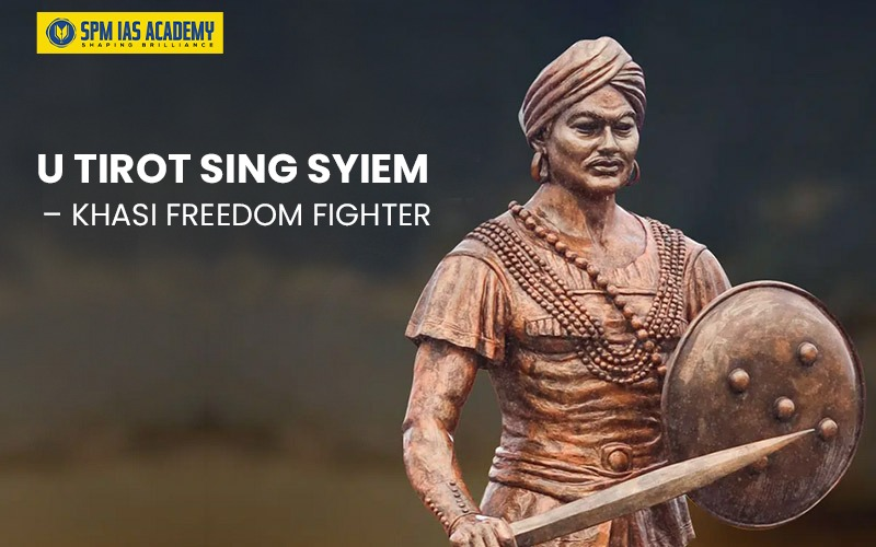
Apart from references to the major Khasi kingdoms in the chronicles of the Ahoms and Kacharis, little is known about Meghalaya’s early history before the British period. Furthermore, in the early 19th century, the British sought to construct a strategic road linking Bengal and Assam. As a result, it led to the Treaty of 1827 with the syiem (ruler) of Nonkhlaw, U Tirot Sing Syiem. At first, U Tirot Sing allowed the road, but soon many people opposed it. However, in 1829, he changed his decision and attacked the British. This sparked a prolonged conflict between the Khasi warriors and the British soldiers. U Tirot Sing used guerrilla warfare (fighting from forests and hills) to resist them. But the British were stronger, and by the 1830s, most Khasi chiefs had surrendered. The Britishers captured U Tirot Sing and sent to jail in Sylhet, where he died in 1835. For the next century, the British controlled what they called the Garrow and Cossiya (Khasi) States, but they largely allowed the tribes to live in seclusion and continue their traditional way of life.
After Independence in 1947, the rulers of the region acceded to India. Prime Minister Jawaharlal Nehru evolved a policy of protecting tribal identity through special constitutional provisions. Thus, though included within Assam, the region retained autonomy.
When the government made Assamese the official state language in 1960, the people of Meghalaya intensified their demands for self-rule. Unlike in many other parts of the Northeast, this agitation was peaceful and constitutional. As a result, Meghalaya became an autonomous state within Assam in 1970 and achieved full statehood on January 21, 1972.
Formation of Meghalaya: Journey to Statehood
Not to mention that after India gained independence in 1947, Meghalaya was part of Assam. Further, to protect the tribal way of life, the government set up the Khasi Hills Autonomous District Council (KHADC) and the Garo Hills Autonomous District Council (GHADC) on 27 June 1952 under the Sixth Schedule of the Constitution.
In 1960, the Assam government made Assamese the official language, which upset the people of the Khasi, Jaintia, and Garo Hills. They feared their culture and language would be ignored. As a result, this led to a peaceful movement for a separate state.
In 1969, the Assam Reorganisation (Meghalaya) Act gave Meghalaya the status of an autonomous state within Assam. But the demand for full statehood continued. Finally, with the North-Eastern Areas (Reorganisation) Act, 1971, Meghalaya became the 21st state of India on January 21, 1972, with Shillong as its capital.
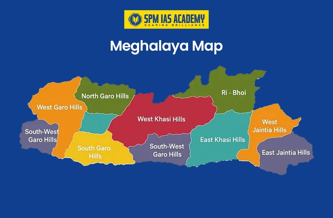
Geographical Location of Meghalaya
Figure showing the Geographical location of Meghalaya in a map along with its neighbouring states.
The key aspects of Meghalaya’s geographical location are:
Location: Meghalaya is situated in the northeastern region of India, often referred to as the “Seven Sister States,” along with Assam, Arunachal Pradesh, Mizoram, Nagaland, Tripura, and Sikkim
Borders of Meghalaya
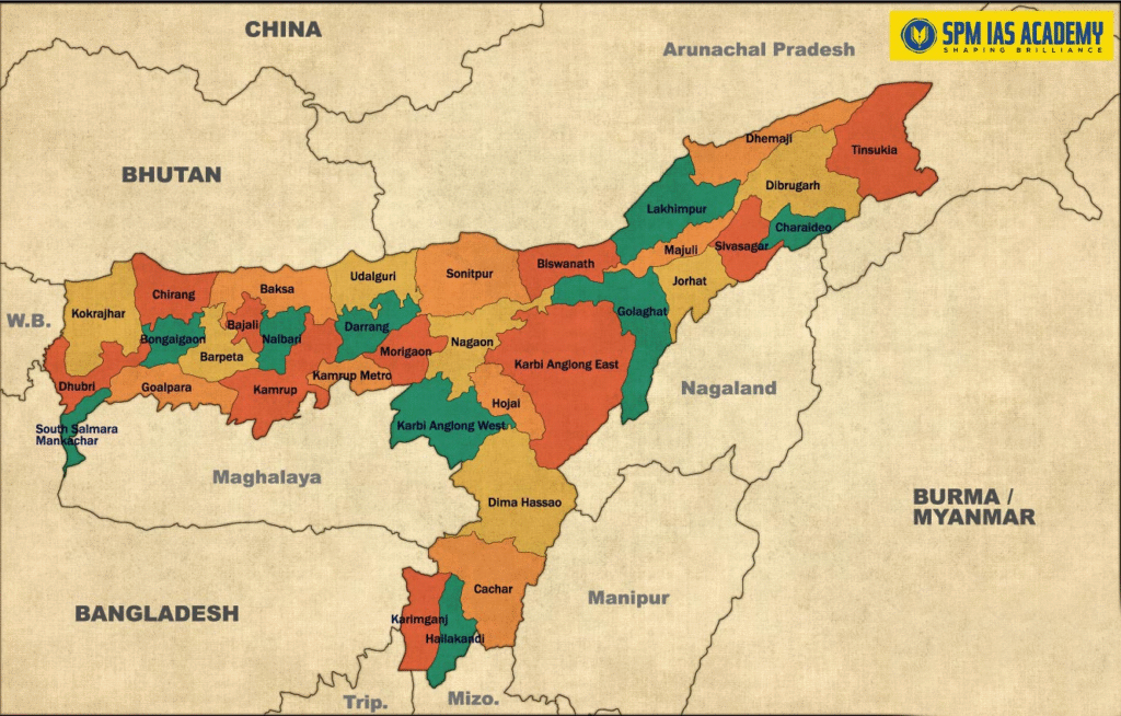
Figure showing Meghalaya sharing a border with Assam and Bangladesh.
North and east: Markedly, Meghalaya shares an approximately 884.90-kilometer border with Assam in its North and East direction. The districts of Assam that share land with Meghalaya are
| Assam District | Border Length with Meghalaya (Km) |
| Kamrup (M) | 79.70 |
| Kamrup | 200.90 |
| Goalpara | 169.80 |
| Dhubri | 15.18 |
| South Salmara Mankachar | 98.32 |
| West Karbi Anglong | 162.10 |
| Morigaon | 14.50 |
| Cachar | 19.50 |
| Dima Hasao | 124.90 |
South and west: In particular, Bangladesh and Meghalaya share a 443 km international boundary, and it is the fifth-longest international border in the world.
Location of Meghalaya:
Meghalaya lies between 25°1′ to 26°5′ North latitude and 89°45′ to 92°47′ East longitude
Area of Meghalaya:
Meghalaya has a total geographical area of 22,429 square kilometers (km²). For the most part, this area constitutes 0.68% of India’s total geographical area. Consequently, making it one of India’s smaller states
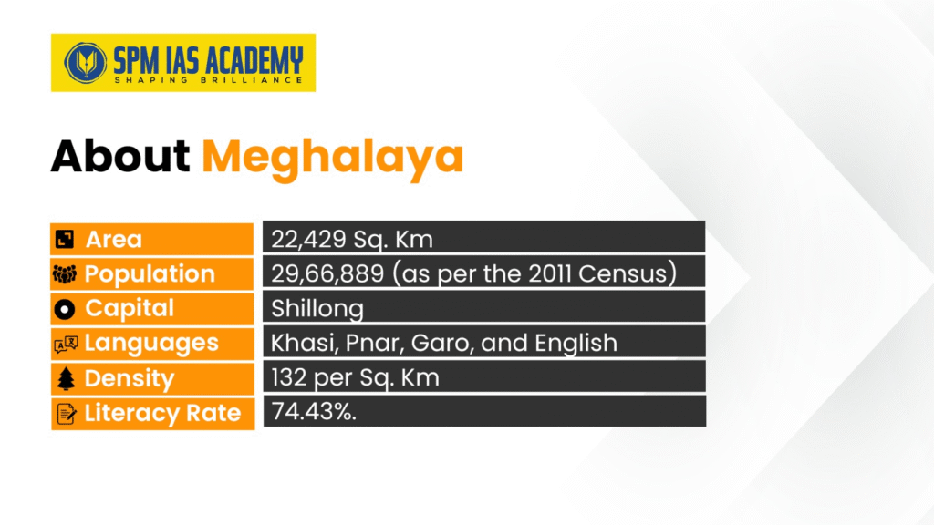
Capital and Major Cities:
- Capital: Shillong (also known as the “Scotland of the East”)
- Other important towns include Tura, Cherrapunji, and Mawsynram
Topography of Meghalaya:
It has varied topography characterized by many key features such as steep valleys, rolling grasslands, thick forests, cliffs, deep gorges, ancient caves and plateaus, and high hills.
- Plateau Structure Meghalaya is a part of the Deccan Plateau. On the whole, it is a part of the supercontinent of Gondwana land and is structurally a part of the Chhotanagpur Plateau, separated by the Malda Fault.
- Elevation: The state is at considerable elevation, ranging from 150 to 1,800 meters above sea level. In brief, the plateau gradually slopes from south to north, with the highest elevations in the south.
Major Hills and Ranges of Meghalaya
The plateau is divided into three main hill ranges:
- Garo Hills in the western part (highest peak: Nokrek at 1,412m)
- Khasi Hills in the central region (highest peak: Lum Shyllong at 1,965m)
- Jaintia Hills in the eastern section (highest peak: Lum Pohskor)
Geological Composition of Meghalaya
The region is predominantly composed of Archean rock formations, including gneiss, schist, and granite. There are also significant coal deposits and limestone formations, particularly in the Jaintia Hills.
Drainage and Valleys of Meghalaya
Numerous rivers originate from the plateau, flowing both north toward the Brahmaputra and south toward Bangladesh. Deep valleys and gorges cut through the plateau, creating a dissected landscape with steep slopes and narrow valleys.
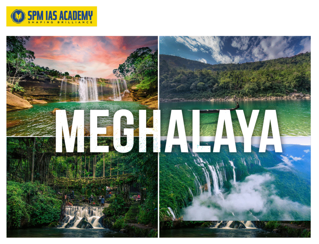
Unique Features of Meghalaya
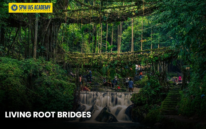
Meghalaya has some of the unique features, such as living root bridges it is a natural bridges formed from living tree roots. Cherrapunji and Mawsynram receive the highest amount of annual rainfall, approximately 11,837 millimeters ( 467.4 inches), making it the wettest place on Earth.
In addition, Meghalaya has extensive cave systems, indigenous tribal cultures of Garo, Khasi, and Jaintia, adding to its rich cultural heritage.This diverse topography contributes to Meghalaya’s rich biodiversity and distinct climatic zones across different elevations, ranging from about 150 meters above sea level.
Rivers of Meghalaya
In essence, Meghalaya, the “abode of clouds”, lies on a mountainous plateau in Northeast India, bounded by Assam in the north and northeast, and Bangladesh in the south and southwest. For the most part, receiving nearly 1,140 cm of rainfall annually, the state is home to numerous rain-fed rivers, many of which form deep valleys, gorges, and waterfalls.
The river systems can be broadly divided into three regions:
- Garo Hills: Simsang (Someshwari), Ganol, Dareng, Nitai, Bandra.
- Central & Eastern Plateau: Umtrew, Umngot, Umngi, Myntang, Umami (Barapani), Jadukata.
- Khasi Hills (Southern slopes): Rivers here form spectacular waterfalls and canyons before flowing into Bangladesh.
Key Rivers:
- Digaru River: Known as Umtru, meaning “water of the Garos”. It joins the Kopili and ultimately the Brahmaputra. Important dams – Umtru, Kyrdemkulai, Nongkhyllem.
- Kopili River: Largest river of Meghalaya and major south-bank tributary of the Brahmaputra; length ~290 km, catchment ~16,420 sq km.
- Myntdu River: Flows through Jowai, provides irrigation, hydropower potential; flows south into Bangladesh.
- Someshwari (Simsang) River: Largest river of Garo Hills, second largest in the state; flows through Williamnagar, Baghmara, and Rewak into Bangladesh.
- Umngot River: Famous crystal-clear river near Dawki; a tourism hotspot and trade route with Bangladesh.
Due to its heavy rainfall and plateau geography, Meghalaya has a dense network of rain-fed rivers that are crucial for irrigation, hydropower, and cross-border trade, besides shaping its unique landscape and boosting tourism.
Distinctive Features
- Seasonal Flow Patterns: Most rivers are rain-fed and experience dramatic seasonal variations, with peak flow during the monsoon months (June-September).
- Waterfalls and Rapids: The plateau topography creates numerous spectacular waterfalls, including the famous Nohkalikai Falls and Seven Sisters Falls.
- Underground Drainage: The limestone-rich Jaintia Hills have extensive cave systems and underground rivers, creating unique karst topography.
- Border Rivers: Many rivers form natural boundaries with Bangladesh, Assam, and other neighboring states.
Lakes of Meghalaya
Altogether, Meghalaya, in Northeast India, is known for its highlands, rivers, waterfalls, forests, wildlife sanctuaries, caves, and sacred groves, which collectively boost tourism. Its lakes also contribute to the state’s ecological and tourism value.
1. Umiam Lake (Barapani/Big Water)
- Location: 15 km north of Shillong.
- Type: Artificial lake/reservoir created by damming the Umiam River.
- Significance: Significantly, the First hydel power project in Northeast India supports power generation, irrigation, fisheries, and drinking water.
- Activities: Kayaking, boating, water cycling.
- Issues: Pollution from urban waste, siltation (~40,000 m³/year), deforestation, upstream encroachments, and unscientific mining.
2. Umhang Lake
- Location: Batow village, Jaintia Hills.
- Significance: Considered sacred by locals; annual rituals offered.
- Features: Surrounded by dense forests; historical formation by Chieftain U Sajar Nangli.
3. Thadlaskein Lake
- Location: ~56 km from Shillong.
- Significance: Historical lake built by followers of U Sajar Nangli; used for picnics and boating.
4. Wards Lake (Pollock’s Lake)
- Location: Shillong.
- Type: Artificial lake.
- Features: Home to colorful fish, with a wooden bridge and boating facilities.
The lakes of Meghalaya, both natural and artificial, are important for tourism, culture, and local ecology, while some face environmental challenges like pollution and siltation, highlighting the need for sustainable management.
Hydropower projects in Meghalaya
Another key point is that the river system is important for hydroelectric power generation. Given these points, some of the important hydroelectric plants are given below.
| Sl no. | Name | District | Basin | River |
| 1 | Myntdu Leshka Stage-I | Jaintia Hills | Brahmaputra | Myntdu |
| 2 | Umiam Hydroelectric Project | Ri bhoi | Brahmaputra | Umiam |
| 3 | Umiam-Umtru Hydroelectric Project | Brahmaputra | Umtru | |
| 4 | Umtru Hydroelectric Project | Khasi Hills | Brahmaputra | Umtru |
Mountain Passes of Meghalaya
The Garo, Khasi, and Jaintia Hills are part of the older Peninsular Block, not the younger Himalayan mountain system, so Meghalaya does not have high mountain passes; rather, it has natural corridors and low mountain passes through the hills.
- Dawki Pass – a key trade route with Bangladesh, near the Umngot River.
- Mawkdok Dympep Pass – a gorge on the way to Cherrapunji.
Dams in Meghalaya
The Dams are created for irrigation purposes, the generation of hydropower, and many other purposes. Some of the important Dams are:
| SL NO. | Dams Name | District |
| 1 | Umiam Dam (Barapani Dam) | Shillong |
| 2 | Mawphlang Dam | Shillong |
| 3 | Myntdu Dam | Jaintia Hill |
National Parks and Wildlife Sanctuaries in Meghalaya
National Park of Meghalaya
Mainly, there are two national parks in Meghalaya:
- Balpakram National Park – located in South Garo Hills, known for its dramatic landscape, gorges, and major species found are Bengal Tiger, Asiatic Elephant, Asian Golden Cat, and the endangered Red Panda
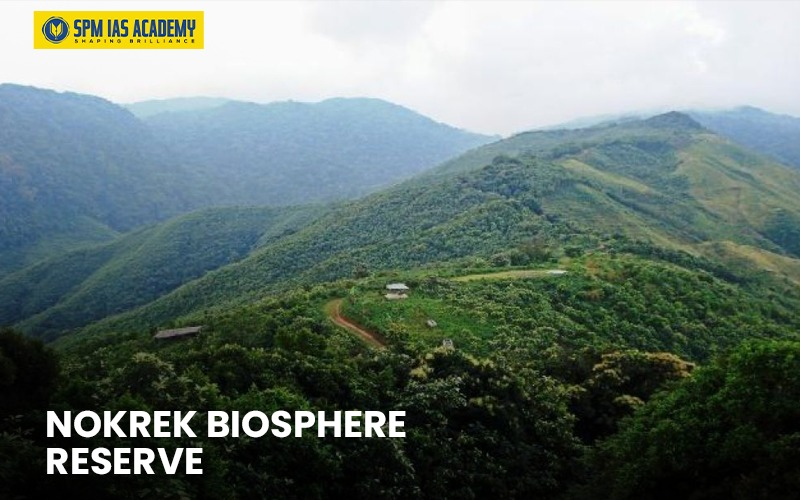
- Nokrek National Park – Nokrek National Park is located in the Garo Hills region, near the city of Tura. It is home to endangered species such as the Red Panda and the Hoolock Gibbon.
Wildlife Sanctuaries of Meghalaya
As a matter of fact, the protected area in Meghalaya occupies 1133.9 Sq Km, which constitutes about 5.06% of the State’s Geographical Area. By the same token, the Protected Area Network includes 2 national Parks, 4 wildlife Sanctuaries, and 1 Biosphere Reserve. The wildlife sanctuaries include:
- Siju Wildlife Sanctuary – Covers only 5.18 Sq. Kms and it is known for animals such as Elephants, Barking Deer, Sambar Deer, Wild Boar, Tiger, Clouded Leopard
- Baghmara Pitcher Plant Sanctuary – Significantly, the only Sanctuary in Meghalaya where in-situ conservation of Pitcher Plant is being carried out.
- Nongkhyllem Wildlife Sanctuary – Located in Ri Bhoi District. It is indeed known for its rich biodiversity and endangered Rufous-necked Hornbill and Clouded Leopardit. Further, characterized by dense subtropical forests and the natural Birbah lake.
- Narpuh Wildlife Sanctuary – Located in Jaintia Hills, and is known for its diverse biodiversity, including threatened species like the Rufous-necked Hornbill and Tawny-breasted Wren-babbler.
Biosphere Reserve in Meghalaya:
In fact, it has only one biosphere reserve, i.e, the Nokrek Biosphere Reserve. Certainly, this reserve plays a vital role in the in-situ conservation of biodiversity, and its unique conservation of citrus plants and diverse wildlife.
Culture of Meghalaya:
The first thing to remember is that the state of Meghalaya is rich and unique in its culture and tradition. In general, the major tribal groups of Meghalaya, the Garo, Khasi, and Jaintia, have their own language, culture, and social practices. By the same token, Shillong, the homeland of the three indigenous hill communities—the Khasi, Jaintia, and Garo—presents a rich mosaic of cultures that have coexisted harmoniously for centuries. However, the majority of Shillong’s population belongs to the Khasi tribe, who are predominantly Christian by faith. In addition, the influence of Christianity and the work of missionaries has left a lasting impact on the region, with nearly half of Meghalaya’s population adhering to the Christian religion.
Explicitly, the term Khasi is believed to derive from Ka Shi, meaning “the first woman of the society.” In the Khasi language, Ka denotes the feminine gender, while Shi signifies one. On the whole, reflecting this matrilineal tradition, many clans of the Khasi community trace their lineage through narratives of descent from the mother.
It’s important to realize that hospitality forms an integral part of Khasi culture. On balance, a guest visiting a Khasi household is traditionally welcomed with Kwai, a preparation of betel nut offered as a symbol of friendship and goodwill. By the time, this is often accompanied by homemade rice beer, reflecting warmth, respect, and the spirit of community bonding.
Art and Craft of Meghalaya
To begin with, Meghalaya has a rich tradition of art and crafts that reflect the cultural heritage and have their own uniqueness.
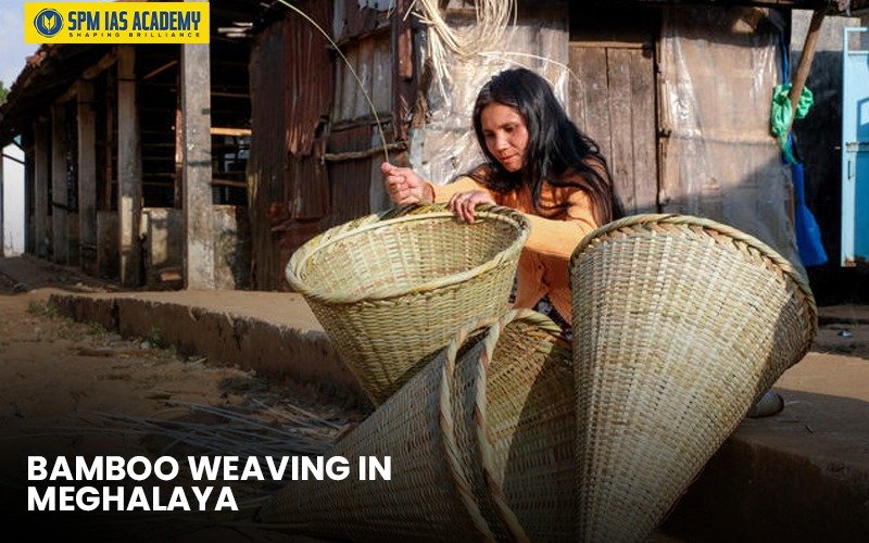
- Bamboo Weaving in Meghalaya:
Straightaway, Cane and bamboo product making is one of the prime occupations of the tribal people of Meghalaya. Especially, the three tribes of Meghalaya, the Garos and the Khasis, weave cane mats, stools, and baskets. Explicitly, they make a special kind of cane mat called ‘Tlieng’, and the Jaintias are adept at making different kinds of cane and bamboo products.
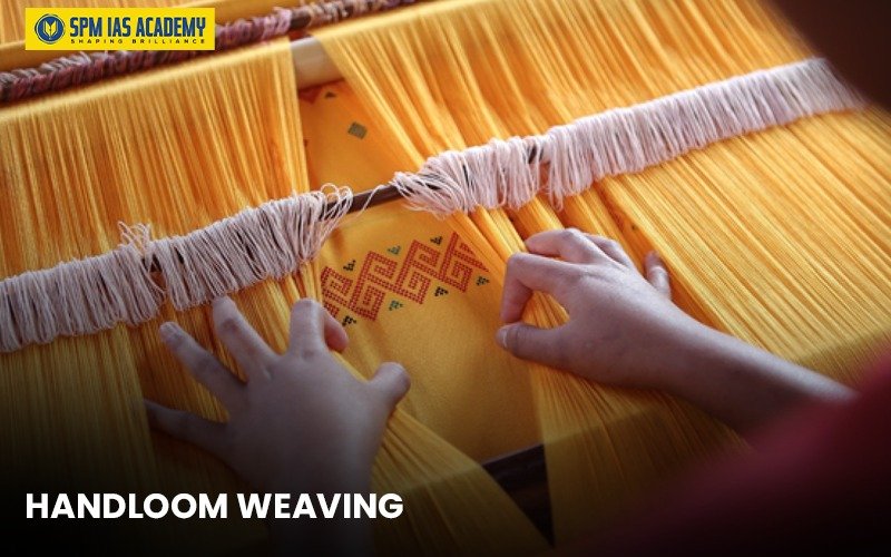
- Handloom Weaving
Markedly, weaving is an ancient craft of the tribes of Meghalaya. Moreover, each tribe has distinctive weaving traditions. The Khasis are known for their colorful shawls and traditional dresses, while Garo weavers create beautiful textiles with geometric patterns. Besides, the Jaintias produce fine cotton and silk fabrics.
Tribes of Meghalaya
In general, a tribe is a group of people who share a common language, customs, traditions, and beliefs. Correspondingly, tribes often live in their own villages and follow unique cultural practices. For instance, Meghalaya is home to many tribes, each with its own history and lifestyle.
Khasi People
- The Khasis mainly live in Meghalaya, with some also in Bangladesh.
- According to Khasi mythology, they came from Hynniewtrep, meaning “seven huts.”
- They speak the Khasi language, which belongs to the Austro-Asiatic family.
- Traditional dresses: Jymphong (men), Jainsem/Dhara (women).
- They are known for making living root bridges and growing betel leaf, areca nut, and oranges.
- They follow a matrilineal system, where property passes through the mother’s line.
Garo People
- The Garos, also called A-Chick Mande (hill people), are the second largest tribe in Meghalaya.
- They mostly follow Christianity, though many old traditions and worship of deities remain.
- Their language belongs to the Tibeto-Burman family.
- They also follow a matrilineal system.
- Main festivals: Wangala, Gal-mak Doa, Agalmaka, and Christmas.
- Many Garos also live in Assam, Nagaland, and Bangladesh.
Hajong People
- The Hajongs are the fourth largest tribe in Meghalaya and are also found in Assam and Bangladesh.
- They speak the Hajong language, an Eastern Indo-Aryan language.
- Traditional dress: Pathin and Phula Agon (women).
- Festivals: Durga Puja, Nongtang, Chormaga, and others.
- They follow a mix of Hinduism and animistic practices.
Pnar or Jaintia People
- Also called Synteng, they are linked to the old Jaintia Kingdom, annexed by the British in 1835.
- Their name comes from Ki Hynniew Trep (seven families).
- In 1972, the Jaintia Hills District was formed.
- Their traditional religion is called Niamtre.
Tiwa People
- The Tiwas, also known as Lalungs, live in Assam and Meghalaya.
- They are divided into Hill Tiwas (matrilineal, live in Ri-Bhoi & Karbi Anglong) and Plain Tiwas (live in Assam, speak Assamese).
- Their language belongs to the Bodo-Garo group of Tibeto-Burman family.
- Population: about 1.7 lakh (2001 Census).
Dance and Music of Meghalaya
Meghalaya, often called the “abode of clouds,” is not only blessed with natural beauty but also with a vibrant cultural life. The state is home to three major tribes—the Khasi, Jaintia, and Garo—who live together in harmony, each adding their own flavor of traditions, dances, and music.
Music Traditions of Meghalaya
Music is an inseparable part of Meghalaya’s identity. Folk songs, accompanied by traditional instruments, are the heart of community life. They tell stories of birth, love, marriage, harvest, and heroic deeds.
- The Garos are known for their folk songs sung to the rhythm of drums and flutes, often celebrating festivals, marriages, and valor.
- The Khasis and Jaintias prefer songs that praise nature—lakes, waterfalls, forests, and hills—while also expressing their deep love for the land. They use instruments like the duitara (a stringed instrument similar to the guitar), flutes, pipes, cymbals, and drums.
In modern times, Meghalaya has also gained fame for its love of Western music, especially rock. The state has produced several famous bands and even hosted international rock concerts, making Shillong known as the “Rock Capital of India.”
Dance Traditions of Meghalaya
Dance in Meghalaya is not just entertainment but also a form of prayer, thanksgiving, and community celebration. Some of the most prominent dance forms include:
- Nongkrem Dance: A traditional religious dance of thanksgiving performed in October or November to pray for good harvest, peace, and prosperity.
- Ka Shad Suk Mynsiem: Known as the “Dance of the Joyful Heart,” it is performed in spring to celebrate sowing and harvest. Girls in colorful attire and jewelry, accompanied by boys, take part in this festival, though participation is restricted to unmarried girls.
- Doregata Dance: A playful dance where women attempt to knock off the turbans of their male partners using their heads. Laughter and cheer follow when they succeed.
- Chambil Mesara (Pomelo Dance): A solo dance requiring great skill. The dancer ties a pomelo fruit to the waist with a cord and swings it without moving the hips. Experts can even swing two fruits at once.
- Lahoo Dance: A lively group dance performed by men and women dressed in their best. Two men link arms with a woman in the middle and dance in rhythm, while a cheerleader recites humorous couplets to entertain the audience.
Festivals and Their Cultural Significance
In Meghalaya, every festival is enriched with dance and music. From birth ceremonies to harvest celebrations, music and dance express the people’s gratitude, joy, and unity.
Khasi Festivals
- Shad Suk Mynsiem: Held in April in Shillong, this three-day festival is a thanksgiving celebration with traditional dances.
- Ka Pom-Blang Nongkrem: A five-day harvest festival held in October or November. It is one of the major Khasi festivals, where prayers are offered for prosperity and peace.
- Ka Shad Kynjoh Khaskain: A house-warming dance festival celebrated through the night in three stages.
Jaintia Festivals
- Behdienkhlam: Celebrated in July after sowing season. It involves driving away evil spirits by striking bamboo poles on rooftops and dancing in muddy waters. A highlight is the contest between two groups over a large pole across a stream. Women do not dance but perform important rituals of offering food to ancestors.
- Laho Dance Festival: A cheerful dance where young boys and girls, dressed in fine clothes, link arms and dance together. A witty cheerleader recites ribald verses, replacing the usual drum and flute.
Garo Festivals
- Wangala Festival: Also called the “Hundred Drum Festival,” it is the most important Garo festival. Celebrated in November, it marks the end of harvest and honors Satyong, the fertility god. Men and women in colorful costumes and feathered headgear dance to the beat of long drums.
- Mangona (Chugana): A post-funeral ceremony. While performing last rites, family and guests sing, dance, and chant funeral dirges throughout the night. Pork and beef are traditionally served to visitors.
Cuisines of Meghalaya
Meghalya has a rich and distinctive culinary tradition that reflects its tribal heritage and abundant natural resources. The food types differ among different communities of people. The Khasi and Jaintia people have their popular dishes like Jadoh, Ki Kpu, Tung Rymbai, and pickled bamboo shoots.
Khasi Cuisine
- Jastem -plain rice is prepared by mixing with mixed with ginger, turmeric, and onion.
- Tungrymbai– fermented soybean, and used in the winter season, also has a strong odour.
- Pukhlein-powdered rice mixed with jaggery, which is then deep fried.
- Pumaloi-powdered rice, which is steamed in earthen pots called ‘Khiew Ranei.
- Pudoh-plain powdered rice stuffed with small pieces of pork and then steamed.
- Putharo-plain powdered rice steamed.
Other important cuisines
- Jadoh: It is red hill rice cooked with pork.
- Mylliem chicken: The chicken is cooked with different spices such as the small, round Khasi peppers, which give a distinctive taste and flavour.
- Dohkhlieh: It is a type of pork salad made with boiled pork and onions and a sprinkling of chillies
- Dohneiiong: It is another pork dish. It’s gravy and is made with black sesame seeds to give a dark texture.
Garo Cuisine
- Khapa: a chicken preparation.
- Nakham Bitchi: a hot spicy soup made using dry fish (Nakham)
- Na’kam Baring belati Chutney: Dry Fish Chutney with Roasted Tomatoes
- Gal’da Na’kam: Dry Fish with a tangy green vegetable
- Wak Jo.krapa: Pork Fried with Tomatoes
Meghalaya Tourism
Meghalaya, known as the “Abode of Clouds”, is one of India’s most popular hill states for tourism, combining natural beauty, cultural heritage, and adventure opportunities. The state offers a unique blend of attractions—lush green valleys, limestone caves, pristine rivers, and waterfalls—that attract visitors throughout the year.
Key Tourist Attractions
- Shillong: The capital, often called the “Scotland of the East”, is known for Umiam Lake, Elephant Falls, Shillong Peak, and vibrant cafés with live music.
- Cherrapunji & Mawsynram: Famous as the wettest places on earth, known for Seven Sisters Falls, Nohkalikai Falls, and the unique Living Root Bridges (recognized by UNESCO as part of traditional ecological knowledge).
- Dawki & Umngot River: Crystal-clear waters popular for boating and water sports; Dawki also serves as a trade route to Bangladesh.
- Mawlynnong: Titled the “Cleanest Village in Asia” by Discover India Magazine in 2003.
- Jaintia Hills: Famous for limestone caves such as Siju, Mawsmai, and Liat Prah (one of India’s longest caves).
- Sacred Groves of Mawphlang: Preserved by local Khasi communities with rich biodiversity and cultural significance.
Tourism Management
Tourism in Meghalaya is overseen by the Directorate of Tourism, which works to promote the state at national and international levels. The government has invested in:
- Infrastructure: Better roads, eco-resorts, homestays, and improved transport.
- Festivals: Wangala Festival (harvest dance of the Garos), Shad Suk Mynsiem (Khasi thanksgiving dance), and Cherry Blossom Festival (Shillong, Asia’s only autumn cherry blossom event).
- Adventure Tourism: Trekking (David Scott Trail), caving, kayaking, river rafting, and rock climbing.
- Community-Based Tourism: Promoting homestays and eco-tourism initiatives in villages like Mawlynnong and Shnongpdeng.
Tourism Facts
- Meghalaya recorded over 12 lakh tourist arrivals in 2019, before the pandemic.
- Eco-tourism and homestay models in Meghalaya have been cited as best practices for sustainable tourism by NITI Aayog.
- The Living Root Bridges are over 500 years old and are candidates for UNESCO World Heritage status.
- Meghalaya has over 1,500 documented caves, making it one of the top spelunking (caving) destinations in South Asia.
Tourism contributes significantly to Meghalaya’s economy by generating employment for local communities, promoting handicrafts and traditional cuisine, and strengthening cross-cultural exchanges. With its growing emphasis on sustainable and eco-friendly tourism, Meghalaya has positioned itself as a model for community-led tourism development in India.
Political and legislative framework of Meghalaya :
Meghalaya operates under a unique political and legislative framework that aligns with India’s constitutional structure, with special provisions for tribal autonomy. Here’s an overview:
Constitutional Framework
Meghalaya is governed under the Indian Constitution as a full state (achieved statehood in 1972), but enjoys special protections under Article 371B and the Sixth Schedule. These provisions recognize the distinct tribal character of the state and provide safeguards for indigenous communities.
State Government Structure of Meghalaya
The State Government of Meghalaya operates under the Indian Constitution, where the Governor serves as the constitutional head of the state. The current Governor of Meghalaya is C. H. Vijayashankar, appointed on 30 July 2024 by the President of India. The Governor performs key constitutional functions such as summoning the Assembly, giving assent to bills, and ensuring that governance runs according to law. However, the Governor’s role is largely ceremonial, while the real authority lies with the elected leadership.
The executive power of Meghalaya rests with the Chief Minister, currently Conrad K. Sangma, who has been in office since March 2018. He leads the Council of Ministers, which is collectively responsible to the Meghalaya Legislative Assembly. The Assembly is unicameral with 60 constituencies, and it holds the responsibility of making laws, passing the budget, and overseeing the performance of the government. This democratic structure ensures accountability, transparency, and smooth administration in Meghalaya.
Special Legislative Provisions in Meghalaya
Sixth Schedule Administration: Three Autonomous District Councils operate with significant legislative and administrative powers:
- Khasi Hills Autonomous District Council
- Jaintia Hills Autonomous District Council
- Garo Hills Autonomous District Council
These councils can make laws on land, forests, water, agriculture, village administration, inheritance, marriage, divorce, and social customs within their respective areas.
Land and Resource Rights in Meghalaya
Land Rights in Meghalaya
- Meghalaya follows a community-based land tenure system, shaped by tribal customs.
- Types of land ownership:
- Clan or Family Land (Ri Kur): Owned by clans and extended families.
- Community Land (Ri Raid): Managed by local traditional institutions.
- Individual Land (Ri Kynti): Privately owned within the traditional framework.
- Government Land: Small share, mainly for administration.
Resource Management
- Forests: Dense forests support biodiversity but face overuse due to weak regulation.
- Minerals: Rich in coal, limestone, and uranium; unregulated mining (rat-hole mining) has caused severe damage despite NGT’s 2014 ban.
- Water: Heavy rainfall, but poor water management leads to seasonal scarcity.
Key Challenges
- Legal conflict between traditional rights under the Sixth Schedule and modern laws like the Forest (Conservation) Act, 1980.
- Unregulated mining and weak enforcement.
- Forest mismanagement due to lack of awareness.
- Water scarcity despite abundant rainfall.
Role of Traditional Institutions
- Tribal bodies like the Dorbar Shnong play a central role in managing land and resources, but integration with modern governance remains a challenge.
Political Representation in Meghalaya
Meghalaya has 2 Lok Sabha seats and 1 Rajya Sabha seat in the Indian Parliament. The state assembly follows a multi-party system, though regional parties often play significant roles alongside national parties.
Traditional Governance
Village councils (Dorbars) continue to function alongside formal democratic institutions, handling local disputes and community matters according to customary law. This creates a dual system where traditional and modern governance structures coexist.
The framework essentially provides Meghalaya with considerable autonomy while maintaining integration with India’s federal structure, allowing the state to preserve its tribal identity and customs within the broader constitutional framework.
Education in Meghalaya
The history of formal education in Meghalaya is relatively recent. The foundation was laid in 1842 when Thomas Jones, a Welsh missionary, developed the Khasi alphabet. In the Garo Hills, the Garo alphabet was introduced in 1902 by American missionaries using the Roman script. Higher education in the state took shape with the establishment of the first college in Shillong in 1924 by the Christian Brothers of Ireland.
A major milestone came with the establishment of the North Eastern Hill University (NEHU) in 1973, a Central University headquartered in Shillong, which has played a pivotal role in advancing higher education and research in the entire Northeast.

Meghalaya is also home to several notable institutes, such as:
- Indian Institute of Management (IIM) Shillong – established in 2008, among India’s premier B-schools.
- National Institute of Technology (NIT) Meghalaya – established in 2010, specializing in engineering and technology.
- St. Edmund’s College (1924) and St. Anthony’s College (1934) – some of the oldest and most reputed colleges in the region.
- Martin Luther Christian University (MLCU) and the University of Science and Technology, Meghalaya (USTM) – private universities contributing to professional and applied learning.
- ICAR Research Complex for North Eastern Hill (NEH) Region, Umiam (Barapani) – a premier research institute focusing on agriculture and allied sciences, playing a crucial role in developing sustainable farming practices suited to the hill ecosystems. It also collaborates with local colleges and Krishi Vigyan Kendras (KVKs) to transfer innovations directly to farmers.
- Colleges under the Central Agricultural University (CAU-Imphal), such as the College of Agriculture (Kyrdemkulai), College of Post Graduate Studies in Agricultural Sciences (Umiam), and the College of Home Science (Tura), which provide specialized training and research in agriculture and allied fields.
Notably, Meghalaya was among the first states in Northeast India to adopt the ‘communitisation’ model of education at the elementary level, ensuring active participation of local communities in school management.
Agriculture in Meghalaya
Agriculture forms the backbone of Meghalaya’s economy, with nearly 80% of the population directly dependent on farming for their livelihood. The state’s crop patterns are dominated by food grains, which account for over 60% of the cultivated area. In addition to staple crops, Meghalaya is also known for its horticulture, floriculture, and shifting cultivation (jhum), which continue to play a vital role in sustaining rural households.
Religion in Meghalaya
Meghalaya is one of the three Indian states (along with Nagaland and Mizoram) that has a Christian-majority population. About 75% of the people follow Christianity, with Presbyterian, Baptist, and Catholic denominations being the most prominent. Religion in Meghalaya remains closely linked with ethnicity and cultural identity. Large-scale conversion from indigenous faiths to Christianity began in the 19th century during British colonial rule, particularly with the efforts of the American Baptist Foreign Missionary Society, which became active in the Northeast in the 1830s. Today, while Christianity dominates, indigenous belief systems and practices still influence the socio-cultural life of the tribes.
Tourism sector of Meghalaya
Meghalaya, the land of floating clouds, is an incredibly beautiful tourist destination. The two colours that beautifully describe Meghalaya are white and green. Its lush green landscapes, picturesque surroundings, and white clouds and mist play an enchanting drama that never fails to capture the hearts of tourists. Meghalaya is a captivating destination known for its beautiful landscapes, vibrant culture, and thrilling adventures. Important tourist destinations in Meghalaya include the living Root Bridges, the sacred Mawphlang forest, the crystal-clear Dawki River, the stunning Nohkalikai Falls, the ancient Mawsmai and Krem Puri caves, and the scenic Umiam Lake and Laitlum Canyons.
Important places to explore in Meghalaya are:
Garo hills
- Balpakram
- Chandigre Rural Tourist Resort
- Nokrek Biosphere Reserve
- Tura Peak
- Siju Caves and Rock Formations
Jaintia Hills
- Dawki- Shongpdeng
- Krangdhuri Falls
- Kudengrim
- Lalong & Syntu Ksiar
- Nartiang Monoliths
KHASI HILLS
- Sohra
- Nongriat Root Bridges
- Mawplang Sacred Groves
- Mawsynram
- Mawlynnong Village
Shillong
- Don Bosco Museum
- Elephant Falls
- Golf Links
- Phan Nonglait Park
- Ward’s Lake
Meghalaya Environmental Sustainability and Forest Conservation
Meghalaya is known for its innovative forest conservation approaches, combining traditional knowledge with modern technological ideas.
Forest Cover and Biodiversity of Meghalaya
Meghalaya is among the eight states/UTs in India with forest cover above 75%. The conservation & protection of forests and other natural resources in the state reflects the ethos of the people of Meghalaya. The extent of forest cover is well above the national average. To conserve the forest cover steps taken by the Meghalaya government are given below:
- GREEN Meghalaya (PSE Scheme): This scheme is meant to support communities, clans, and individuals who have 1 hectare of land, to conserve and protect natural forests for a minimum period of 30 years using a payment for ecosystem services(PSE) model
- Green Mission Meghalaya: The Mission Green Meghalaya is managed by a high-level committee headed by the Chief Minister.
Primary focus of Green Mission Meghalaya
- Enhancing sustainable green cover
- Adoption of green technologies
- Building up a green movement
GREEN Meghalaya Plus (Enhanced Scheme)
In October 2024, Chief Minister Conrad K. Sangma launched the GREEN Meghalaya Plus scheme to conserve and protect Meghalaya’s natural forests
Enhanced Benefits:
- Annual reward per hectare increases from ₹15,000 to ₹20,000 per hectare
- Base rate of compensation increased from ₹8,000 to ₹10,000 per hectare per year
- Minimum forest area requirement reduced from 2 hectares to just 1 hectare, allowing smaller landowners and communities to participate
- Aims to expand forest conservation by an additional 50,000 hectares (500 sq km)
Meghalaya Community-Led Landscape Management Project (MCLLMP)
The Meghalaya Community-Led Landscape Management Project (MCLLMP), a flagship initiative of the Government of Meghalaya supported by the World Bank, was officially launched on 8th May 2018 for a five-year period.
The project aims to strengthen rural communities and traditional institutions so that they can take ownership of natural resources through community-led sustainable natural resource management plans.
Common Landscape Problems in Meghalaya
Although nearly 70% of Meghalaya’s geographical area is under forest cover, about 40% of this has degraded into open forests and shrubs. Key drivers of land degradation include deforestation, mining, and shifting cultivation (jhum). These have caused serious ecological challenges such as soil erosion, water scarcity, and biodiversity loss.
Role of MCLLMP
The project seeks to address these issues through a range of interventions:
- Restoration of degraded land, water sources, and forests
- Revival of traditional conservation practices
- Strengthening of local governance and community institutions
- Women’s empowerment, particularly in decision-making in Meghalaya’s matrilineal society
Overall, MCLLMP has been significant in uniting communities around a sustainable and common cause, making them active custodians of the environment.
Living Root Bridges Conservation
Communities have conserved 131 registered Jingkieng Jri (Living Root Bridges). For centuries, Meghalaya’s Khasi and Jaintia tribes have woven the roots of their indigenous Ficus elastica trees to create bridges over their rivers.
Meghalaya Community-Led Landscape Management Project: A Model for Community-Driven Conservation
The Meghalaya Community-Led Landscape Management Project (MCLLMP) was launched on 8 May 2018 with World Bank support to empower rural communities and traditional institutions in managing natural resources. Meghalaya, despite having nearly 70% forest cover, faces severe degradation—about 40% has turned into open forests/shrubs due to deforestation, mining, and shifting cultivation. Water scarcity is also a concern, with more than half of the state’s 55,000 springs drying up or reducing in flow.
However, the project has achieved remarkable results: over 46,000 hectares brought under sustainable land management, 10,000 hectares of forests restored, and 3,000 springs rejuvenated across 400 villages. Moreover, communities have earned ₹1.3 crore in additional income through eco-based livelihoods like piggeries, poultry, and nurseries. By the time, women’s participation has been significant, with 65,000+ women involved, and 13,000 people trained in GIS and resource mapping. The project also conserves 131 Living Root Bridges and introduced India’s first Payment for Ecosystem Services (PES) scheme, rewarding landholders for forest protection. Overall, MCLLMP blends environmental restoration with livelihood security, making it a model for sustainable, community-driven conservation.
Border Area Development Programme (BADP)
At the present time, the Border Area Development Programme (BADP) is the core programme implemented by the Department of Border Areas. It was initially a 100% Centrally funded scheme until 2015–16. Since 2016–17, after the rationalization of Centrally Sponsored Schemes (CSS), it has been reclassified as a Core CSS, with the funding pattern of 90:10 between the Centre and the State.
Objective of BADP
The primary aim of BADP is to particularly address the special developmental needs of people living in remote, inaccessible, and strategically sensitive villages located near the International border. In addition, it seeks to strengthen infrastructure, improve the quality of life, and promote a sense of security in border areas.
Key Areas of Development under BADP
- Infrastructure: Construction and maintenance of roads, bridges, and connectivity projects.
- Basic Amenities: Water supply schemes, electrification, and housing facilities.
- Education & Health: Schools, hostels, early childhood care centres, facilities for the differently-abled and backward sections, healthcare centres.
- Sports & Youth Activities: Development of playgrounds, sports complexes, and youth engagement programmes.
- Security-related Infrastructure: Projects that support safety and surveillance in sensitive border villages.
Implementation Priority
Prior to this, preference is given to villages and habitations situated closest to the international border, ensuring inclusive growth and reducing developmental imbalances in these remote areas.
Assam–Meghalaya Border Dispute
Overall, the Assam–Meghalaya Border Dispute is one of the longest unresolved inter-state disputes in India, involving 12 stretches across their 884 km shared border. By and large, key disputed areas include Upper Tarabari, Gazang Reserve Forest, Hahim, Langpih, Borduar, Boklapara, Nongwah–Matamur, Khanapara–Pilangkata, Deshdemoreah Block I and II, Khanduli, and Retacherra. The dispute traces back to the Assam Reorganisation (Meghalaya) Act of 1969, which defined boundaries when Meghalaya was carved out of Assam in 1972. Meghalaya, however, interprets certain boundaries differently, claiming that areas such as Langpih and Blocks I & II of the Mikir Hills (now in Karbi Anglong, Assam) historically belonged to the Khasi and Jaintia Hills. To summarize, in 2011, Meghalaya formally identified 12 areas of difference covering around 2,700 sq km.
However, efforts at resolution have included the 1985 committee under Chief Justice Y.V. Chandrachud and more recent negotiations. In March 2022, both states signed an MoU after agreeing to resolve six disputed areas in the first phase, dividing 36.79 sq km almost equally (18.46 sq km to Assam and 18.33 sq km to Meghalaya). Further talks for the remaining areas are ongoing. Thereby, moving forward, disputes can be resolved through satellite mapping, revival of the Inter-State Council (Article 263), and Zonal Councils to promote dialogue. Strengthening inter-state relations requires cooperative federalism, with both the Centre and states working together to uphold India’s ethos of unity in diversity.
This issue is significant for UPSC (CSE) preparation, as border disputes and inter-state relations have been a recurring theme in PYQs under Polity and Governance. Candidates should focus on historical context, constitutional mechanisms, and recent developments for a comprehensive understanding
Notable Facts about Meghalaya
- Geography & Climate
- In the first place, Meghalaya, meaning “abode of the clouds”, is the most rain-soaked state of India.
- Cherrapunji (Sohra), one of the world’s wettest places, once held the world record for the highest rainfall in a single month.
- The highest peak is Shillong Peak (1,965 m) in the Khasi Hills, serving as an important IAF station.
- The tallest peak in the Garo Hills is Nokrek Peak (1,515 m).
- Shillong is popularly called the “Scotland of the East”.
- Biodiversity & Forests
- Meghalaya’s forests are among the richest botanical habitats in Asia.
- Moreover, the state has nearly 325 species of orchids, with the largest variety found in Mawsmai, Mawmluh, and Sohrarim forests (Khasi Hills).
- Sacred groves — traditional community-conserved forests — are preserved in parts of the Khasi and Jaintia Hills for religious and cultural reasons.
- The state is home to Hoolock gibbons (India’s only ape species) found across all districts.
- Baghmara Sanctuary houses the rare pitcher plant (Nepenthes khasiana), locally called “Me’mang Koksi”.
- Caves & Natural Heritage
- Limestone caves such as Siju Cave are ecological hotspots, sheltering some of India’s rarest bat species.
- Meghalaya is also famous for its Living Root Bridges, an indigenous form of bio-engineering unique to the Khasi and Jaintia tribes.
- Agriculture & Economy
- It is worth noting that Meghalaya is primarily an agrarian state; notable produce includes turmeric from Shangpung (Jaintia Hills), regarded among the best globally with curcumin content up to 7.5%.
- Ri-Bhoi district is widely known for its high-quality pineapples.
- In addition, the state is one of the few in India with surplus power generation, ensuring uninterrupted electricity supply to industries.
- Rat-hole coal mining, once widespread, has been officially banned due to environmental concerns.
- Archaeology & Culture
- Neolithic sites have been discovered in high-elevation areas such as Khasi and Garo Hills, revealing traces of ancient human settlements.
- Shillong serves as the headquarters of the North Eastern Council (NEC), a regional planning body for the Northeast.
Meghalaya stands as a vibrant example of India’s diversity, where geography, ecology, culture, and community-led governance intersect to create a distinctive identity. Blessed with the world’s highest rainfall, rich biodiversity, and ancient traditions like sacred groves and living root bridges, the state also reflects modern progress through institutions such as NEHU, IIM Shillong, NIT Meghalaya, and ICAR research centres. With an economy anchored in agriculture, horticulture, hydropower, and tourism, Meghalaya demonstrates both opportunities and challenges of sustainable development in ecologically fragile regions. Furthermore, for UPSC, APSC, and other State PSC aspirants, Meghalaya offers a crucial case study in balancing economic growth, cultural preservation, and environmental sustainability within the larger framework of India’s federal and developmental policies.
Meghalaya – FAQs
No. Meghalaya was once a part of Assam but became a separate full-fledged state on 21 January 1972.
In 1970, Meghalaya was made an autonomous state within Assam under the Assam Reorganisation (Meghalaya) Act. Later, it attained statehood in 1972.
Because of its cool climate, rolling hills, and waterfalls, which reminded the British of Scotland.
Prof. S. P. Chatterjee coined the term in 1936. It means “abode of the clouds” in Sanskrit.
It follows a community-based tenure system, where land belongs to clans, families, or communities, not individuals.
➡️ Balpakram National Park – South Garo Hills
➡️ Nokrek National Park – West Garo Hills
The Umngot River at Dawki.
They follow a matrilineal system, where property and lineage pass through the mother.
Cherrapunji (Nohkalikai Falls, Living Root Bridges) and Mawlynnong (Asia’s cleanest village).
➡️ Green Meghalaya Mission
➡️ MCLLMP (Community-Led Landscape Management Project)
➡️ Living Root Bridge Conservation
It involves 12 disputed stretches (~2,700 sq km). In 2022, both states signed an MoU resolving 6 areas in the first phase.