
The Brahmaputra River, one of Asia’s mightiest rivers, plays a vital role in shaping the geography, ecology, and economy of Northeast India, particularly Assam. Its extensive network of tributaries contributes immensely to the river’s power, fertility, and cultural significance. For UPSC and APSC aspirants, understanding the tributaries of the Brahmaputra is crucial for Geography, Environment, and Disaster Management sections.
This article explains the left-bank and right-bank tributaries of the Brahmaputra, their origins, and their geographical importance.
Stay updated with important Current affairs to strengthen your exam preparation with accurate, daily insights.
Origin and Course of the Brahmaputra:
- The Brahmaputra means “son of Brahma. The river originates from the Chemayungdung Glacier in the Tibet Autonomous Region of China, near Kailash Range at an elevation of 5300 M.
- Its original stream is known as the Matsang or Tamchuk Khambab.
- In Tibet, it is known as the Tsangpo or Yarlung Tsangpo. Flowing eastward for nearly 1,600 km, it takes a U-turn around a high Himalayana peak called Namcha Barwa.
- Then it enters India through Arunachal Pradesh near a place called Tuting. Here it is known as Siang or Dihang.
- After merging with its major tributaries in Arunachal Pradesh and Assam, it becomes the Brahmaputra and flows westward across the plains before entering Bangladesh. In Bangladesh, it joins the Ganga (Padma) to form the Jamuna.
Brahmaputra River System:
- The main river of the valley, Brahmaputra is one of the largest rivers in the world and ranks fifth with respect to its average discharge.
- The catchment area of Brahmaputra in Tibet is 2, 93,000 Sq. Km; in India and Bhutan is 2,40,000 Sq. Km and in Bangladesh is 47,000 Sq. Km.
- The Brahmaputra basin extends over an area of 5,80,000 Sq. Km up to its confluence within Bangladesh.
- During its course in Assam valley from Kobo to Dhubri the river is joined by about 20 (twenty) important tributaries on its North bank and 13 (thirteen) on its South bank.
- Brahmaputra sub-basin extends over an area of 580,000 sq.km lying in Tibet (China), Bhutan, India and Bangladesh.
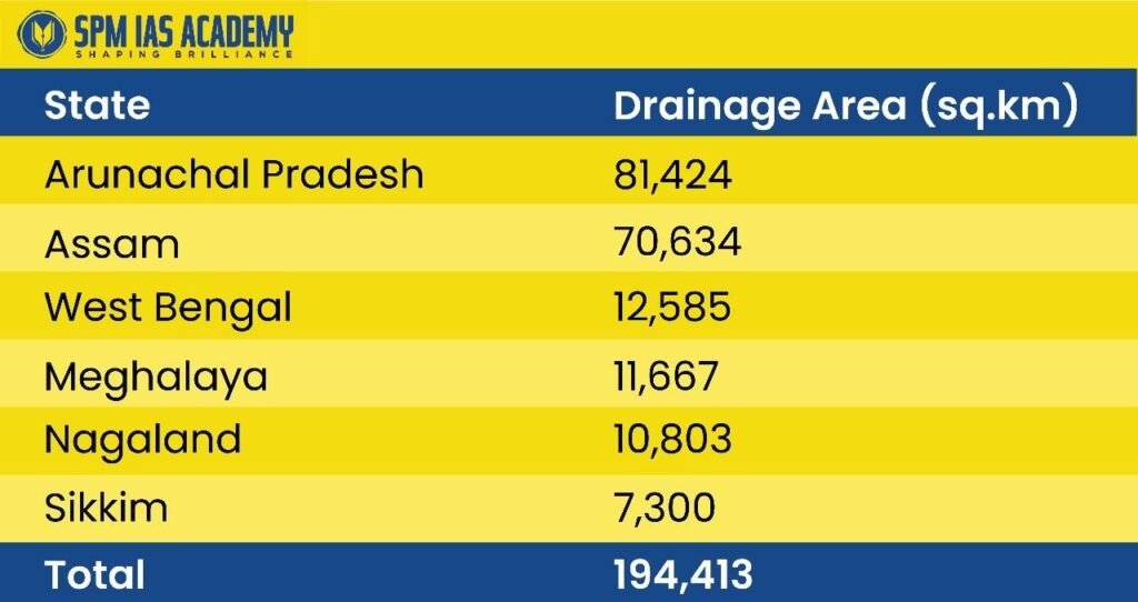
- The drainage area lying in India is 1,94,413 sq.km which is nearly 5.9% of the total geographical area of the country.
- In Assam, the total drainage area is 70,634 sq. km.
Characteristics of the North and South Bank Tributaries of Brahmaputra:
| North Bank Tributaries | South Bank Tributaries |
| Have very steep slopes and shallow braided channels for a considerable distance from the foot hills and in some cases right up to the outfall. | Have comparatively flatter grades and deep meandering channels almost from the foot hills. |
| Have boulder, pebble and coarse sandy beds and carry a heavy silt charge. | Have comparatively low silt charge. |
| Generally, have flashy floods. | |
Major Tributaries of the Brahmaputra River in Assam:
The Brahmaputra receives numerous tributaries from both its northern (right-bank) and southern (left-bank) sides. These tributaries bring immense water volume and sediments, making the Brahmaputra one of the largest alluvial plains in the world.
List of Left and Right Bank Tributaries of the Brahmaputra:
| South (Left) Bank Tributaries | North (Right) Bank Tributaries |
| Dangori | Gai |
| Dibru | Jia Dhal |
| Burhi Dihing | Subansiri |
| Disang | Ranga Nadi |
| Dikhou | Dikrong |
| Janji | Buroi |
| Teok | Barganga |
| Bhogdoi | Jia Bharali |
| Kakadonga | Gabharu |
| Dhansiri | Panch Noi |
| Daiyang | Jia Dhansiri |
| Kalong | Barnadi |
| Jamuna | Puthimari |
| Kopili | Baralia |
| Daiyang (B) or Diyung | Pagladia |
| Barapani | Kaldia |
| Kiling (Umiam) | Pahumara |
| Digaru (Umtru) | Beki-Manas-Ai |
| Kulsi | Champamati |
| Boko | Saralbhanga |
| Singra | Gadadhar |
| Dudhnoi | Gangadhar |
| Krishnai | Sonkosh |
| Jinari | |
| Jinjiram |
Hydrological and Geographical Importance:
- The Brahmaputra’s tributaries make it a braided and meandering river system, influencing the topography and floodplain of Assam.
- They bring enormous silt and sediment, which enriches the agricultural fertility of the Assam valley.
- However, they also cause seasonal floods and erosion, affecting lives and livelihoods in the region.
- These tributaries are vital for hydropower, irrigation, inland navigation, and biodiversity conservation.
Thus, the network of tributaries defines both the boon and challenges of the Brahmaputra Basin.
Conclusion:
The Brahmaputra River and its vast network of left-bank and right-bank tributaries form the hydrological backbone of Assam and the entire Northeast. These tributaries not only enrich the region through fertile alluvial deposits but also shape its climate, agriculture, biodiversity, and cultural landscape. For UPSC and APSC aspirants, understanding this river system is essential because it links multiple disciplines—physical geography, disaster management, environmental sustainability, and regional development.
Despite the challenges of floods, bank erosion, and shifting channels, the Brahmaputra Basin remains one of India’s most resource-rich and ecologically dynamic regions. Its tributaries support hydropower potential, irrigation networks, inland waterways, and diverse ecosystems that sustain millions of people. Therefore, any long-term planning—whether for climate resilience, flood control, or sustainable development—must consider the crucial role played by these tributaries.
In essence, the Brahmaputra’s tributaries are not just geographical features; they are lifelines that continue to shape the socio-economic future of Assam and Northeast India.
Sources:
FAQ:
The Brahmaputra originates from the Chemayungdung Glacier in Tibet, near the Kailash Range, at about 5300 metres above sea level.
Important left-bank (south bank) tributaries include Burhi Dihing, Disang, Dikhou, Dhansiri, Kopili, Kulsi, and Jinjiram.
The Subansiri River is the largest right-bank tributary and contributes significantly to the Brahmaputra’s water volume.
They enrich the floodplains with fertile alluvium, support agriculture, hydropower, navigation, and also shape the region’s ecology and biodiversity.
Its braided channels, heavy sediment load, steep north-bank tributaries, and intense monsoon rainfall make the river prone to annual flooding.