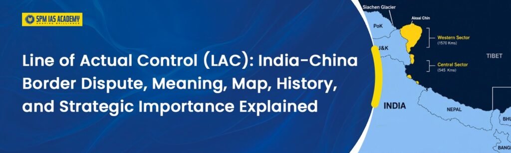
The Line of Actual Control (LAC) is the disputed de facto border between India and China. It separates Indian-controlled territory from Chinese-controlled territory across Ladakh, Himachal Pradesh, Uttarakhand, Sikkim, and Arunachal Pradesh. Moreover, the Line of Actual Control is approximately 3,488 kilometres long and extends across the western, middle, and eastern sectors. India and China have different perceptions of the border alignment. Therefore, the Line of Actual Control remains one of the most strategic geopolitical issues in Asia. Understanding the Line of Actual Control is highly important for UPSC, APSC, and other State PCS examinations.
What is LAC? – LAC full form
- The Line of Actual Control is a hypothetical or notional demarcation line between India and China. It is not a formally agreed or legally recognised international boundary.
- Moreover, the Line of Actual Control marks the areas where India and China actually exercise control on the ground.
- The Line of Actual Control emerged after the 1962 Sino-Indian War and has since functioned as the effective boundary between the two countries.
- Furthermore, Chinese Premier Zhou Enlai first used the term “Line of Actual Control” in 1959 in a letter to Indian Prime Minister Jawaharlal Nehru.
- Zhou Enlai described the Line of Actual Control as the line up to which each side exercised actual control. However, Jawaharlal Nehru rejected this interpretation because India and China disagreed on the actual positions along the border.
- Despite initial disagreements, India and China later formally recognised the term through diplomatic agreements.
- In 1993, both countries signed the Agreement on the Maintenance of Peace and Tranquility along the Line of Actual Control. However, they still did not officially demarcate the border.
- Moreover, the 1996 India-China agreement clearly stated that neither side should cross the Line of Actual Control or engage in activities that could increase tensions.
- Due to differing border perceptions and the absence of a mutually accepted map, the Line of Actual Control remains one of the most sensitive geopolitical issues in Asia.
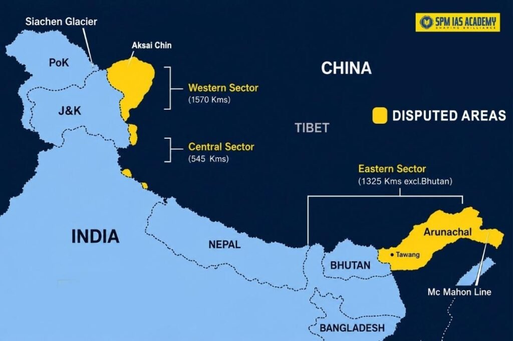
Line of Actual Control Map: Three Sectors Explained
The Line of Actual Control is divided into three main geographic sectors. Each sector has its own strategic importance and disputed areas. Here is a clear breakdown of the Line of Actual Control map:
Western Sector – Ladakh
The western sector of the Line of Actual Control lies between Ladakh (India) and the Tibet and Xinjiang autonomous regions of China. Key points about the western sector:
- This sector is the most contentious and strategically sensitive.
- India claims the entire Aksai Chin region, which China currently occupies.
- The 2020 Galwan Valley clash between Indian and Chinese troops occurred in this sector.
- Key friction points include Depsang, Galwan, Hot Springs, and Demchok.
Middle Sector – Uttarakhand and Himachal Pradesh
The middle sector of the Line of Actual Control runs between Uttarakhand and Himachal Pradesh on the Indian side and Tibet on the Chinese side. Key facts:
- This sector is relatively less disputed compared to the other two sectors.
- It covers areas like Spiti Valley, Shipki La, and Niti Pass.
- Territorial differences here are smaller in area compared to the western sector.
Eastern Sector – Arunachal Pradesh and Sikkim
The eastern sector of the Line of Actual Control lies between Arunachal Pradesh and Sikkim on the Indian side and Tibet on the Chinese side. Key facts:
- This sector broadly follows the McMahon Line, drawn during the 1914 Shimla Convention.
- China claims the entire Arunachal Pradesh, calling it “Zangnan” or South Tibet.
- India firmly rejects this claim and considers Arunachal Pradesh an integral part of India.
- Tawang in Arunachal Pradesh is a key disputed area in this sector.
What Is the History of the Line of Actual Control?
The history of the Line of Actual Control is closely connected to the India-China border dispute and the evolution of India-China relations. Moreover, these events are highly important for UPSC, APSC, and other State PCS examinations.
- 1959: Chinese Premier Zhou Enlai first used the term “Line of Actual Control” in a letter addressed to Indian Prime Minister Jawaharlal Nehru.
- 1962: The Sino-Indian War ended after China declared a unilateral ceasefire. Subsequently, the Line of Actual Control emerged as the effective de facto boundary between India and China.
- 1993: India and China signed the Agreement on the Maintenance of Peace and Tranquility along the Line of Actual Control to reduce military tensions and maintain stability along the border.
- 1996: Both countries signed another agreement that clearly stated neither side should cross the Line of Actual Control or undertake aggressive military activities near the border.
- 2013: The Daulat Beg Oldi standoff in Ladakh continued for nearly three weeks before India and China agreed to withdraw troops from the disputed area.
- 2013: India and China also signed the Border Defence Cooperation Agreement to improve communication and prevent armed confrontations along the Line of Actual Control.
- 2020: Violent clashes took place in the Galwan Valley clash in Ladakh. Soldiers from both countries lost their lives in the deadliest India-China border conflict in decades.
- October 2024: India and China reached a new patrolling agreement along the Line of Actual Control, which led to troop disengagement and reduced tensions in several friction areas.
Why Is the Line of Actual Control (LAC) Disputed?
- The Line of Actual Control is disputed because India and China have never mutually agreed on its exact alignment.
- Moreover, neither country has exchanged officially accepted maps showing a clearly demarcated international boundary.
- Therefore, India and China often maintain different perceptions about where the Line of Actual Control actually runs.
- These differing border perceptions frequently lead to Patrolling conflicts, Military standoffs, Face-offs between troops and Diplomatic tensions along the border.
- Furthermore, the terrain along the Line of Actual Control is extremely difficult and mountainous. High-altitude regions, glaciers, remote valleys, and rugged landscapes make physical demarcation very challenging.
- In addition, both India and China have important strategic and military interests in the border areas. Some of the strategic border regions are Aksai Chin, Arunachal Pradesh, Ladakh and Tawang.
- Moreover, both countries continue to strengthen military infrastructure, roads, bridges, and troop deployment near the disputed border regions.
- Due to these geographical, political, and strategic factors, India and China have not yet reached a final and legally binding agreement on the Line of Actual Control.
India’s Infrastructure Development Along the Line of Actual Control
- India has significantly increased infrastructure development along the Line of Actual Control in recent decades.
- Earlier, India avoided constructing roads and military infrastructure near the border due to security concerns. Policymakers feared that better roads could help enemy forces advance quickly during conflicts.
- However, India changed this strategy after China rapidly expanded roads, railways, airstrips, and military infrastructure on its side of the border.
- Today, India is actively building roads, tunnels, bridges, airstrips, and strategic military infrastructure near the Line of Actual Control.
- Atal Tunnel in Himachal Pradesh now provides all-weather connectivity to Ladakh and improves military movement in border areas.
- Moreover, the Darbuk-Shyok-Daulat Beg Oldi (DSDBO) Road in Ladakh has become one of India’s most important strategic roads near the Line of Actual Control.
- India has also developed advanced landing grounds and airstrips in Arunachal Pradesh and Ladakh to ensure faster troop deployment and emergency operations.
- Furthermore, the government is planning railway connectivity toward border regions near the Line of Actual Control, although railway infrastructure still lags behind roads and air connectivity.
- The Border Roads Organisation (BRO) plays a major role in constructing and maintaining roads, tunnels, and bridges near the border.
- In recent years, the Indian government has increased funding, simplified administrative procedures, and accelerated project approvals for faster infrastructure development.
- Due to these developments, India has significantly improved military logistics, strategic preparedness, border connectivity, and defence capabilities along the Line of Actual Control.
What is the difference between LAC and LOC?
- The Line of Actual Control is the de facto boundary between India and China, whereas the Line of Control is the de facto military boundary between India and Pakistan in Jammu and Kashmir.
- Moreover, the Line of Actual Control separates Indian-controlled territory from Chinese-controlled territory, while the Line of Control separates Indian-administered and Pakistan-administered areas of Jammu and Kashmir.
- The Line of Actual Control emerged after the 1962 Sino-Indian War. In contrast, the Line of Control came into existence after the 1971 India-Pakistan War and the 1972 Shimla Agreement.
- Furthermore, India and China have not mutually agreed upon the exact alignment of the Line of Actual Control. However, India and Pakistan officially recognise the Line of Control as a military control line.
- The Line of Actual Control runs across Ladakh, Himachal Pradesh, Uttarakhand, Sikkim, and Arunachal Pradesh. On the other hand, the Line of Control lies only in Jammu and Kashmir.
- Moreover, the Line of Actual Control remains largely undemarcated on the ground. In contrast, the Line of Control is clearly marked with fencing, military posts, and surveillance systems in many areas.
- Due to these differences, the Line of Actual Control and the Line of Control hold different strategic, political, and military significance in India’s national security policy.
What Is the Galwan Valley Clash?
In June 2020, violent clashes broke out between Indian and Chinese troops in the Galwan Valley in the western sector. This was the most serious confrontation along the Line of Actual Control in decades. Indian soldiers showed great bravery and China suffered losses too. The clash led to diplomatic tensions and both countries pulled back troops from certain friction points.
After several rounds of military and diplomatic talks, India and China agreed on gradual disengagement along the Line of Actual Control. In October 2024, both sides reached a new patrolling agreement. This marked a significant step toward reducing tensions along the Line of Actual Control.
Regular reading of current affairs helps aspirants understand India-China relations and important geopolitical developments more effectively.
India China border dispute explained
- The India-China border dispute is a long-standing territorial conflict between India and China over the alignment of the Line of Actual Control.
- Moreover, both countries claim certain border regions differently, which creates tensions and military standoffs along the Himalayan frontier.
- The dispute mainly involves three sectors:
- Western Sector – Ladakh and Aksai Chin
- Middle Sector – Himachal Pradesh and Uttarakhand
- Eastern Sector – Arunachal Pradesh and Sikkim
- In the western sector, India claims Aksai Chin as part of Ladakh, while China currently controls the area.
- Furthermore, in the eastern sector, China claims Arunachal Pradesh as “South Tibet,” whereas India considers it an integral part of the country.
- The border dispute became more serious after the 1962 Sino-Indian War, which led to the emergence of the Line of Actual Control as the de facto boundary between the two nations.
- Moreover, India and China have never agreed on a mutually accepted border map. Therefore, both countries often have different perceptions of the Line of Actual Control.
- This difference in perception leads to:
- Military standoffs
- Patrol clashes
- Diplomatic tensions
- Infrastructure competition near the border
- Furthermore, major incidents such as the 2020 Galwan Valley clash increased tensions between the two countries.
- In recent years, both India and China have strengthened military infrastructure, roads, bridges, and troop deployment near the disputed border regions.
- Despite tensions, both countries continue diplomatic and military talks to maintain peace and stability along the Line of Actual Control.
Therefore, the India-China border dispute remains one of the most important geopolitical and strategic issues in Asia and is highly important for UPSC, APSC, and other State PCS examinations.
What is Aksai Chin?
- Aksai Chin is a high-altitude cold desert region located in the western sector of the Line of Actual Control between India and China.
- India considers Aksai Chin a part of the Union Territory of Ladakh. However, China currently controls the region as part of Xinjiang and Tibet.
- Moreover, Aksai Chin became a major source of the India-China border dispute and played an important role in the 1962 Sino-Indian War.
- China built a strategic highway through Aksai Chin to connect Xinjiang and Tibet, which increased tensions with India.
- Due to its strategic location and military importance, Aksai Chin remains one of the most sensitive and disputed regions in India-China relations.
What is the McMahon Line?
- The McMahon Line is the proposed boundary between India and China in the eastern sector of the India-China border.
- Moreover, the McMahon Line was drawn during the 1914 Shimla Convention between British India and Tibet. It was named after Sir Henry McMahon, a British diplomat.
- The line mainly separates Arunachal Pradesh from Tibet and forms an important part of the eastern sector of the Line of Actual Control.
- India officially recognises the McMahon Line as the legal international boundary. However, China does not accept it and claims parts of Arunachal Pradesh as “South Tibet.”
Due to its historical, political, and strategic importance, the McMahon Line remains a major issue in the India-China border dispute and is highly important for UPSC, APSC, and other State PCS examinations.
Conclusion
In conclusion, the Line of Actual Control remains one of the most sensitive and strategically important borders in Asia. The Line of Actual Control plays a major role in the India-China border dispute, military strategy, and regional geopolitics. Moreover, issues related to Aksai Chin, the McMahon Line, Galwan Valley, and border infrastructure continue to influence India-China relations. Therefore, understanding the meaning, history, sectors, disputes, and strategic importance of the Line of Actual Control is highly important for UPSC, APSC, and other State PCS examinations.
Students preparing for civil services can explore trusted UPSC coaching in Assam for expert guidance and preparation.
Source:
Frequently Asked Questions:
The Line of Actual Control is the disputed de facto boundary between India and China. Moreover, it separates Indian-controlled territory from Chinese-controlled territory across Ladakh, Himachal Pradesh, Uttarakhand, Sikkim, and Arunachal Pradesh.
The full form of LAC is the Line of Actual Control. Furthermore, it refers to the effective military control line between India and China along the disputed border regions.
The Line of Actual Control is important because it plays a major role in India-China relations, border security, military strategy, and regional geopolitics. Therefore, it is highly important for UPSC, APSC, and other State PCS examinations.
The Line of Actual Control is disputed because India and China have never agreed on its exact alignment. Moreover, both countries maintain different perceptions of the border, which often leads to military standoffs and patrol clashes.
Major disputed areas along the Line of Actual Control include Aksai Chin, Ladakh, Tawang, Depsang, Galwan Valley, Demchok, and parts of Arunachal Pradesh. Furthermore, these regions hold major strategic and military importance.
The Line of Actual Control is the de facto boundary between India and China, whereas the Line of Control separates Indian-administered and Pakistan-administered areas of Jammu and Kashmir.
The Line of Actual Control is the present de facto boundary between India and China, while the McMahon Line is a proposed boundary drawn during the 1914 Shimla Convention in the eastern sector of the India-China border.