What Are the Seven Sister States?
The term “Seven Sisters” is used for the seven states in the northeastern part of India. These states are located close to each other and share many cultural, natural, and historical similarities. The region is bordered by Bhutan and China to the north, Myanmar to the east, and Bangladesh to the south and west.
This area is connected to the rest of India by a very narrow land strip called the Siliguri Corridor, also known as the “chicken’s neck.” At its narrowest point, it is only about 22 kilometers wide. Because of this, the region is somewhat separated from the rest of the country.
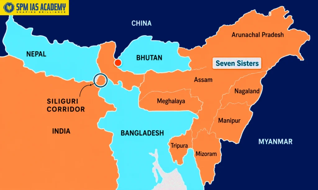
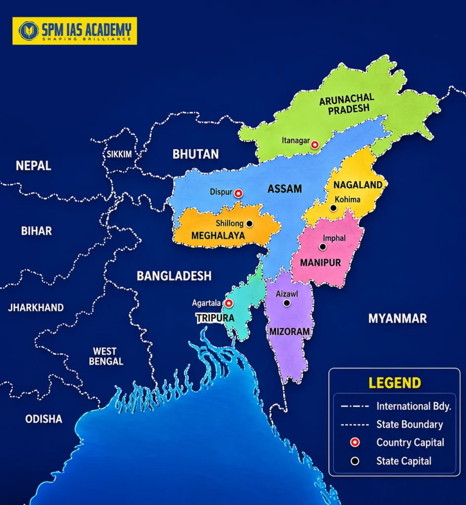
The Seven Sister States are Assam, Meghalaya, Tripura, Manipur, Mizoram, Nagaland, and Arunachal Pradesh. Along with Sikkim, which is often called the “brother” state, they form the northeastern part of India.
This region is very special because it has many different tribes, languages, and cultures. It is also rich in forests, hills, rivers, and wildlife.
Let’s talk about the history of how these states were formed. It is very interesting. Each state was created after long discussions and decisions based on the needs and identity of the local people. Some areas saw movements for separate states, while others were reorganised by the government to improve administration.
Learning about the Seven Sisters helps us understand India’s diversity and how different regions became part of the country’s federal system.
Did You Know? Northeast India is home to over 200 distinct ethnic groups speaking more than 400 languages and dialects, making it one of the most linguistically diverse regions on Earth.
Historical Background: Northeast India Under British Rule
The Colonial Administrative Structure
In the early 1800s, the British East India Company started taking control of the northeastern region of India. This area was not easy to manage because it had many different tribes, kingdoms, and local systems of rule. At first, most of this region was governed as part of the Bengal Presidency under British rule. But as the British expanded their control, they began to change and divide the region into smaller administrative units for easier management.
One important change was the creation of the Province of Assam in 1874. This became a separate administrative unit under the British.
The British also kept some areas under special control, especially the tribal hill regions. These areas were not ruled in the same way as the plains and were managed through special rules. Along with this, there were also princely states like Manipur and Tripura. These states were not directly ruled by the British, but their kings had to accept British authority in some form.
In this way, the northeastern region during British rule became a mix of directly controlled areas, special tribal regions, and semi-independent princely states..
Assam: The Colonial Heartland
Assam was the main administrative center of British rule in northeastern India. In 1874, it was separated from Bengal and made a special administrative unit called a Chief Commissioner’s Province. Later, in 1905, it was made more important and became a Lieutenant Governor’s Province. During British rule, the Assam province included a large area that later became different states like Meghalaya, Nagaland, Mizoram, and Arunachal Pradesh.
The British divided the hills and border areas of Assam into special categories called “Excluded Areas” and “Partially Excluded Areas” under the Government of India Act, 1935. These areas were not governed like normal regions and had fewer laws applied to them. They were directly controlled by the Governor in a special way. Because of this, the flat areas of the Brahmaputra Valley and the nearby hill regions developed differently, which later played an important role in the creation of new states after independence.
Manipur and Tripura: The Princely States
Manipur and Tripura occupied a different constitutional position from the rest of the region. Both were princely states—Manipur under the Maharaja and Tripura under the Manikya dynasty—that entered into subsidiary alliance arrangements with the British Crown. While they were not part of British India proper, they remained within the British sphere of influence and were administered separately.
The political geography of these states, their distinct monarchical traditions, and their ethnic compositions would play critical roles in shaping their post-independence trajectories and eventual full integration into the Indian Union.
Post-Independence Integration: 1947–1950
The Challenges of Nation-Building in the Northeast
India’s independence on 15 August 1947 presented an immediate and complex challenge in the northeast. Unlike much of peninsular India, where the integration of princely states proceeded relatively smoothly under Sardar Vallabhbhai Patel and V.P. Menon, the northeastern frontier posed unique difficulties owing to its ethnic heterogeneity, geographical isolation, and the presence of multiple insurgent movements.
At the time of independence, the region was not a clean administrative slate. The vast province of Assam included territories populated by peoples who had little linguistic or cultural affinity with the Assamese-speaking majority in the Brahmaputra Valley. The hill tribes of the Naga Hills, the Mizo Hills (then Lushai Hills), the Khasi-Jaintia Hills, and the North East Frontier Agency (NEFA) were all vastly different from each other and from the plains population.
Merger of Manipur and Tripura
Manipur was initially administered as a Part C state (a centrally administered territory) after its Maharaja, Bodhachandra Singh, signed the Instrument of Accession on 11 August 1947 and the Merger Agreement in 1949. The merger was controversial — it followed a period of political uncertainty and the controversial establishment of a Constituent Assembly in Manipur that had drafted a democratic constitution. The state was given full statehood only in 1972.
Tripura similarly acceded to India and signed the Merger Agreement in 1949. It was governed as a Part C state and later as a Union Territory before attaining full statehood in 1972. The demographic transformation of Tripura through large-scale migration from East Pakistan (later Bangladesh) significantly altered its ethnic composition and created tensions that persist to this day.
The Constitution and the Northeast (1950)
The Constitution of India, which came into force on 26 January 1950, categorized the northeastern territories across its tripartite classification of states. Assam was a Part A state (a former British province with full constitutional governance), while Manipur and Tripura were Part C states (centrally administered). The NEFA and tribal areas remained under special administrative arrangements governed by the Sixth Schedule of the Constitution, which provided for autonomous district councils in tribal areas.
Constitutional Insight: The Sixth Schedule of the Indian Constitution, drafted primarily by Dr. B.R. Ambedkar with significant input from Gopinath Bardoloi, created a unique system of autonomous district councils for tribal areas in Assam, Meghalaya, Tripura, and Mizoram—a landmark instrument of federal accommodation.
The States Reorganization Act of 1956 and the Northeast
What is The States Reorganization Commission (SRC) ?
The States Reorganization Commission, constituted in December 1953 under Justice Fazl Ali (with Hridaynath Kunzru and K.M. Panikkar as members), submitted its report in 1955. The SRC’s primary mandate was to reorganize the Indian states on linguistic lines, following the successful creation of Andhra Pradesh in 1953 on the demand for a Telugu-speaking state.
However, the SRC’s recommendations for the northeast were limited in scope. The Commission recognised the exceptional complexity of the region and was cautious about recommending wholesale reorganisation. The States Reorganisation Act of 1956 did not fundamentally alter the map of the northeast — Assam retained its vast territorial extent, and the tribal hill areas continued under their existing administrative arrangements.
Limitations of the 1956 Reorganization in the Northeast
The reluctance to reorganize the northeast in 1956 stemmed from several factors. First, the linguistic principle that guided reorganization in peninsular India was difficult to apply in a region where hundreds of languages and dialects were spoken across tiny communities. Second, the strategic sensitivity of the region — bordering China, Myanmar, and what was then East Pakistan — made the central government wary of creating administrative instability. Third, the ongoing Naga insurgency, which had begun in the early 1950s, made political consolidation a priority over territorial reorganization.
The decision to defer reorganization created a pressure cooker of ethnic and political aspirations that would explode in subsequent decades, making the 1960s–1980s the primary period of state creation in the northeast.
Creation of the Seven Sister States: Detailed History
1. Assam: The Parent State
Assam is the oldest and historically the most significant political unit in the northeast. It served as the administrative parent from which all other Northeastern states were carved. The Assamese identity is rooted in the Ahom Kingdom, which ruled the Brahmaputra Valley for nearly six centuries from 1228 to 1826, before the British annexed it following the First Anglo-Burmese War.
Post-independence, Assam struggled to accommodate the aspirations of its numerous ethnic communities within a single political framework. The Hills Districts—Khasi-Jaintia Hills, Garo Hills, Mikir Hills, North Cachar Hills, Naga Hills, and Lushai Hills—all harbored distinct identities that chafed under Assamese administrative dominance. The imposition of Assamese as the sole official language in 1960 through the Assam Official Language Act inflamed sentiments across the hill regions and contributed directly to demands for separate statehood.
Today, Assam remains the largest state in the northeast and serves as the commercial and transportation hub of the region. Its capital, Dispur (part of the Guwahati metropolitan area), is the economic capital of the entire northeast.
2. Nagaland: The First New State (1963)
The Nagas traditionally lived in independent tribal communities in the hilly regions between Assam and Myanmar. During British rule, the Naga Hills were gradually brought under colonial administration and became a district of Assam in 1881. British policies kept the region relatively isolated, helping preserve Naga customs, traditions, and tribal identity. In the early twentieth century, Naga political consciousness began to emerge.
Important developments included:
- Formation of the Naga Club in 1918
- Submission of a memorandum to the Simon Commission in 1929 demanding separate treatment for the Nagas
- Formation of the Naga National Council (NNC) in 1946
- Leadership of Angami Zapu Phizo in the Naga nationalist movement
- Declaration of Naga independence on 14 August 1947, one day before India’s independence
These developments marked the beginning of organized Naga political aspirations and demands for self-determination.
Rise of Insurgency and Demand for Statehood
After independence, the Naga territory remained part of Assam, but tensions between the NNC and the Government of India gradually intensified. In 1951, the NNC conducted a plebiscite claiming overwhelming support for Naga independence, though the Indian government did not recognize it. By 1956, the movement transformed into an armed insurgency with the creation of the underground Federal Government of Nagaland (FGN).
To address the growing unrest:
- In 1957, the Naga Hills district of Assam and the Tuensang Frontier Division were merged
- The new administrative unit was called the Naga Hills-Tuensang Area (NHTA)
- The area was placed under the direct administration of the Government of India
At the same time, moderate Naga leaders formed the Naga People’s Convention (NPC) in 1957 to seek a peaceful settlement within the Indian Union. Negotiations between the NPC and Prime Minister Jawaharlal Nehru resulted in the historic 16-Point Agreement signed on 26 July 1960.
The agreement provided for:
- Creation of a separate state called Nagaland
- Protection of Naga customs and traditions
- Special safeguards over land and resources
- Greater administrative and political autonomy
Formation of Nagaland and Its Significance
In February 1961, the Naga Hills-Tuensang Area was officially renamed Nagaland. Parliament later passed the State of Nagaland Act, 1962, and after receiving Presidential assent on 4 September 1962, Nagaland formally became the 16th state of India on 1 December 1963 with Kohima as its capital.
At the time of statehood, Nagaland had three districts:
- Kohima
- Mokokchung
- Tuensang
The formation of Nagaland was historically significant because the following:
- It was the first northeastern state created after the 1956 reorganization period
- It was the first Indian state formed mainly in response to insurgency and ethnic demands
- It established a model of political negotiation within Indian federalism
- It led to the inclusion of Article 371A, which protects Naga customary laws, traditions, and land rights
Although insurgency continued in later decades through groups such as the NSCN, the creation of Nagaland remains an important example of India’s effort to balance national integration with regional identity and autonomy.
3. Meghalaya: Abode of the Clouds (1972)
Historical Background of the Meghalaya Movement
Before the formation of Meghalaya, the Khasi, Jaintia, and Garo Hills were part of Assam. These tribal communities had distinct cultural and social identities, especially the matrilineal traditions of the Khasi and Jaintia societies. After independence, many hill leaders feared that their identity and political interests would be overshadowed within Assam. Important developments included:
- Formation of the All Party Hill Leaders’ Conference (APHLC) in 1960
- Demand for a separate hill state for the Khasi, Jaintia, and Garo people
- Peaceful democratic movements and negotiations with the Government of India
Meghalaya as an Autonomous State
The Government of India responded to the demands through constitutional measures rather than force. The 22nd Constitutional Amendment Act, 1969 created Meghalaya as an autonomous state within Assam, which came into effect on 2 April 1970. Under this arrangement:
- Meghalaya received a separate legislature
- A council of ministers was created
- Limited self-governance was granted to the hill areas
However, the demand for complete statehood continued through peaceful negotiations.
Formation of Meghalaya State
Through the North-Eastern Areas (Reorganisation) Act, 1971, Meghalaya officially became a full-fledged state on 21 January 1972. Shillong, which had served as the capital of Assam since 1874, became the capital of Meghalaya because it fell within the new state’s territory. After Meghalaya’s formation, Assam shifted its capital to Dispur in Guwahati in 1973. The creation of Meghalaya is regarded as an important example of peaceful constitutional negotiation and the recognition of tribal identity, regional autonomy, and democratic federalism in Northeast India.
4. Manipur: Full Statehood (1972)
Manipur was an independent princely state before joining India. After India’s independence, Manipur adopted a democratic constitution and elected an assembly in 1948. However, in 1949, the Maharaja of Manipur signed the merger agreement with India, after which Manipur became part of the Indian Union. Many people in Manipur considered the merger controversial, leading to feelings of political marginalization and the growth of regional discontent.
Political Developments and Rise of Insurgency
After the merger, Manipur was reduced to a Part C state and later became a Union Territory, which increased dissatisfaction among many groups. Several insurgent organizations emerged, drawing support mainly from Meitei nationalist sentiment.
Important developments included:
- Growth of political movements demanding greater autonomy
- Formation of insurgent groups such as the United National Liberation Front (UNLF) and the People’s Liberation Army (PLA)
- Demands for restoration of political rights and statehood
At the same time, ethnic divisions between the Meitei-majority valley and the Naga and Kuki-Zo inhabited hill districts continued to shape Manipur’s politics.
Formation of Manipur State
Through the North-Eastern Areas (Reorganisation) Act, 1971, Manipur was granted full statehood on 21 January 1972 with Imphal as its capital. On the same day, Tripura and Meghalaya also became full-fledged states of India. Since then, 21 January has been observed as Statehood Day in these states. Although statehood gave Manipur greater political autonomy within the Indian Union, the state continued to face ethnic tensions, insurgency, and internal political challenges that have persisted into the twenty-first century.
5. Tripura: From Princely State to Full Statehood (1972)
Tripura followed a path to statehood similar to that of Manipur. It became a full-fledged state on 21 January 1972 under the North-Eastern Areas (Reorganisation) Act, 1971. Although Tripura is one of the smallest states in Northeast India, its history is unique because of the major demographic changes that took place during the twentieth century.
At the time of India’s partition in 1947, Tripura’s population was mainly made up of indigenous tribal communities. However, large numbers of Bengali Hindu refugees migrated from East Pakistan (now Bangladesh) during the Partition and later again during the Bangladesh Liberation War of 1971. This large-scale migration significantly changed the population structure of the state.
By the 1980s, the tribal communities had become a minority in their own homeland, leading to ethnic tensions and political unrest. Several insurgent groups emerged, including:
- All Tripura Tiger Force (ATTF)
- National Liberation Front of Tripura (NLFT)
These groups demanded greater rights and protection for the tribal population. Despite these challenges, Tripura continued to develop as an important state within the Indian Union.
6. Mizoram: Born of Peace (1987)
Historical Background of Mizoram
Mizoram was originally known as the Mizo Hills district of Assam. The demand for greater autonomy grew after the devastating Mautam famine of 1959, which was caused by the mass flowering of bamboo that led to a sudden increase in rats and widespread destruction of crops. Many Mizos believed that the Indian government failed to respond adequately to the crisis, leading to widespread dissatisfaction among the people.
Rise of the Mizo National Front (MNF)
In response to growing discontent, the Mizo National Front (MNF) was formed under the leadership of Laldenga. On 28 February–1 March 1966, the MNF launched an armed uprising demanding independence for Mizoram. The insurgency continued for nearly two decades and became one of the longest and most intense insurgencies in Indian history.
Important developments included:
- The Mizo Hills area was separated from Assam
- Mizoram became a Union Territory in 1972
- Peace negotiations continued between the Government of India and the MNF
Formation of Mizoram State
A major breakthrough came with the signing of the Mizo Peace Accord in 1986 between the Government of India and the MNF under Prime Minister Rajiv Gandhi. Under the agreement:
- The MNF agreed to give up armed struggle
- The Government of India granted full statehood to Mizoram
- Peaceful democratic governance was restored
As a result, Mizoram became a full-fledged state on 20 February 1987 with Aizawl as its capital. Many regard the Mizoram Peace Accord as one of India’s most successful examples of conflict resolution and political accommodation.
7. Arunachal Pradesh: The Land of the Dawn-Lit Mountains (1987)
Historical Background of Arunachal Pradesh
Arunachal Pradesh has a unique history among the Seven Sister States because of its strategic location along the borders of China and Myanmar. During the colonial and early post-independence period, the government administered the region as the North East Frontier Agency (NEFA). Unlike other northeastern regions, the government placed NEFA under the Ministry of External Affairs because of its sensitive international border location and its importance in India’s foreign policy and security.
Strategic Importance and the 1962 War
Arunachal Pradesh became highly significant after the Indo-China War of 1962, when Chinese forces briefly occupied parts of NEFA before later withdrawing. The war highlighted the strategic importance of the frontier region and increased the Government of India’s focus on its administration and development.
Important developments included:
- NEFA continued under special central administration
- The region was renamed Arunachal Pradesh in 1972
- Arunachal Pradesh became a Union Territory in 1972
China continues to claim a large part of Arunachal Pradesh as “South Tibet,” making the region strategically important even today.
Formation of Arunachal Pradesh State
The demand for greater political representation and administrative autonomy gradually led to full statehood. Parliament passed the Statehood Act in 1986, and Arunachal Pradesh officially became a full-fledged state on 20 February 1987, the same day Mizoram attained statehood. The government also declared Itanagar as the state capital. The creation of Arunachal Pradesh strengthened India’s administrative and political presence in the frontier region and remains important in the context of India-China relations.
Quick Reference: The Seven Sister States at a Glance
| State | Year Created | Capital | Key Ethnic Groups | Basis of Formation |
| Assam | Pre-independence (reorganised 1950) | Dispur | Assamese, Bodo, Bengali | Colonial province; retained post-independence |
| Manipur | 1972 (Full statehood) | Imphal | Meitei, Naga, Kuki-Zo | Merger with India 1949; statehood 1972 |
| Meghalaya | 1972 | Shillong | Khasi, Garo, Jaintia | Carved from Assam; tribal autonomy demand |
| Tripura | 1972 (Full statehood) | Agartala | Bengali, Tripuri, Reang | Princely state; statehood 1972 |
| Mizoram | 1987 | Aizawl | Mizo (Lushai) | Peace accord 1986; statehood 1987 |
| Nagaland | 1963 | Kohima | Naga tribes (16+) | First new state from Assam; Naga insurgency |
| Arunachal Pradesh | 1987 | Itanagar | Adi, Nyishi, Monpa, Apatani | NEFA; strategic border area |
Key Legislation Governing States’ Reorganization in the Northeast
A series of constitutional amendments and parliamentary acts led to the creation of the Seven Sister States. Understanding these legislative instruments is essential for students of Indian constitutional law and political science.
- State of Nagaland Act, 1962 — Created Nagaland as the 16th state of India, effective 1 December 1963.
- 22nd Constitutional Amendment Act, 1969—Established Meghalaya as an autonomous state within Assam as an intermediate step toward full statehood.
- North-Eastern Areas (Reorganization) Act, 1971 — The most consequential legislation, which simultaneously created the full states of Meghalaya, Manipur, and Tripura, and converted Mizoram and Arunachal Pradesh into Union Territories.
- State of Mizoram Act, 1986 — Converted Mizoram from a Union Territory to a full state, effective 20 February 1987.
- State of Arunachal Pradesh Act, 1986 — Elevated Arunachal Pradesh to full statehood on 20 February 1987.
Factors Driving States’ Reorganization in the Northeast
Ethnic and Tribal Identity
Unlike the linguistic principle that governed reorganisation in peninsular India, ethnic and tribal identities predominantly drove the reorganization of the Northeast. Each state corresponds broadly (though imperfectly) to the homeland of one or more ethnic communities: Nagas in Nagaland, Mizos in Mizoram, Khasi-Jaintia-Garo peoples in Meghalaya, Meitei in Manipur’s valleys, and so on.
Insurgency and Political Negotiation
Several states owe their creation directly to armed insurgency. Nagaland (1963) and Mizoram (1987) are the clearest examples. In both cases, decades of armed conflict preceded political resolution through statehood. This established a troubling but pragmatic pattern in Indian federalism: armed struggle as a catalyst for political accommodation.
Colonial Administrative Legacy
The British distinction between plains and hills, between ‘excluded’ and ‘included’ areas, created the structural conditions for post-independence fragmentation. The hill peoples had been administered separately, had developed distinct political consciousness, and were resistant to absorption into the Assamese administrative framework.
The Language Policy Controversy
The Assam Official Language Act of 1960, which designated Assamese as the sole official language, was a significant catalyst for separatist demands from the hill regions, where Assamese was neither spoken nor accepted as a language of identity. This policy error accelerated the demands that eventually resulted in the creation of Meghalaya and fuelled unrest in other hill districts.
The Northeast Today: Ongoing Challenges and Opportunities
Persisting Ethnic Conflicts
Despite the creation of separate states, ethnic conflicts within individual states remain a defining feature of the region’s political landscape. Manipur’s valley-hills divide, Assam’s Bodo-Bengali tensions, Nagaland’s inter-tribal rivalries, and Arunachal Pradesh’s demographic pressures from illegal immigration all testify to the limits of state reorganisation as a solution to ethnic complexity.
The Act East Policy and Regional Development
India’s Act East Policy (formerly Look East Policy) positions the northeast as the gateway to Southeast Asia. The region’s borders with Myanmar, Bangladesh, Bhutan, and China give it a geopolitical significance that is increasingly recognised in India’s foreign policy. Infrastructure development — roads, railways, airports, and waterways — has accelerated in the region since the 2010s, gradually reducing the isolation that has historically retarded development.
Insurgency, Peace Processes, and the Path Forward
Multiple insurgent groups continue to operate in the region, including various Naga factions (with the Framework Agreement signed between the Government of India and the NHLC’s Isak-Muivah faction in 2015 still awaiting final resolution), Manipur-based groups, and Assam’s ULFA. The northeast’s peace processes represent some of the most complex and long-running negotiations in the world. Sustained development, genuine political inclusion, and respect for ethnic identities are prerequisites for lasting peace.
Looking Ahead: The Northeast is no longer India’s forgotten periphery. With the completion of major infrastructure projects, the expansion of air connectivity, and the growing recognition of the region’s cultural richness and strategic importance, the Seven Sister States are increasingly integrated into India’s national mainstream — while proudly retaining their distinct identities.
Conclusion
The creation of the Seven Sister States of Northeast India represents one of the most complex experiments in democratic federalism in the world. Unlike the relatively clean linguistic reorganization of peninsular India, the northeast’s state-making was driven by tribal identity, colonial legacy, armed insurgency, and the pragmatic imperatives of a multi-ethnic democracy seeking to hold together an extraordinarily diverse population.
Each state embodies a distinct historical narrative: Nagaland’s decades-long armed struggle, Meghalaya’s cultural distinctiveness, Manipur’s contested merger, Tripura’s demographic upheaval, Mizoram’s successful peace accord, Arunachal Pradesh’s strategic frontier role, and Assam’s continuing centrality as the region’s economic and administrative heart. Together, these seven states — with Sikkim as their ‘brother’ — form a region that is both a challenge and an opportunity for Indian democracy.
As the northeast moves into a new era of connectivity and development, understanding the history of states reorganisation in the region is not merely an academic exercise. It is essential context for grappling with the ongoing negotiations over Naga political aspirations, Manipur’s internal conflicts, Assam’s citizenship debates, and the broader question of how a diverse nation-state accommodates the aspirations of its most ethnically complex frontier.
The Seven Sisters remain united in their diversity — a microcosm of the Indian democratic experiment itself.
Key References and Further Reading
- Baruah, Sanjib. India Against Itself: Assam and the Politics of Nationality. University of Pennsylvania Press, 1999.
- Bhaumik, Subir. Troubled Periphery: Crisis of India’s North East. SAGE Publications, 2009.
- Chaube, S.K. Hill Politics in Northeast India. Orient Longman, 1973.
- Dasgupta, Jyotirindra. Language Conflict and National Development. University of California Press, 1970.
- Hazarika, Sanjoy. Strangers of the Mist: Tales of War and Peace from India’s Northeast. Viking, 1994.
- North-Eastern Areas (Reorganisation) Act, 1971. Government of India.
- State of Nagaland Act, 1962. Government of India.
- The Constitution of India — Sixth Schedule. Ministry of Law and Justice, Government of India.

Behind every article at SPM IAS Academy is a team of skilled content writers and subject experts committed to making preparation easier for aspirants. From answering common doubts to breaking down complex issues and current affairs, we create content that is accurate, easy to understand, and directly useful for UPSC, APSC, and other competitive exams.