The Brahmaputra River, one of the world’s most magnificent and complex waterways, stands as a testament to the dynamic forces of nature that shape our planet. This blog delves into the intricate morphological characteristics of the Brahmaputra, offering a detailed look at its course, channel patterns, sediment load, and the myriad factors that contribute to its ever-evolving landscape.
A River of Epic Proportions
The Brahmaputra is not merely a river; it is a lifeline that spans three countries, nurtures diverse ecosystems, and supports millions of lives. With a journey of approximately 2,880 kilometers, this mighty river showcases a range of geological and hydrological features that make it a subject of fascination for researchers, environmentalists, and policymakers alike.
Key Facts:
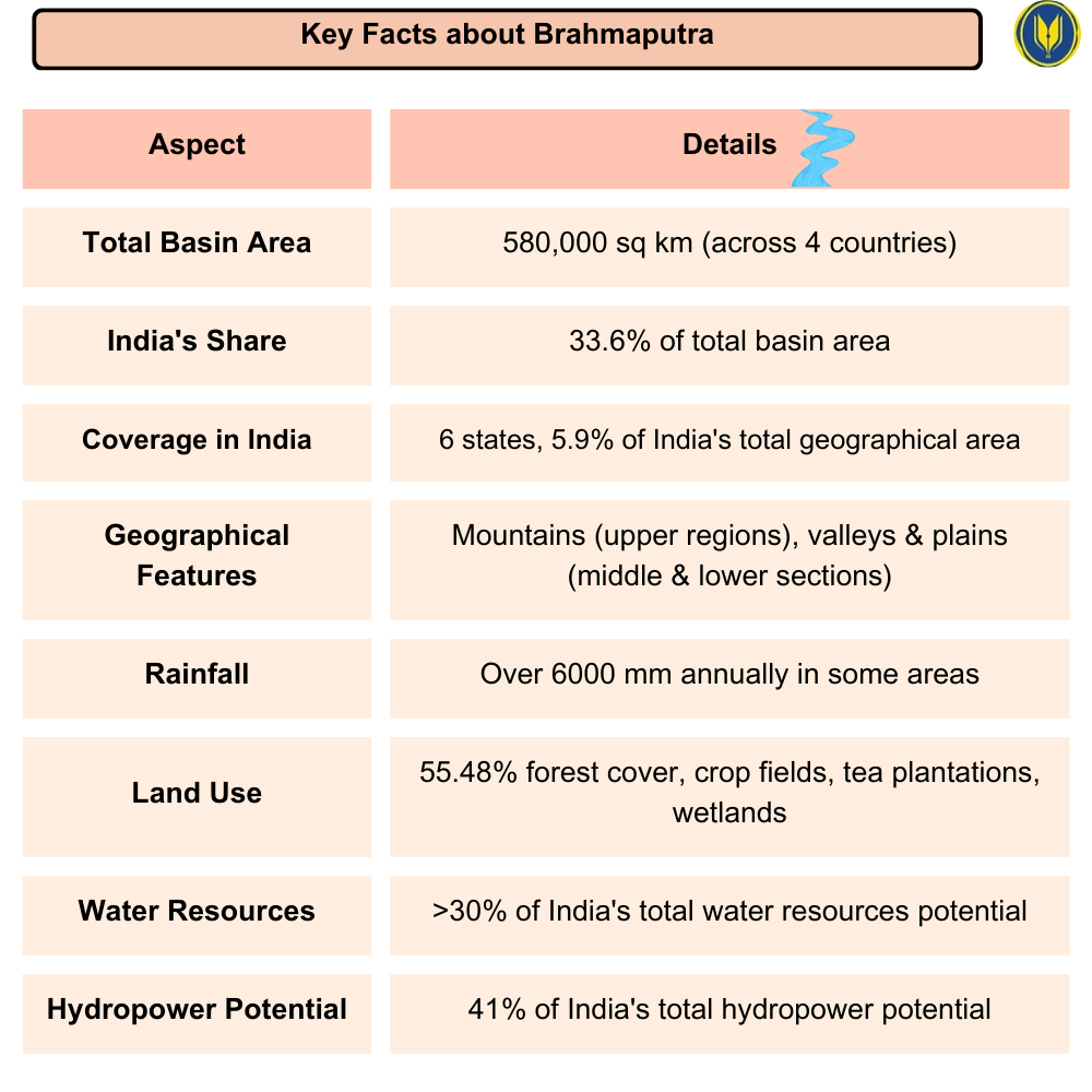
- The Brahmaputra Basin covers 580,000 sq km across four countries, with India containing 33.6% of the total area.
- In India, the basin spans six states and covers 5.9% of the country’s total geographical area.
- The basin’s geography varies from mountainous upper regions to wide valleys and plains in the middle and lower sections.
- The basin experiences heavy rainfall, with some areas receiving over 6000 mm annually.
- Forests cover 55.48% of the basin area, alongside crop fields, tea plantations, and wetlands.
- The Brahmaputra and its tributaries carry more than 30% of India’s total water resources potential.
- The region possesses 41% of India’s total hydropower potential.
The River’s Journey: From Tibet to the Bay of Bengal
Upper Course: The Tibetan Plateau
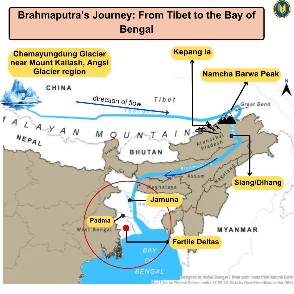
The story of the Brahmaputra begins in the remote reaches of Tibet, east of the sacred Mansarovar Lake. Here, known as the Tsangpo, the river embarks on a 1,625-kilometer eastward journey across the Tibetan plateau. This upper course is characterized by:
- A relatively gentle slope, belying the dramatic changes to come
- Pristine, high-altitude landscapes
- Crucial ecological importance for the Tibetan plateau
Middle Course: The Indian Odyssey
As the river enters India through Arunachal Pradesh, it undergoes a dramatic transformation:
- A sharp southward turn at the Namcha Barwa peak, marking the beginning of its descent from the Tibetan plateau
- Entry into the state of Assam, where it gains its identity as the Brahmaputra
- Development of its characteristic braided channel pattern
Lower Course: The Bangladeshi Delta
In its final stretch, the river, now known as the Jamuna in Bangladesh:
- Merges with the Ganges to form the mighty Padma
- Creates one of the world’s largest and most fertile deltas
- Finally empties into the Bay of Bengal, completing its epic journey
Channel Patterns of the Brahmaputra
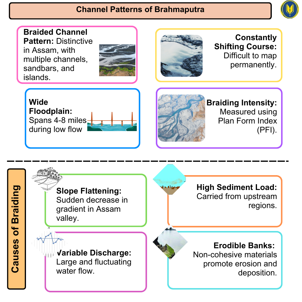
One of the most distinctive features of the Brahmaputra is its braided channel pattern, particularly evident in its course through Assam. This complex network of channels creates a river landscape that is both beautiful and challenging:
- Multiple channels separated by ephemeral sand bars and more stable islands
- A constantly shifting river course that defies attempts at permanent mapping
- A wide floodplain that can span 4-8 miles during low flow periods
The braiding intensity of the Brahmaputra is not uniform and can be quantified using indices such as the Plan Form Index (PFI). This braided nature is the result of several interacting factors:
- The sudden flattening of the river slope as it enters the Assam valley
- An exceptionally high sediment load
- Large and highly variable water discharge rates
- Non-cohesive bank materials that are easily eroded and deposited
Sediment Load and Transport
The Brahmaputra is renowned for its enormous sediment load, a key factor in shaping its morphology and ecological impact:
- An annual sediment load of approximately 1 billion tonnes
- A high proportion of sand in the sediment mix, contributing to its braiding tendency
- Significant seasonal variations in sediment transport, with peak loads during the monsoon
Historical perspective adds depth to our understanding:
- During the early Holocene (10-8 ka), sediment delivery rates reached up to 2,000 Mt/yr
- This historical variability is closely linked to changes in monsoon strength and climate conditions
Landforms Shaped by the River
The Brahmaputra’s dynamic nature results in the formation of various fluvial landforms, each with its own ecological and cultural significance:
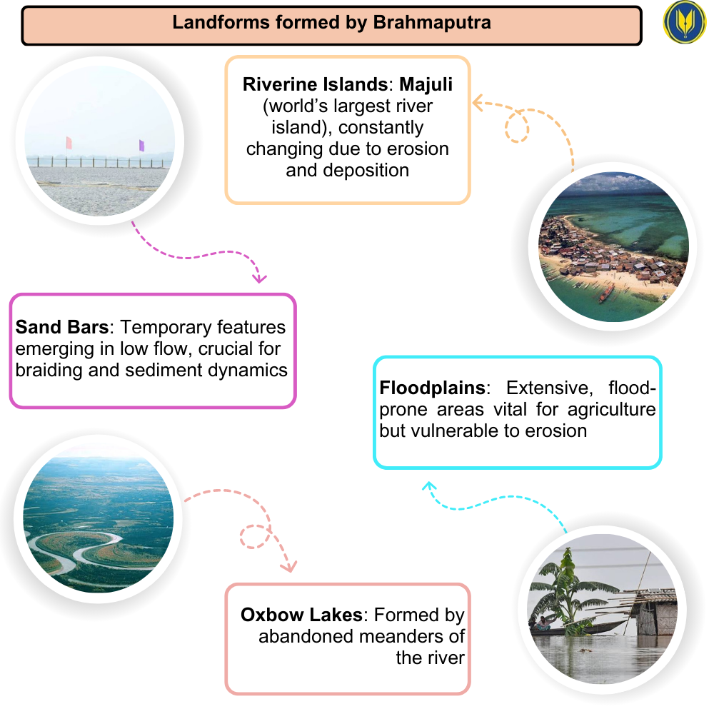
Riverine Islands
- Majuli, the world’s largest river island, stands as a prime example
- These islands are in a constant state of flux, changing size and shape due to erosion and deposition
Sand Bars
- Temporary features that emerge during low flow periods
- Play a crucial role in the river’s braiding process and sediment dynamics
Floodplains
- Extensive areas subject to annual flooding
- Vital for agriculture but also vulnerable to erosion and land loss
Oxbow Lakes
- Formed when the river changes course, leaving behind curved bodies of water
- Important aquatic ecosystems and water resources for local communities
Factors Influencing River Morphology
The Brahmaputra’s unique morphology is the result of several interacting factors:
Tectonic Activity
- The river flows through a tectonically active region
- Earthquakes can cause sudden changes in river course and sediment load
Monsoon Climate
- Seasonal variations in rainfall significantly affect river discharge and sediment transport
- Approximately 95% of the sediment load is delivered during the monsoon season (May-October)
Glacial Melt
- Contributes to river flow, especially in the upper reaches
- Climate change may alter this contribution in the future, with potential far-reaching consequences
Human Interventions
- Dam construction and river diversions can impact sediment flow and river morphology
- Sand mining affects the river’s bedload and channel stability
Morphological Changes and Challenges
The Brahmaputra’s morphology is in a constant state of flux, presenting several challenges for the regions it traverses:
Bank Erosion
- A major issue, especially in Assam
- Causes loss of agricultural land and displacement of communities
Flooding
- Annual floods affect millions of people in the river basin
- Linked to the river’s high discharge and sediment load
Channel Migration
- The river frequently shifts its course
- Complicates land use planning and infrastructure development
Sedimentation
- Aggradation of the river bed can increase flood risk
- Affects navigation and the lifespan of hydraulic structures
Looking Ahead: Future Projections and Management
Recent studies have modeled potential changes in the Brahmaputra’s morphology under future climate scenarios:
- Projections suggest possible increases in sediment load of 34-60% due to strengthened monsoon precipitation
- However, proposed dams and diversions could potentially reduce sediment load by 15-80%
These conflicting scenarios highlight the need for careful management of the Brahmaputra River system. Sustainable management strategies should consider:
- Integrated basin management approaches
- Balancing development needs with ecological preservation
- Implementing nature-based solutions for flood and erosion control
- Continuous monitoring and research on river dynamics
Conclusion
The morphology of the Brahmaputra River is a complex and fascinating subject, shaped by a myriad of natural processes and increasingly influenced by human activities. Its braided channels, enormous sediment load, and dynamic nature make it one of the most challenging rivers to manage and study. As climate change and development pressures continue to impact the river system, understanding and adapting to its morphological characteristics will be crucial for the millions of people who depend on this mighty river.
MCQ:
Q. Which of the following statements correctly describes the geography of the Brahmaputra Basin?
A) The Brahmaputra Basin covers 580,000 sq km, with India accounting for 45% of the total area.
B) The Brahmaputra Basin experiences heavy rainfall, with some areas receiving over 6000 mm annually.
C) The basin’s geography consists only of mountainous upper regions, with no plains or valleys.
D) The river, known as the Tsangpo in India, enters the country through Arunachal Pradesh and flows northward.
Correct Answer: B) The Brahmaputra Basin experiences heavy rainfall, with some areas receiving over 6000 mm annually.
Explanation:
Option B is correct as the Brahmaputra Basin, particularly in its middle and lower courses, experiences heavy rainfall, with some regions receiving over 6000 mm annually.
- Option A is incorrect because India contains 33.6% of the Brahmaputra Basin area, not 45%.
- Option C is incorrect as the basin’s geography varies from mountainous upper regions to wide valleys and plains.
- Option D is incorrect because the river enters India through Arunachal Pradesh and flows southward, not northward.
Mains Question:
Q. Discuss the geographical significance of the Brahmaputra Basin in India, highlighting its hydrological, ecological, and economic importance. How does its diverse geography influence the socio-economic development of the region?