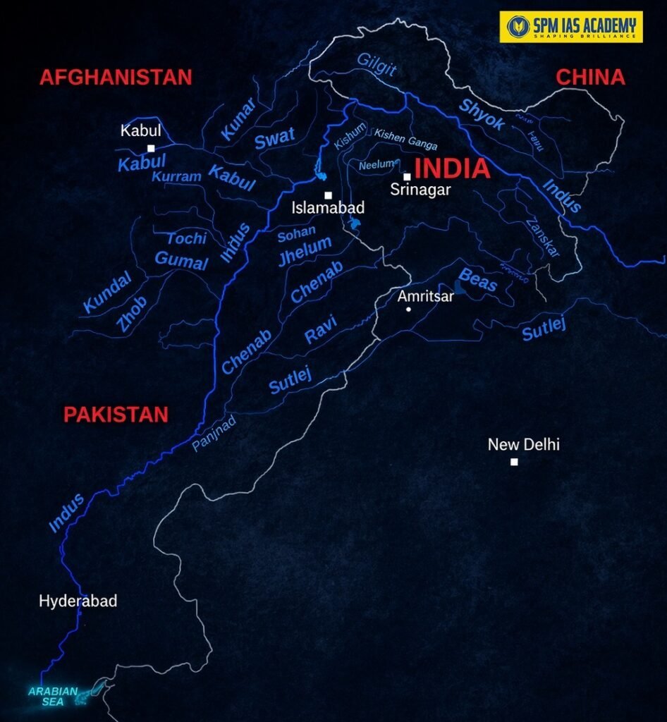
The Indus River system is one of the largest river systems in the world. The river originates from the Bokhar Chu glacier near the Mount Kailash in Tibet. The river flows through India and Pakistan before draining into the Arabian Sea near Karachi. The total length of the Indus is about 3,180 km. However, only about 800.75 km of the river flows through India.
Quick Facts – Indus River Drainage System:
| Parameter | Details |
| Total Length | 3,180 km |
| Length in India | 800.75 km (Ladakh only) |
| Origin | Bokhar Chu glacier, Kailash Range, Tibet (Senge Khamban / Lion’s Mouth spring) |
| Elevation at source | Approx. 5,182 m |
| Drainage basin area | 11,65,500 sq. km (one of largest in world) |
| India’s share of basin | 3,21,289 sq. km |
| Ends at | Arabian Sea near Karachi, Pakistan (Indus Delta) |
| Countries covered | China (Tibet), India, Pakistan |
| Annual flow | ~175 km³/year — among top 50 rivers globally |
| Major tributaries | Jhelum, Chenab, Ravi, Beas, Sutlej (left bank); Shyok, Gilgit, Kabul (right bank) |
| Drainage type | Antecedent / Consequent — pre-dates Himalayas |
| Historical name | Sindhu (Sanskrit); Sinthos (Greek); Singi Khamban (Tibetan) |
| Indus Valley Civilisation | ~2500 BCE — Harappa, Mohenjo-daro, Lothal, Dholavira |
About Indus River basin
- The Indus River basin extends across China (Tibet), India, Afghanistan, and Pakistan, and it drains an area of about 11,65,500 sq. km.
- In India, the basin covers the Union Territory of Ladakh, Jammu & Kashmir, Chandigarh and the states of Himachal Pradesh, Punjab, parts of Rajasthan and Haryana.
- Altogether, it occupies around 3,21,289 sq. km in India, which is nearly 9.8% of the country’s total geographical area.
- Geographically, the basin lies between 72°28′ to 79°39′ East longitudes and 29°8′ to 36°59′ North latitudes.
- In terms of physical boundaries, the basin is surrounded by major mountain ranges and natural features. Specifically, the Himalayas bound it on the east, while the Karakoram and Haramosh ranges form its northern boundary.
- Similarly, the Sulaiman and Kirthar ranges lie on the west, and finally, the Arabian Sea forms its southern boundary.
What is the source and mouth of the Indus River system?
Origin or source of Indus River
The Indus River rises from the Bokhar Chu (glacier) on the northern slopes of the Kailash mountain range in Tibet, at an elevation of about 5,182 metres. The traditional source is called Senge Khamban or Senggê Kanbab, meaning ‘Lion’s Mouth’ which is a perennial spring near sacred Mount Kailash. It is also known as Singi Khamban in Tibetan.
Indus River drainage system – How the Indus Flows
- Tibet: Flows North-West through Tibet between Karakoram and Ladakh ranges. In Tibet, the Indus River is known as Singi Khamban.
- Enters India: The river enters India at Demchok in Ladakh. This is where India’s share of the Indus begins.
- Ladakh: In Ladakh, it flows north-west between the Ladakh Range and Zaskar Range. It passes through Leh and then receives the Zaskar River below Leh.
- Skardu: River receives the Shyok tributary. Then Shigar River joins. The river then continues to flow in the North-West direction and enters Pakistan (Gilgit-Baltistan).
- Pakistan: After Gilgit, it takes a southward bend and cuts through Himalayas at Attock. It receives Kabul River on the right bank at Attock.
- Punjab plains (Pakistan): All 5 eastern tributaries (Jhelum, Chenab, Ravi, Beas, Sutlej) join via the Panjnad (Panchnad) just above Mithankot.
- Sindh, Pakistan: River collects sediments and forms a large delta before emptying into the Arabian Sea.
Major Tributaries of the Indus River System
The Indus has two types of tributaries – left bank (eastern, the famous Punjab rivers) and right bank (western, Himalayan and Afghan rivers). The table below gives a complete overview:
| River | Bank | Length | Origin | Key States/Region | IWT Allocation | Key Facts |
| Jhelum | Left | 724 km | Verinag spring, Pir Panjal, SE Kashmir | J&K, Pakistan | Pakistan | Flows through Srinagar, Wular Lake. Joins Chenab in Pakistan. |
| Chenab | Left | 960 km | Bara Lacha Pass, Lahul-Spiti (Chandra + Bhaga at Tandi, HP) | HP, J&K, Pakistan | Pakistan | Largest tributary. Also called Chandrabhaga. World’s highest railway bridge. |
| Ravi | Left | 720 km | W of Rohtang Pass, Kullu Hills, HP | HP, Punjab (Pak) | India | Flows through Chamba Valley. Thein / Ranjit Sagar Dam. |
| Beas | Left | 470 km | Rohtang Pass, Himachal Pradesh | HP, Punjab | India | Manali on right bank. Joins Sutlej at Hari-ke-Pattan. Pong Dam. |
| Sutlej | Left | 1,450 km (1,050 in India) | Mansarovar-Rakas Lake, near Darma Pass, Tibet | HP, Punjab | India | Longest tributary. Enters India at Shipki La. Bhakra Nangal Dam. |
| Zanskar | Left | ~115 km | NE Himalayas, Zanskar region, Ladakh | Ladakh UT | — | First Indian tributary of Indus. Joins below Leh. Greater volume than Indus before confluence. |
| Shyok | Right | ~550 km | Rimo Glacier, Karakoram Range | N. Ladakh | — | Joins Indus near Skardu (~2700 m). Nubra River is its main tributary. |
| Gilgit | Right | — | NW boundary, Himalayas | Pakistan (Gilgit) | — | Hunza & Ghizar are its tributaries. Bunji is main settlement. |
| Kabul | Right | — | Afghanistan (Paropamisus range) | Afghanistan, Pakistan | — | Joins Indus at Attock. Flows through Peshawar Valley. |
Left Bank Tributaries of Indus River – The Five Punjab Rivers (The ‘Panch Nad’)
The five famous rivers of Punjab – Jhelum, Chenab, Ravi, Beas, and Sutlej – are the left-bank tributaries of the Indus. They give Punjab its name: ‘Land of Five Rivers‘. Together, they form the Panjnad and meet the Indus near Mithankot.
1. Jhelum River
The river originates from a Spring at Verinag, at the foot of the Pir Panjal Range, SE Kashmir. Length: 724 km. It flows through Srinagar city and Wular Lake – the largest freshwater lake in India. Then it enters Pakistan and joins the Chenab near Jhang. Under the Indus Waters Treaty, the Jhelum is allocated to Pakistan.
2. Chenab River
It originates from Bara Lacha Pass, Lahul-Spiti, Zaskar Range. Chenab river is formed by the confluence of the Chandra and Bhaga rivers at Tandi, Himachal Pradesh. Therefore, the river is also called as Chandrabhaga. The length of Chenab is approximately 960 km. It is the largest tributary of the Indus. The world’s highest railway bridge – the Chenab Rail Bridge (Anji Khad) is on this river.
3. Ravi River
The river originates in the West of Rohtang Pass, Kullu Hills, Himachal Pradesh. Length: 720 km. Flows through the Chamba Valley. It passes through Lahore, Pakistan and joins Chenab in Pakistan. Thein Dam (also called Ranjit Sagar Dam) is the main dam on the Ravi.
4. Beas River
Beas originates near Rohtang Pass, Himachal Pradesh. Length: 470 km. Manali city sits on the right bank of the Beas. The river joins the Sutlej at Hari-ke-Pattan in Punjab. Notably, the river does not directly join the Indus. Pong Dam and Pandoh Dam are on the Beas.
5. Sutlej River
It originates from Mansarovar-Rakas Lake near the Darma Pass in Tibet. The total length of Sutlej river is approximately 1,450 km (longest tributary of Indus). Moreover, the length of Sutlej river in India is approximately 1,050 km. Sutlej enters India through the Shipki La Pass in Himachal Pradesh and receives the Beas River at Hari-ke-Pattan. The Bhakra Nangal Dam – India’s largest multi-purpose river valley project – is built on the Sutlej.
6. Zanskar River (Left Bank, Ladakh)
The Zanskar River lies entirely within Ladakh UT and is the first major tributary of the Indus in India. It joins the Indus below Leh. Notably, the Zanskar has a greater volume of water than the Indus itself at their confluence point.
Right Bank Tributaries of Indus River
- Shyok River: Originates from the Rimo Glacier, Karakoram Range. About 550 km long. Flows through N. Ladakh. The river joins the Indus near Skardu (~2,700 m). The Nubra River is its main tributary. Colonel Chewang Rinchen Bridge (2019) was built over the Shyok.
- Gilgit River: Joins Indus downstream. Hunza and Ghizar are its tributaries. Moreover, Bunji is the main human settlement. The entire catchment is bleak and desolate.
- Kabul River: This river rises in Afghanistan and then joins Indus at Attock, Pakistan. It flows through Peshawar Valley. This is where the Indus formally enters the Indo-Gangetic plains.
Which Place divides the Ganga and Indus River system?
The division between the Ganga and Indus River systems is primarily formed by the Ambala region, also known as the Ambala watershed. This elevated region acts as a natural divide and clearly separates the drainage patterns of northern India. On one hand, rivers like the Sutlej and Beas flow westward into the Indus system. On the other hand, rivers such as the Yamuna and Ganga flow eastward into the Ganga basin. Therefore, the Ambala region plays a crucial role in directing river flow and shaping the overall river systems of India.
Major Dams and Hydropower Projects on the Indus System
The Indus river system supports some of India’s most important hydropower and irrigation projects. The table below lists key projects for exam preparation:
| Project / Dam | River | Location | Key Feature |
| Bhakra Nangal Dam | Sutlej | Himachal Pradesh / Punjab | India’s largest multipurpose river valley project. One of the highest gravity dams in the world (226 m). |
| Thein Dam (Ranjit Sagar Dam) | Ravi | Punjab (J&K border) | Largest hydel project on Ravi River. |
| Pong Dam | Beas | Himachal Pradesh | Also called Beas Dam. Hydropower and irrigation. |
| Pandoh Dam | Beas | Himachal Pradesh | Diverts Beas water into Sutlej basin via tunnel. |
| Chutak Dam | Suru (trib. of Indus) | Ladakh | Run-of-river hydropower project. |
| Kishenganga HEP | Jhelum tributary | J&K | India’s project on western river. Disputed by Pakistan under IWT. |
| Ratle HEP | Chenab | J&K | Run-of-river hydropower. Disputed by Pakistan under IWT. |
| Salal Dam | Chenab | J&K | First major hydropower project India built on a western river. |
| Baglihar Dam | Chenab | J&K | Storage and hydropower. Pakistan challenged it; Neutral Expert ruled in India’s favour. |
Indus Waters Treaty 1960 – Full Details
The Indus Waters Treaty is one of the most important and long-standing water-sharing agreements in the world. It directly governs how India and Pakistan share the Indus river waters. This topic is mandatory for UPSC GS Paper II (International Relations).
| Aspect | Detail |
| Signed | 19 September 1960, Karachi |
| India signatory | PM Jawaharlal Nehru |
| Pakistan signatory | President Mohammad Ayub Khan |
| Mediator | World Bank |
| Rivers to India | Eastern rivers — Ravi, Beas, Sutlej (unrestricted use) |
| Rivers to Pakistan | Western rivers — Indus, Jhelum, Chenab (primary rights) |
| India’s rights on western rivers | Limited non-consumptive use; run-of-river hydropower (with restrictions) |
| Dispute mechanism | 3 tiers: Permanent Indus Commission → Neutral Expert → Court of Arbitration |
| Disputed projects | Kishenganga HEP and Ratle HEP (India); Pakistan challenged both |
| 2023-24 development | India sought modifications citing population growth, climate change, security concerns |
| 2025 development | India suspended IWT cooperation after Pahalgam terror attack (April 2025). Pakistan terms it unilateral and invalid. |
For UPSC and APSC aspirants, regularly following current affairs helps understand developments related to rivers and treaties.
Geographical and Historical Significance
Antecedent Rivers – What does it mean?
The Indus, Sutlej, and Brahmaputra are antecedent rivers. Notably, they existed before the Himalayas were formed. As the Himalayan ranges rose due to tectonic activity, these rivers continued to cut through them. This is why they form deep gorges through the Himalayas. The deep gorges of the Indus, Sutlej, and Brahmaputra clearly prove that these rivers pre-date the mountains.
Indus Valley Civilisation (IVC)
The Indus River was the cradle of one of the world’s oldest urban civilisations. The Indus Valley Civilisation flourished around 2500 BCE. Major cities included Harappa, Mohenjo-daro, Lothal, Dholavira, Ganeriwala, and Rakhigarhi. Over 1,052 cities and settlements have been found. The IVC extended from northeast Afghanistan to Pakistan and northwest India.
Punjab – Land of Five Rivers
The name ‘Punjab’ comes from the Persian words Panj (five) and Aab (water), meaning ‘Land of Five Rivers‘. The five rivers – Jhelum, Chenab, Ravi, Beas, and Sutlej – all flow through Punjab before joining the Panjnad and eventually the Indus. The region is one of the most fertile agricultural zones in South Asia.
Conclusion: Indus River System
The Indus River system is one of the most geographically, historically, and politically significant river systems in the world. It originates from the sacred Kailash mountains in Tibet, flows through the high-altitude deserts of Ladakh, and merges with five major Punjab tributaries before reaching the Arabian Sea through Pakistan.
For UPSC, APSC, and State PCS aspirants, this topic covers Physical Geography (GS Paper I), International Relations (GS Paper II), and Environmental and Economic Geography (GS Paper III). The Indus Waters Treaty and its 2025 suspension make this topic live and extremely relevant for the current exam cycle.
Students preparing geography topics like river systems can benefit from expert guidance through APSC UPSC coaching in guwahati.
Source:
Frequently Asked Questions:
The Indus River originates from the Bokhar Chu glacier near Mount Kailash in Tibet. Moreover, it begins at an elevation of about 5,182 metres and flows northwest before entering India.
The Indus basin extends across China (Tibet), India, Afghanistan, and Pakistan. Therefore, it forms one of the largest transboundary river systems in the world.
The Indus River system includes major tributaries like Jhelum, Chenab, Ravi, Beas, and Sutlej. In addition, rivers such as Shyok, Gilgit, and Kabul also contribute significantly to its flow.
The Indus River flows into the Arabian Sea near Karachi in Pakistan. As a result, it forms a large delta before meeting the sea.
The Ambala region acts as a natural divide between the two river systems. Consequently, rivers on one side flow west into the Indus, while others flow east into the Ganga basin.