Siachen is the world’s highest battlefield, located in the eastern Karakoram range of the Himalayas. The Siachen Glacier stretches over 76 kilometres in length and sits at an altitude of more than 5,400 metres above sea level. India has been in control of the Siachen Glacier since Operation Meghdoot in 1984. For aspirants preparing for UPSC, APSC, and other state PCS exams, understanding Siachen is essential. It covers topics from geography and military strategy to international relations and national security.
For expert guidance, explore UPSC & APSC coaching in Assam to strengthen your exam preparation strategy.
What is Siachen?
Siachen is a glacier located in the Karakoram mountain range in the Ladakh region of India. The word ‘Siachen‘ comes from the Balti language. It means ‘the place of wild roses.’ However, there is nothing gentle about this region today. Siachen is the world’s highest militarised zone. Indian soldiers guard this icy frontier at extreme altitudes and in freezing temperatures that can drop to minus 60 degrees Celsius in winter.
Moreover, the Siachen Glacier holds enormous strategic value for India. It controls key mountain passes that connect Pakistan-occupied Kashmir (PoK) with China’s Aksai Chin region. Therefore, India’s presence at Siachen acts as a physical barrier between two adversaries — Pakistan and China.
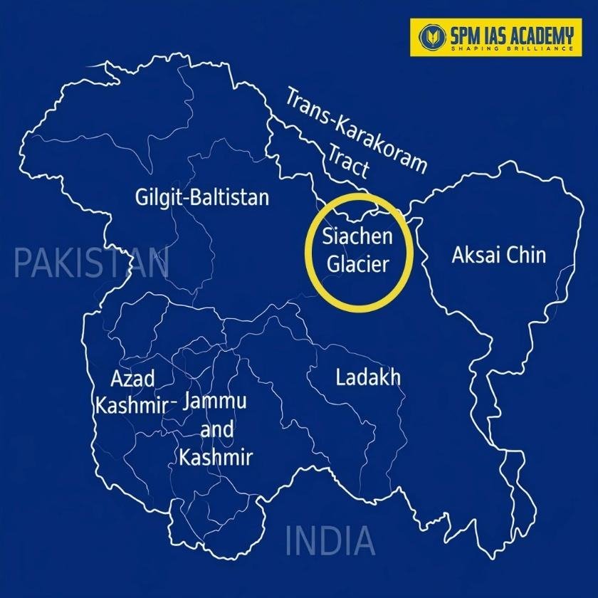
Where is Siachen Glacier Located? Geography and Key Facts
Understanding the location of the Siachen Glacier is important for any geography or current affairs question in competitive exams. Here are the key geographical facts:
- Location: Eastern Karakoram range, Ladakh, India.
- Length: Approximately 76 kilometres.
- Altitude: Starts above 5,400 metres; peaks go above 6,000 metres.
- Neighbouring regions: China’s Xinjiang to the north, Pakistan-administered Gilgit-Baltistan to the west.
- River: The Siachen River flows from the glacier into the Nubra River, and then into the Shyok River.
Geography of Siachen Glacier
- First, the Siachen Glacier is a piedmont glacier located in the Karakoram Range of the Himalayas.
- Moreover, it lies in the highly glaciated region known as the “Third Pole,” which stores the largest amount of freshwater outside the polar ice caps.
- In terms of location, the glacier lies between the Saltoro Ridge (to the west) and the main Karakoram Range (to the east).
- Additionally, the Siachen Glacier stretches approximately 75 km (47 miles), making it the second longest non-polar glacier in the world, after the Fedchenko Glacier in Tajikistan.
- Historically, scientists believe the glacier once extended up to 165 km (103 miles), based on geological evidence from glaciation events around 145,000 years ago.
Historical Background of the Siachen Conflict
The Shimla Agreement and the NJ 9842 Ambiguity
The Siachen dispute traces its roots back to the Shimla Agreement of 1972. After the 1971 Indo-Pak war, both nations signed this agreement to define the Line of Control (LoC) in Jammu and Kashmir. However, the agreement only drew the LoC up to a point called NJ 9842. Beyond this point, the text simply said the line would run ‘north to the glaciers.’ This vague language left the Siachen region undefined.
As a result, both India and Pakistan interpreted this boundary in their own way. Pakistan began issuing permits to foreign mountaineers to climb peaks in the Siachen region, treating it as their own territory. India noticed this development and decided to act fast.
Operation Meghdoot 1984: India Secures the Glacier
On 13 April 1984, India launched Operation Meghdoot. This was a swift military operation to occupy the Siachen Glacier before Pakistan could do the same. The Indian Army and Air Force worked together to airlift soldiers to the glacier. India successfully secured the Saltoro Ridge and the key passes – Sia La, Bilafond La, and Gyong La.
Consequently, India gained a dominant position on the Saltoro Ridge, which overlooks the Siachen Glacier. Since then, India has maintained continuous military presence on the glacier. Pakistan controls the area west of the Saltoro Ridge but has not been able to dislodge India from its vantage positions.
Strategic Importance of Siachen Glacier for India
Siachen is not just a glacier. It is a critical piece in India’s security architecture. Here is why Siachen has so much strategic importance for India:
- Buffer Zone: Siachen acts as a natural buffer between Pakistan and China. It prevents both countries from joining hands physically in this region.
- Control of Passes: India controls Sia La and Bilafond La. These high-altitude passes are strategically vital entry points.
- Intelligence Advantage: Troops stationed on the Saltoro Ridge can observe Pakistani and Chinese military movements in the surrounding areas.
- Water Security: The Siachen Glacier is a major source of freshwater. Rivers originating from this glacier feed millions of people in South Asia.
In addition, the Karakoram Highway passes through Pakistan-occupied Gilgit-Baltistan very close to this region. India’s presence at Siachen allows it to keep a close watch on this strategic road that connects Pakistan and China.
Challenges Faced by Indian Soldiers at Siachen
Siachen is one of the most difficult postings for any soldier in the world. The challenges are extreme and relentless.
- First, the temperature can fall to minus 60 degrees Celsius in winter.
- Second, the altitude causes serious health issues such as High Altitude Pulmonary Oedema (HAPO) and frostbite.
- Third, avalanches are a constant threat at this height.
Despite these hardships, the Indian Army continues to maintain its presence at Siachen. Soldiers serve on rotation in this region. The Army has developed specialised training, equipment, and logistics to support life and combat at such extreme altitudes. The sacrifice of these soldiers makes Siachen a symbol of courage and commitment for the entire nation.
Environmental Concerns at Siachen Glacier
Scientists and environmentalists have raised serious concerns about the Siachen Glacier. The glacier is melting at an alarming rate due to climate change and global warming. Military activities in the region also contribute to environmental stress. Studies show that the glacier has been retreating significantly over the past few decades.
Therefore, both India and Pakistan face pressure to demilitarise Siachen to protect this fragile ecosystem. However, India holds firm that demilitarisation must follow a formal agreement on the Actual Ground Position Line (AGPL). Without this, India risks losing the strategic advantage it gained in 1984.
India-Pakistan Talks on Siachen: Current Status
Both India and Pakistan have held several rounds of talks on the Siachen issue over the years. However, these talks have not produced any agreement so far. India insists on authenticating the Actual Ground Position Line (AGPL) before any troop withdrawal. Pakistan, on the other hand, wants both sides to withdraw to pre-1984 positions without authenticating current positions.
India’s concern is clear. Without map authentication, a future dispute could erase India’s hard-won military gains. Until Pakistan agrees to authenticate the AGPL, meaningful progress on Siachen demilitarisation remains unlikely.
Stay updated with current affairs to understand evolving geopolitical issues like the Siachen conflict.
Conclusion:
In conclusion, the Siachen Glacier stands as a critical symbol of India’s national security, military strategy, and geographical significance. Moreover, its location in the Karakoram range gives India a strong strategic advantage between Pakistan and China. However, the extreme climate and environmental concerns highlight the urgent need for sustainable management. Therefore, while India continues to maintain its presence after Operation Meghdoot, it must also balance security with ecological preservation. Ultimately, understanding the strategic importance of Siachen Glacier remains essential for both competitive exams and real-world geopolitics.
Source:
Frequently Asked Questions:
The Siachen Glacier is the world’s highest battlefield, located in the Karakoram range in Ladakh. Moreover, it holds immense strategic importance for India due to its location between Pakistan and China.
The location of Siachen Glacier is in the eastern Karakoram range in Ladakh. Additionally, it lies near Pakistan-occupied Gilgit-Baltistan and China’s Xinjiang region, making it geopolitically sensitive.
Operation Meghdoot (1984) was a military operation through which India secured control of the Siachen Glacier. As a result, Indian forces gained dominance over the Saltoro Ridge and key mountain passes.
Siachen is called the highest battlefield in the world because soldiers operate at altitudes above 5,400 metres. Furthermore, they face extreme weather conditions, including temperatures as low as minus 60°C.
The challenges in Siachen Glacier include extreme cold, low oxygen levels, avalanches, and health issues like frostbite and HAPO. Therefore, it is considered one of the toughest military postings globally.