The Teesta River is one of the most important rivers in northeastern India. It originates in the Himalayas and flows through Sikkim and West Bengal before joining the Brahmaputra in Bangladesh. UPSC, APSC, APPSC, and other state PCS aspirants must understand the Teesta River in detail, as questions related to its origin, length, location, tributaries, and political significance appear regularly in prelims and mains examinations. This article covers all the essential facts about the Teesta River.
For expert guidance, explore IAS coaching north east to strengthen your geography and current affairs preparation.
About Teesta River:
The Teesta River holds great geographical, ecological, and political importance. It is the lifeline of Sikkim and plays a vital role in the water resources of West Bengal and Bangladesh. Moreover, the river has been at the centre of a long-standing water-sharing dispute between India and Bangladesh, which makes it a hot topic in the international relations section of competitive exams.
Furthermore, the Teesta basin supports a rich biodiversity and sustains millions of people through agriculture and hydropower generation. Therefore, aspirants preparing for UPSC, APSC, APPSC, and state PCS exams must study this river thoroughly.
Teesta River Origin: Where Does It Begin?
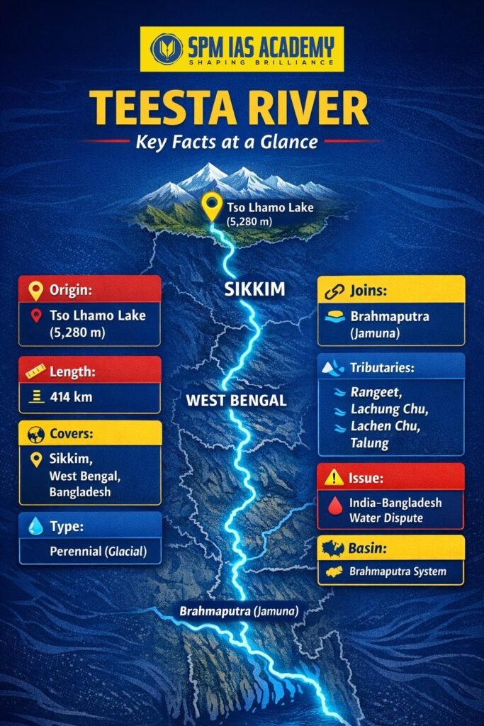
The Teesta River originates from the Tso Lhamo Lake, also known as Chho Lhamo Lake, in northern Sikkim at an altitude of approximately 5,280 metres above sea level. This glacial lake sits close to the China-India border. The river initially flows south through the mountainous terrain of Sikkim, carving deep valleys and gorges along the way.
Additionally, the Teesta receives water from several glaciers in the Sikkim Himalayas during its early course. As a result, it remains a perennial river, meaning it flows throughout the year. This glacial origin makes the Teesta a snow-fed river, which is an important fact for geography-related questions in competitive exams.
Teesta River Length and Location
How Long Is the Teesta River?
The total length of the Teesta River is approximately 414 kilometres. Out of this, around 151 kilometres of the river flows through Sikkim, while about 142 kilometres passes through the plains of West Bengal. The remaining stretch flows through Bangladesh, where it eventually meets the Brahmaputra River (locally called the Jamuna).
Location of Teesta River: Which States Does It Pass Through?
The Teesta River flows through three distinct zones.
- First, it passes through the high-altitude region of Sikkim, where it cuts through steep gorges.
- Second, it enters the Dooars region and flows through the northern plains of West Bengal.
- Third, it crosses the international border and flows through the Rangpur Division of Bangladesh before joining the Brahmaputra. Therefore, the river connects three regions with very different geographical and climatic features.
- The river enters the plains near Sevoke in West Bengal. The Sevoke-Teesta bridge and the nearby Coronation Bridge are well-known landmarks on this river.
- It then flows through districts like Jalpaiguri and Cooch Behar before crossing into Bangladesh.
Tributaries of the Teesta River:
The Teesta River receives water from several important tributaries. These tributaries add to its volume and flow. Here are the key tributaries of the Teesta River:
- Rangeet River: This is the most significant tributary. It joins the Teesta near Rangpo in Sikkim. The Rangeet itself has sub-tributaries like the Relli and the Riyang.
- Lachung Chu: This river originates in North Sikkim and merges with the Teesta at Chungthang, which is a major confluence point.
- Lachen Chu: Also known as the Zemu Chu, this river flows from the Zemu Glacier region and meets the Teesta at Chungthang along with the Lachung Chu.
- Talung River: This tributary flows from the slopes of Mount Pandim and joins the Teesta downstream.
- Kalijhora, Bhutia Busty, and Chel Rivers: These smaller rivers join the Teesta in the lower reaches near West Bengal.
Altogether, these tributaries make the Teesta a well-fed river that sustains both the hill and plains ecosystem.
Teesta River Water Dispute: Why Is It Important for Exams?
The Teesta River water dispute is one of the most discussed topics in the India-Bangladesh bilateral relations context. Bangladesh depends heavily on Teesta water for irrigation during the dry season. However, India and Bangladesh have not yet finalised a water-sharing treaty for this river.
India and Bangladesh almost signed a Teesta water-sharing agreement in 2011, but the deal did not go through because West Bengal raised objections. Since then, this issue has remained unresolved. Consequently, it continues to affect diplomatic relations between the two countries.
Stay updated with currentaffairs to understand topics like the Teesta River dispute for exams.
Ecological and Economic Importance of the Teesta River
The Teesta River basin supports a rich variety of flora and fauna. Furthermore, the river is home to several endangered species such as the Gangetic river dolphin and the golden mahseer fish. The Teesta river valley also falls within a biodiversity hotspot zone.
In terms of economy, the Teesta River supports the following activities:
- Hydropower generation: Sikkim generates a large portion of its electricity from Teesta-based hydroelectric projects such as the Teesta Stage III, IV, V, and VI projects.
- Irrigation: Farmers in West Bengal and Bangladesh rely on Teesta water for growing rice and vegetables.
- Tourism and adventure sports: The Teesta River is famous for white-water river rafting, especially in the Sikkim stretch. This attracts tourists from across the country.
However, the river also faces threats from excessive damming, flash floods, and glacial lake outburst floods (GLOFs). The 2023 Teesta GLOF disaster in Sikkim caused massive destruction.
Key Facts About the Teesta River at a Glance
Here is a summary of the most important facts about the Teesta River that every exam aspirant must remember:
Conclusion:
In conclusion, the Teesta River plays a crucial role in the geography, economy, and international relations of South Asia. It originates from the glacial region of Sikkim and flows through diverse terrains before joining the Brahmaputra River, thereby forming an essential part of the Brahmaputra drainage system. Moreover, its perennial nature and major tributaries ensure a steady water supply for agriculture, hydropower, and biodiversity conservation.
Furthermore, the Teesta River water dispute between India and Bangladesh highlights its geopolitical importance, making it a significant topic for competitive exams like UPSC, APSC, and APPSC. Therefore, aspirants must clearly understand key aspects such as the Teesta River origin, length, tributaries, and location to strengthen their conceptual clarity.
Overall, the Teesta River remains not only a lifeline for millions but also a highly relevant topic for exam preparation. Hence, mastering the key facts about the Teesta River will definitely help candidates score better in geography and current affairs sections.
Source:
Frequently Asked Questions:
The Teesta River originates from the Tso Lhamo Lake (also called Chho Lhamo Lake) in the North Sikkim district of Sikkim, India. This glacial lake sits at an altitude of approximately 5,280 metres above sea level near the India-China border.
The total length of the Teesta River is approximately 414 kilometres. It flows through Sikkim (~151 km) and West Bengal (~142 km) in India before entering Bangladesh, where it joins the Brahmaputra River.
The Teesta River ultimately joins the Brahmaputra River in Bangladesh. In Bangladesh, people locally call the Brahmaputra the Jamuna River. The Teesta meets this river in the Rangpur Division of Bangladesh.
The main tributaries of the Teesta River include the Rangeet River, Lachung Chu, Lachen Chu (Zemu Chu), and the Talung River. Among these, the Rangeet River is the most important tributary. It joins the Teesta near Rangpo in Sikkim.
The Teesta River is important for UPSC and APSC exams because it covers multiple key topics such as Teesta River origin, length, tributaries, location, and water dispute. Moreover, the river plays a crucial role in geography, environment, and international relations due to the ongoing India–Bangladesh Teesta water-sharing issue. Therefore, aspirants must study the Teesta River in detail to improve their chances of scoring well in both prelims and mains examinations.