The Jhelum River is one of the most important rivers of the Indian subcontinent and a major tributary of the Indus River system. It originates from the Verinag Spring in the Pir Panjal range of the Himalayas in Jammu and Kashmir. The river flows through the Kashmir Valley, enters Pakistan, and finally joins the Chenab River. The Jhelum River is famous for its historical, geographical, and strategic significance.
For UPSC, APSC, and other State PCS aspirants, the Jhelum River is a frequently asked topic. It comes under the topics of Geography, Environment, and Current Affairs sections. This article covers all essential aspects of the Jhelum River including its origin, map details, dams, ancient name, and its overall course.
Explore expert guidance through upsc coaching in north east india for structured and result-oriented UPSC preparation.
Jhelum River: Quick Facts at a Glance
- Ancient Name: Vitasta (in Sanskrit), Hydaspes (in Greek)
- Origin: Verinag Spring, Pir Panjal Range, Jammu and Kashmir, India
- Total Length: Approximately 725 kilometres
- Drains Into: Joins the Chenab River in Pakistan
- River System: Tributary of the Indus River
- Countries: India and Pakistan
- Major Lake: Dal Lake and Wular Lake (connected to the Jhelum)
- Indus Waters Treaty: The Jhelum is a Western River assigned to Pakistan under the 1960 Indus Waters Treaty
Where Is the Jhelum River? Location and Course
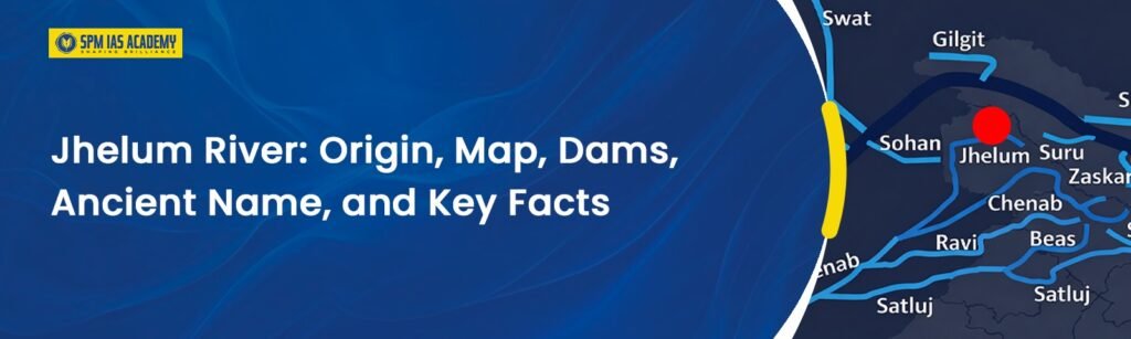
The Jhelum River flows through two countries – India and Pakistan. It starts its journey in the Himalayan region of India and ends by merging with the Chenab River in Pakistan. Understanding its geographical location is very important for UPSC and State PCS Geography questions.
In India
The Jhelum River begins in Jammu and Kashmir, India. It originates from the Verinag Spring at the base of the Pir Panjal range in the southeastern part of the Kashmir Valley. After rising from this spring, the river flows northwest through the beautiful Kashmir Valley. It passes through Anantnag and then flows through Srinagar, the summer capital of Jammu and Kashmir. Along the way, it feeds the famous Dal Lake and Wular Lake, which are two of the largest freshwater lakes in India.
Furthermore, the river passes through the Wular Lake and then cuts through the Pir Panjal range via a gorge near Baramulla. After leaving the Kashmir Valley, it enters Pakistan-administered Kashmir (PoK) near Uri.
In Pakistan
After entering Pakistan, the Jhelum River flows through Azad Kashmir (PoK). Then it enters into the Punjab province of Pakistan. It passes through the cities of Muzaffarabad and Jhelum (the city after which the river gets its present name). Subsequently, the river merges with the Chenab River near Trimmu Headworks in Punjab, Pakistan. This confluence is an important geographical fact for competitive exams.
Jhelum River Origin: Where Does It Begin?
The Jhelum River originates from the Verinag Spring, located in the Anantnag district of Jammu and Kashmir, India. This spring sits at the base of the Pir Panjal range, which is part of the Lesser Himalayas.
The Verinag Spring is a beautiful octagonal pool built by the Mughal Emperor Jahangir in 1620 A.D. It is considered one of the most scenic spots in Kashmir. The water that gushes out of this spring is cold, crystal clear, and copious. From this spring, the river initially flows as a small stream called Veth in Kashmiri language.
As it moves northwest, the river gains strength from several tributaries. The main tributaries that join it in the Kashmir Valley include the Kishanganga (now called Neelum River after it enters Pakistan), the Pohru, the Sindh, the Lidder, and the Rambiara rivers. Together, these tributaries make the Jhelum a large and powerful river by the time it leaves the Kashmir Valley.
What Was the Ancient Name of the River Jhelum?
The ancient name of the Jhelum River was Vitasta. This name appears in the Rigveda, one of the oldest scriptures of ancient India. The Rigveda mentions Vitasta as one of the sacred rivers of the land. Therefore, the Jhelum River has one of the oldest recorded names among all rivers of the Indian subcontinent.
In ancient Greek texts, the river is called Hydaspes. Greek historians and writers used this name during the time of Alexander the Great. The Battle of the Hydaspes, fought in 326 BCE on the banks of this river.
The current name Jhelum comes from the city of Jhelum in present-day Pakistan, through which the river passes. Over the centuries, the name Vitasta gradually gave way to the present name Jhelum.
The Battle of the Hydaspes (326 BCE) – Historical Significance
The Battle of the Hydaspes was fought between Alexander the Great and King Porus (Paurava) of the Paurava Kingdom in 326 BCE. This battle took place on the banks of the Jhelum River. Alexander won the battle but was so impressed by Porus’s bravery that he returned the kingdom to him.
This battle is significant because it marked the easternmost military campaign of Alexander the Great. After this battle, his army refused to march further into India. Consequently, Alexander turned back, and his Indian campaign ended at the banks of the Jhelum River.
Jhelum River Map: Understanding the River’s Geography
For map-based questions in UPSC and State PCS exams, aspirants must understand the complete geographical course of the Jhelum River.
Origin Point:
The Jhelum River begins at the Verinag Spring located in the southeastern part of the Kashmir Valley, near Anantnag in Jammu and Kashmir. The approximate coordinates of the origin are 33.5 degrees North latitude and 75.3 degrees East longitude.
Course of Jhelum river:
The Jhelum River flows in a broadly northwest direction from its origin. It sweeps across the Kashmir Valley, enters PoK, and then flows southwest through the plains of Pakistani Punjab before finally meeting the Chenab River.
Key Cities on the Bank of Jhelum River
- Anantnag (India): Near the origin of the river
- Srinagar (India): The most important city through which the Jhelum flows in India
- Baramulla (India): The last major town in India before the river enters PoK
- Muzaffarabad (PoK): Major city in Azad Kashmir on the Jhelum River
- Jhelum City (Pakistan): The city in Pakistan’s Punjab after which the river is named
- Trimmu (Pakistan): The confluence point where the Jhelum meets the Chenab River
Tributaries of the Jhelum River
Right Bank Tributaries (join from the right side):
- Kishanganga River (Neelum River in Pakistan)
- Pohru River
Left Bank Tributaries (join from the left side):
- Sindh River
- Lidder River
- Rambiara River
- Kunhar River
Dam on Jhelum River: List of Major Dams and Projects
Several important dams and hydroelectric projects exist on the Jhelum River and its tributaries. These dams serve purposes of irrigation, power generation, and flood control.
1. Uri Hydroelectric Dam (India)
- Location: Uri, Baramulla district, Jammu and Kashmir
- Capacity: Uri-I has 480 MW and Uri-II has 240 MW of installed power capacity
- Purpose: Hydroelectric power generation
- Significance: One of the most important power projects in Jammu and Kashmir
2. Salal Dam (India – on Chenab, relevant context)
Although the Salal Dam is on the Chenab River, it is important to note in the context of the Jhelum because both rivers are part of the same Indus River system and are governed by the Indus Waters Treaty.
3. Kishanganga Hydroelectric Project (India)
- Location: Bandipore district, Jammu and Kashmir
- River: Kishanganga River, a tributary of the Jhelum
- Capacity: 330 MW
- Significance: This project was disputed between India and Pakistan. Pakistan raised objections at the Permanent Court of Arbitration over the diversion of the Kishanganga River.
4. Mangla Dam (Pakistan)
- Location: Mirpur, Azad Kashmir, Pakistan
- River: Jhelum River
- Type: Earthfill dam
- Purpose: Irrigation, hydroelectric power (1,000 MW capacity), and flood control
- Significance: One of the largest dams in the world when it was completed in 1967. It is a crucial water storage and power project for Pakistan.
5. Rasul Barrage (Pakistan)
- Location: Mandi Bahauddin district, Punjab, Pakistan
- River: Jhelum River
- Purpose: Irrigation and power generation
Jhelum River and the Indus Waters Treaty (IWT) 1960
The Indus Waters Treaty is one of the most important water-sharing agreements in the world. India and Pakistan signed this treaty on 19 September 1960, with the World Bank acting as a mediator. The treaty divided the six rivers of the Indus River system between the two countries.
Under this treaty, the three Western Rivers – the Indus, the Jhelum, and the Chenab were assigned to Pakistan. This means Pakistan has the exclusive right to use the waters of these three rivers. However, India retains limited rights to use the water of the Jhelum River. This limited rights extends to domestic use, non-consumptive purposes, agriculture, and run-of-the-river hydroelectric projects without creating large storage.
Stay updated with the latest current affairs to strengthen your geography and environment preparation for competitive exams.
Jhelum River and Wular Lake: An Important Connection
The Jhelum River flows into and out of Wular Lake. The Wular lake is located between the towns of Sopur and Bandippore, in Sangrama, near Baramula, Jammu and Kashmir. Wular Lake is the largest freshwater lake in India and 2nd largest fresh water lake of Asia.
The Jhelum River acts as both a feeder and a drain for Wular Lake. During floods, the lake absorbs the excess water from the river and thus helps in flood control. This natural flood regulation function of Wular Lake is very important for the Kashmir Valley.
The Tulbul Navigation Project (also called the Wular Barrage project) is a barrage that India proposed to build on the Jhelum River at the outlet of Wular Lake. However, Pakistan objected to this project under the Indus Waters Treaty, and the project has remained stalled since the 1980s.
Ecological and Environmental Significance of the Jhelum River
The Jhelum River supports a rich biodiversity in the Kashmir Valley. It provides habitat for a variety of fish species, including the famous Kashmiri trout (Snow Trout). The river system also supports wetland ecosystems around Wular Lake and Hokersar Lake, which are important habitats for migratory birds.
However, the Jhelum River today faces serious environmental threats. Rapid urbanisation in Srinagar has led to heavy pollution of the river through untreated sewage and solid waste disposal. Additionally, encroachment on the river floodplains and wetlands has severely reduced its natural flood absorption capacity. The devastating floods of September 2014 in Kashmir were partly a result of this reduction in the river’s natural buffering capacity.
Furthermore, climate change poses a growing threat to the Jhelum River. The retreating glaciers in the Himalayas will ultimately reduce the long-term water flow in the river. This has serious implications for both agriculture and drinking water supply in the Kashmir Valley and in Pakistan’s Punjab province.
Historical and Cultural Significance of the Jhelum River
The Jhelum River holds immense historical and cultural importance for the people of Kashmir and the wider Indian subcontinent.
- Vedic Heritage: The river is mentioned as Vitasta in the Rigveda, making it one of the oldest named rivers in human history.
- Alexander’s Campaign: The Battle of the Hydaspes (326 BCE) on its banks marked the eastern limit of Alexander’s conquests.
- Mughal Connection: Mughal Emperor Jahangir beautified the Verinag Spring (the river’s source) and wrote lovingly about Kashmir and the Jhelum River in his memoirs (Tuzuk-i-Jahangiri).
- Kashmiri Identity: The Jhelum River is the lifeline of the Kashmir Valley. The iconic Dal Lake houseboats and the shikaras (traditional wooden boats) of Srinagar are closely associated with the cultural life along the Jhelum.
- Literary Significance: Kalhana’s Rajatarangini, the famous 12th-century chronicle of Kashmir, frequently mentions the Vitasta (Jhelum) as the central river of the Kashmir Valley.
Conclusion:
In conclusion, the Jhelum River holds immense geographical, historical, and strategic importance in the Indian subcontinent. Moreover, its connection with major water bodies like Dal Lake and Wular Lake further enhances its ecological significance. Furthermore, the Jhelum River plays a crucial role in international relations due to the Indus Waters Treaty (1960).
Overall, the Jhelum River is not only a lifeline for the Kashmir Valley but also a highly relevant topic in geography, environment, and current affairs. Hence, mastering the key facts about the Jhelum River will significantly strengthen exam preparation.
Source:
Frequently Asked Questions:
The Jhelum River origin lies at the Verinag Spring in the Pir Panjal Range of Jammu and Kashmir, India. Moreover, this spring marks the beginning of the river’s journey through the Kashmir Valley before it enters Pakistan.
The Jhelum River flows from India to Pakistan, passing through the Kashmir Valley and Punjab region. Subsequently, it joins the Chenab River in Pakistan. Hence, the Jhelum River forms an important tributary of the Indus River system.
The ancient name of the Jhelum River is Vitasta in Sanskrit and Hydaspes in Greek. Furthermore, ancient texts like the Rigveda mention Vitasta as a sacred river. Therefore, this historical aspect makes the Jhelum River important for both history and geography sections.
The significance of Jhelum River in the Indus Waters Treaty lies in its classification as a Western River. Consequently, Pakistan receives primary rights over its waters, while India uses it for limited purposes like hydropower and irrigation.
The Jhelum River connects with major lakes such as Dal Lake and Wular Lake. Moreover, Wular Lake acts as a natural flood reservoir, helping regulate water flow. Therefore, these lakes enhance the ecological and geographical importance of the Jhelum River.