
When you look at a map of India’s northeastern corner, Arunachal Pradesh geography stands out immediately, it is the largest state in the Northeast, packed with mountains, dense forests, major rivers, a rich tribal heritage, and some of the most strategically important international borders in the country. For UPSC, APSC, and other competitive exam aspirants, this state is a goldmine of GK questions. This blog covers every key aspect of Arunachal Pradesh geography, from its districts and borders to its tribes, rivers, climate, and physical features, so that you have everything in one place.
Students preparing Northeast geography topics can strengthen concepts through comprehensive UPSC coaching in Assam.
Where Is Arunachal Pradesh Located, and What Makes It So Unique?

Arunachal Pradesh geography begins with its position. The state sits at the northeastern tip of India and shares international borders with three countries, China to the north and northeast, Bhutan to the west, and Myanmar to the east. Within India, it shares borders with Assam to the south and Nagaland to the southeast. This combination of international and domestic boundaries makes Arunachal Pradesh geography one of the most strategically significant in the country.
The state covers a total area of approximately 83,743 square kilometres, making it the largest state in the entire Northeast region. Its capital is Itanagar, located in the Papum Pare district. The state became a Union Territory in 1972 and achieved full statehood on 20th February 1987. The name Arunachal Pradesh translates literally to “Land of the Dawn-Lit Mountains,” a name that reflects both its position as the first part of India to receive sunlight and the mountainous terrain that defines its landscape.
What Does the Physical Landscape of Arunachal Pradesh Look Like?
One of the most defining features of Arunachal Pradesh geography is its dramatic elevation range. The state rises from the plains of Assam in the south to some of the highest peaks of the Eastern Himalayas in the north. The terrain moves through foothills, river valleys, forested hills, and snow-capped mountain ranges as you travel northward.
The highest peak in the state is Kangto, followed by Nyegi Kangsang. The Eastern Himalayas dominate the northern landscape, with several ranges including the Mishmi Hills in the east, the Naga Hills in the southeast, and the Patkai Range along the Myanmar border. The Siang River valley in the central part of the state and the Tawang plateau in the west are two of the most geographically distinct zones within the state.
The state lies largely between 26°28′ N to 29°30′ N latitude and 91°30′ E to 97°30′ E longitude.
Aspirants covering tribal culture and border studies often prefer structured UPSC coaching in north east India.
What Are the Districts of Arunachal Pradesh?
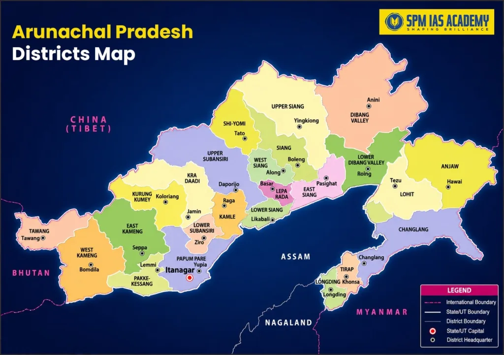
Arunachal Pradesh geography is administered through 26 districts. Understanding the district structure helps in answering questions related to administrative divisions, tribal distribution, and economic profiles. The districts are:
| District | Headquarters |
| Anjaw | Hawai |
| Chang Lang | Changlang |
| Dibang Valley | Anini |
| East Kameng | Seppa |
| East Siang | Pasighat |
| Itanagar (Capital District) | Itanagar |
| Kamle | Raga |
| Kra Daadi | Ziro (partially) |
| Kurung Kumey | Koloriang |
| Lepa Rada | Along (partially) |
| Lohit | Tezu |
| Longding | Longding |
| Lower Dibang Valley | Roing |
| Lower Siang | Likabali |
| Lower Subansiri | Ziro |
| Namsai | Namsai |
| Pakke Kessang | Pakke Kessang |
| Papum Pare | Yupia |
| Shi Yomi | Tato |
| Siang | Boleng |
| Tawang | Tawang |
| Tirap | Khonsa |
| Upper Dibang Valley | Anini |
| Upper Siang | Yingkiong |
| Upper Subansiri | Daporijo |
| West Kameng | Bomdila |
| West Siang | Alon |
Pasighat in East Siang is the oldest town in the state. Tawang is the most strategically sensitive and culturally significant district, home to the Tawang Monastery, the largest Buddhist monastery in India and one of the largest in the world.
Along with General Studies, mastering the UPSC language paper is essential for Mains qualification.
What International Borders Does Arunachal Pradesh Share?
The international boundaries of Arunachal Pradesh are among the most discussed and contested in India’s diplomatic landscape.
Border with China: The northern and northeastern boundary of Arunachal Pradesh runs along what India recognizes as the McMahon Line, a boundary demarcated during the Simla Convention of 1914. China does not accept this boundary and claims most of Arunachal Pradesh as part of its territory, referring to it as “South Tibet.” This border stretches for approximately 1,080 kilometers and remains one of the most geopolitically sensitive international borders in Asia.
Border with Bhutan: The western boundary of Arunachal Pradesh runs along Bhutan for approximately 160 kilometers. This is a relatively quieter boundary compared to the China border, though some sections remain under diplomatic discussion.
Border with Myanmar: The eastern boundary runs along Myanmar for approximately 440 kilometers, passing through the districts of Changlang, Tirap, and Longding. This border passes through the Patkai Range and remains forested and relatively remote.
Together, these international borders give Arunachal Pradesh geography a total international boundary length of roughly 1,680 kilometers, making it one of the states with the longest international borders in India.
Which Tribes Live in Arunachal Pradesh, and How Many Are There?
Arunachal Pradesh is one of the most tribally diverse states in all of India, and this forms a major part of Arunachal Pradesh geography in its cultural dimension. The state is home to over 26 major tribes and more than 100 sub-tribes, each with their own distinct language, dress, customs, and traditions.
Some of the most important tribes for examination purposes are listed below.
| Tribe | Region / District |
| Adi | East Siang, Upper Siang |
| Apatani | Lower Subansiri (Ziro Valley) |
| Nyishi | Papum Pare, East Kameng |
| Galo | West Siang |
| Monpa | Tawang, West Kameng |
| Mishmi | Dibang Valley, Lohit |
| Nocte | Tirap |
| Wancho | Longding |
| Tangsa | Changlang |
| Chakma | Changlang |
| Singpho | Changlang, Namsai |
| Hill Miri | Kurung Kumey |
| Tagin | Upper Subansiri |
The Apatani tribe of the Ziro Valley is particularly well known for their unique agricultural practices and their UNESCO-listed Ziro Festival of Music. The Monpa tribe of Tawang follows Tibetan Buddhism and is closely connected to the cultural traditions of the Tawang Monastery. The Adi tribe is the largest tribal group in the state.
The scheduled tribe population accounts for a very large proportion of the total population of Arunachal Pradesh, which stands at approximately 14 lakh people as per the 2011 Census. The population density of the state is among the lowest in India at around 17 persons per square kilometer, which reflects the vast forested and mountainous terrain that Arunachal Pradesh geography encompasses.
What Are the Major Rivers That Flow Through Arunachal Pradesh?
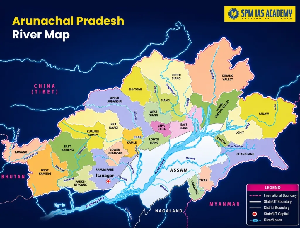
Rivers form one of the most important components of Arunachal Pradesh geography, both in terms of the state’s ecology and its hydropower potential. The state is drained by a number of major river systems, most of which eventually flow into the Brahmaputra in Assam.
Siang (Brahmaputra): The Siang River is the main river system of the state and is the Indian stretch of the Yarlung Tsangpo, which originates in Tibet. After entering Arunachal Pradesh from China through the Siang district, it flows southward through deep gorges before entering Assam where it becomes the Brahmaputra. The Siang is the principal waterway of Arunachal Pradesh geography and forms the backbone of the state’s river network.
Subansiri: The Subansiri River flows through the Subansiri districts and is one of the largest tributaries of the Brahmaputra. It is also one of the most significant rivers for hydropower development in the state.
Kameng: The Kameng River flows through the West Kameng and East Kameng districts and joins the Brahmaputra in Assam. The Pakke Wildlife Sanctuary sits along the Pakke River, a tributary of the Kameng.
Lohit: The Lohit River enters Arunachal Pradesh from China through the Anjaw district and flows through the Lohit district before joining the Brahmaputra. The Mishmi Hills surround this river valley.
Dibang: The Dibang River flows through the Dibang Valley districts and is one of the main tributaries of the Brahmaputra. The Dibang Valley is one of the most remote and least populated regions in India.
Tirap and Noa-Dihing: These rivers flow through the Tirap and Changlang districts in the southeastern part of the state.
| River | Major Districts | Joins |
| Siang | Siang, East Siang, Upper Siang | Brahmaputra (Assam) |
| Subansiri | Lower Subansiri, Upper Subansiri | Brahmaputra (Assam) |
| Kameng | West Kameng, East Kameng | Brahmaputra (Assam) |
| Lohit | Anjaw, Lohit | Brahmaputra (Assam) |
| Dibang | Dibang Valley, Lower Dibang Valley | Brahmaputra (Assam) |
| Tirap | Tirap | Brahmaputra system |
All these rivers carry enormous hydropower potential, and Arunachal Pradesh is often called the “Power House of India” because of its estimated hydropower capacity of over 50,000 MW, the highest of any state in the country.
What Is the Climate of Arunachal Pradesh Like?
The climate of Arunachal Pradesh geography varies enormously from south to north because of the dramatic change in elevation. The southern foothills receive very heavy rainfall, some areas like the Subansiri and Siang valleys receive over 4,000 mm of rainfall annually, making them among the wettest zones in India. The state receives most of its rainfall from the Southwest Monsoon between June and September.
As elevation increases moving northward, temperatures drop significantly. The northern districts of Tawang, Upper Siang, and Dibang Valley experience sub-zero temperatures during winter and remain under snow for several months. The Tawang district, at altitudes above 3,000 meters, has alpine conditions for much of the year.
The middle zone, which covers much of the state’s interior valleys, has a subtropical climate with warm summers and mild winters, making it the zone where most of the agricultural and human activity in the state is concentrated.
What National Parks and Wildlife Reserves Does the State Have?
Arunachal Pradesh geography includes some of India’s most biodiverse wildlife areas. The state is part of the Eastern Himalayan Biodiversity Hotspot, one of the 36 globally recognized biodiversity hotspots.
Key protected areas include Namdapha National Park, which is the third largest national park in India and one of the few places in the world where four species of big cats, tiger, leopard, snow leopard, and clouded leopard, coexist. Pakke Tiger Reserve in East Kameng is another important conservation area. Mouling National Park in Upper Siang, Kamlang Wildlife Sanctuary in Lohit, and Tale Valley Wildlife Sanctuary in Lower Subansiri are among the other significant protected areas that enrich Arunachal Pradesh geography in ecological terms.
Conclusion
Arunachal Pradesh geography is one of the richest and most multifaceted topics in Indian GK, it combines physical geography, political geography, tribal diversity, river systems, and ecological significance all in one frame. From its 26 districts and three international borders spanning over 1,680 kilometers to its 26-plus major tribes and river systems like the Siang, Lohit, Dibang, Subansiri, and Kameng, every aspect of Arunachal Pradesh geography carries exam-relevant facts that appear regularly in UPSC, APSC, and state-level competitive papers. Going through all sections of this blog carefully and revisiting the tables will give you a strong hold on this topic before your next examination.
Frequently Asked Questions
Arunachal Pradesh is widely known for its tribal cultural diversity; the Tawang Monastery, which is the largest Buddhist monastery in India; its position as the first region in India to receive sunlight; and its strategic location bordering China, Bhutan, and Myanmar. Its massive hydropower potential and biodiversity also make it a significant state in national discussions.
Arunachal Pradesh’s geography is home to over 26 major tribes and more than 100 sub-tribes, making it one of the most tribally diverse states in the country. Major tribes include the Adi, Apatani, Nyishi, Galo, Monpa, Mishmi, Noctes, Wancho, and Tangsa, each concentrated in specific districts with their own distinct language and cultural traditions.
The Siang River is the principal waterway in Arunachal Pradesh’s geography. It is the Indian segment of the Yarlung Tsangpo, originating in Tibet and flowing southward through deep Himalayan gorges before entering Assam where it becomes the mighty Brahmaputra. Other major rivers include the Subansiri, Kameng, Lohit, and Dibang, all of which eventually merge into the Brahmaputra.

Behind every article at SPM IAS Academy is a team of skilled content writers and subject experts committed to making preparation easier for aspirants. From answering common doubts to breaking down complex issues and current affairs, we create content that is accurate, easy to understand, and directly useful for UPSC, APSC, and other competitive exams.